Dangerous storm southeast of Arley is moving southeast at 15 mph. Another is just east of Double Springs. Both show large hail.
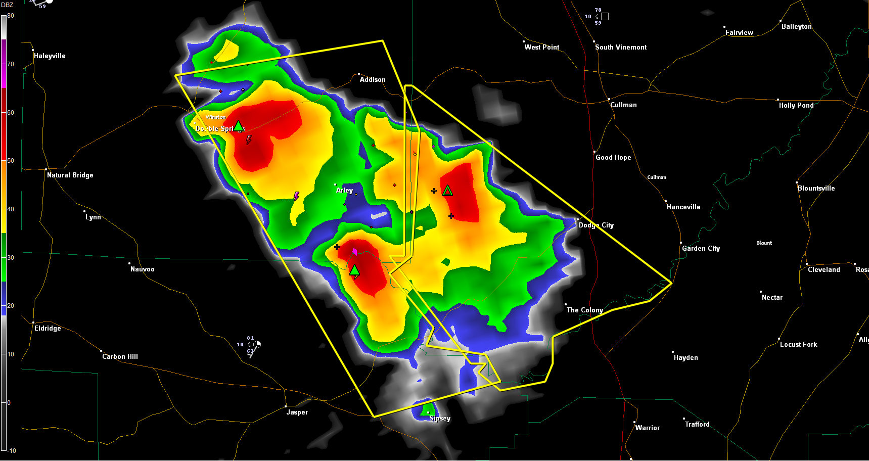
The storms could also produce damaging winds.
It will move over Smith Lake and pass near Powellville before moving into northeastern Walker County. It could eventually impact Sipsey.
the NWS in Huntsville has issued a severe thunderstorm warning for CUllman County as well. The same storm will impact areas over to Dodge City and The Colony.
ADVERTISEMENT
Getting severe weather alerts immediately wherever you are is a critical part of protecting yourself and your family. Bill Murray’s simple new iPhone app MyWARN delivers lifesaving tornado, severe thunderstorm and flash flood watches and warnings to you anywhere, based on your phone’s location based services. Take advantage of a special one time price offer for AlabamaWX.com readers.
WUUS54 KBMX 312208
SVRBMX
ALC127-133-312300-
/O.NEW.KBMX.SV.W.0072.120331T2208Z-120331T2300Z/
BULLETIN – IMMEDIATE BROADCAST REQUESTED
SEVERE THUNDERSTORM WARNING
NATIONAL WEATHER SERVICE BIRMINGHAM AL
508 PM CDT SAT MAR 31 2012
THE NATIONAL WEATHER SERVICE IN BIRMINGHAM HAS ISSUED A
* SEVERE THUNDERSTORM WARNING FOR…
NORTHEASTERN WALKER COUNTY IN ALABAMA…
EASTERN WINSTON COUNTY IN NORTHWEST ALABAMA…
* UNTIL 600 PM CDT
* AT 507 PM CDT…THE NATIONAL WEATHER SERVICE INDICATED A SEVERE
THUNDERSTORM CAPABLE OF PRODUCING GOLF BALL SIZE HAIL…AND
DAMAGING WINDS IN EXCESS OF 60 MPH. THIS STORM WAS LOCATED NEAR
LAKE SHORE…OR 7 MILES SOUTH OF ARLEY…AND MOVING SOUTHEAST AT 15
MPH.
* LOCATIONS IMPACTED INCLUDE…
POWELLVILLE.
PRECAUTIONARY/PREPAREDNESS ACTIONS…
FOR YOUR PROTECTION…MOVE TO AN INTERIOR ROOM ON THE LOWEST FLOOR OF
YOUR HOME OR BUSINESS.
&&
TO REPORT SEVERE WEATHER…
CALL 1-800-856-0758.
LAT…LON 3414 8710 3400 8711 3398 8714 3392 8708
3390 8709 3389 8701 3386 8699 3382 8716
3420 8743 3424 8715
TIME…MOT…LOC 2208Z 320DEG 14KT 3398 8717
$$
56
WWWW