


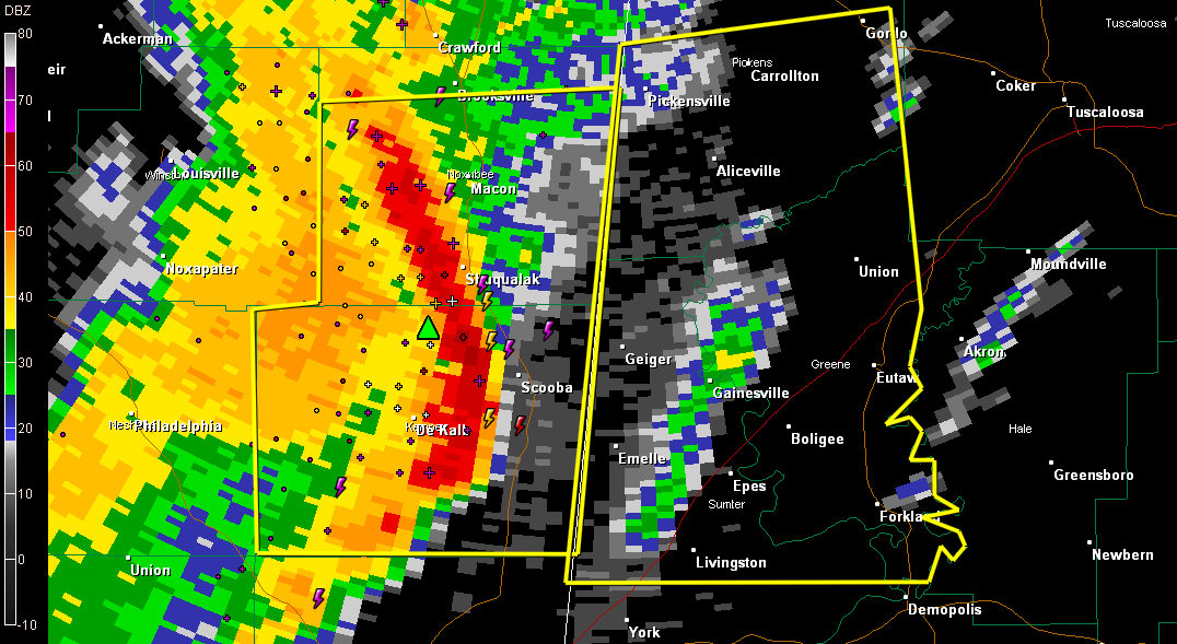
These are the communities in the new severe thunderstorm warning.
A bow echo is about to enter West Alabama’s Pickens and Sumter Counties. It will progress into Greene County. Doppler Radar shows high winds just off the surface and reflectivity on radar is increasing, indicating an increasing chance these high winds will reach the ground.
There haven’t been many recent reports of wind damage from eastern Mississippi, but as instabilities increase, that could change.
Please take thee storms seriously in the warning area. Leave mobile homes before they arrive and be in a sturdy house or building. Don’t be driving as the storms reach your location.
ADVERTISEMENT
Getting severe weather alerts immediately wherever you are is a critical part of protecting yourself and your family. Bill Murray’s simple new iPhone app MyWARN delivers lifesaving tornado, severe thunderstorm and flash flood watches and warnings to you anywhere, based on your phone’s location based services. Take advantage of a special one time price offer for AlabamaWX.com readers.
THE NATIONAL WEATHER SERVICE IN BIRMINGHAM HAS ISSUED A
* SEVERE THUNDERSTORM WARNING FOR…
GREENE COUNTY IN WEST CENTRAL ALABAMA…
SOUTHERN PICKENS COUNTY IN WEST CENTRAL ALABAMA…
NORTHERN SUMTER COUNTY IN WEST CENTRAL ALABAMA…
* UNTIL 1045 AM CDT
* AT 937 AM CDT…THE NATIONAL WEATHER SERVICE INDICATED A LINE OF
SEVERE THUNDERSTORMS CAPABLE OF PRODUCING QUARTER SIZE HAIL…AND
DESTRUCTIVE WINDS IN EXCESS OF 70 MPH. THESE STORMS WERE LOCATED
ALONG A LINE EXTENDING FROM 22 MILES WEST OF PICKENSVILLE TO 15
MILES NORTHWEST OF EMELLE TO 15 MILES WEST OF BOYD…AND MOVING
EAST AT 40 MPH.
* LOCATIONS IMPACTED INCLUDE…
PICKENSVILLE…LIVINGSTON…ALICEVILLE…CARROLLTON…EUTAW…
GORDO…EMELLE AND BOYD.
THIS INCLUDES…
INTERSTATE 20 EXIT NUMBERS 17 THROUGH 45…
PRECAUTIONARY/PREPAREDNESS ACTIONS…
INTENSE SQUALL LINES CAN OCCASIONALLY PRODUCE BRIEF TORNADOES IN
ADDITION TO WIDESPREAD SIGNIFICANT WIND DAMAGE. ALTHOUGH NOT
IMMEDIATELY LIKELY…FOR YOUR PROTECTION MOVE TO AN INTERIOR ROOM ON
THE LOWEST FLOOR OF YOUR HOME OR BUSINESS. THIS STORM HAS THE
POTENTIAL TO CAUSE SERIOUS INJURY AND SIGNIFICANT DAMAGE TO PROPERTY.



