


…THE SEVERE THUNDERSTORM WARNING FOR EASTERN BLOUNT COUNTY WILL
EXPIRE AT 400 AM CDT…
The storms which prompted the warning have moved out of the area.
Therefore, the warning will be allowed to expire.
A Severe Thunderstorm Watch remains in effect until 600 AM CDT for
central and northeastern Alabama.
To report severe weather, contact your nearest law enforcement
agency. They will relay your report to the National Weather Service
Birmingham.
A Severe Thunderstorm Warning Remains In Effect Until 4:00 AM CDT For Eastern Blount County
Jun 20th @ 3:45 am

…A SEVERE THUNDERSTORM WARNING REMAINS IN EFFECT UNTIL 400 AM CDT FOR EASTERN BLOUNT COUNTY… At 344 AM CDT, severe thunderstorms were located along a line extending from near Guntersville to near Ashville, moving east at 50 mph.
HAZARD…60 mph wind gusts and penny size hail.
SOURCE…Radar indicated.
IMPACT…Expect damage to roofs, siding, and trees. Locations impacted include… Oneonta, Altoona, Snead, Susan Moore, Walnut Grove, Allgood, Rosa, McLarty, Inland Lake, Brooksville, Highland Lake, Holly Springs, Hendrix and Easley.
A Severe Thunderstorm Warning Remains In Effect Until 4:00 AM CDT For Blount County
Jun 20th @ 3:27 am

…A SEVERE THUNDERSTORM WARNING REMAINS IN EFFECT UNTIL 400 AM CDT FOR BLOUNT COUNTY… At 327 AM CDT, severe thunderstorms were located along a line extending from near Arab to near Inland Lake, moving east at 50 mph.
HAZARD…60 mph wind gusts and penny size hail.
SOURCE…Radar indicated.
IMPACT…Expect damage to roofs, siding, and trees. Locations impacted include… Oneonta, Blountsville, Cleveland, Locust Fork, Altoona, Snead, Susan Moore, Walnut Grove, Allgood, Fairview, Nectar, Rosa, McLarty, Inland Lake, Strawberry, Brooksville, Highland Lake, Easley, Chamblees Mill and Holly Springs.
Severe Thunderstorm Warning Issued For Parts Of Blount County Until 4:00AM
Jun 20th @ 2:45 am
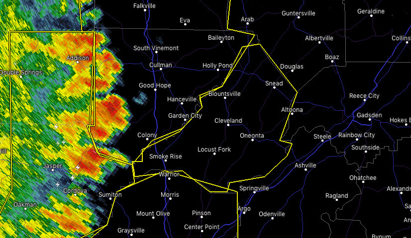

The National Weather Service in Birmingham has issued a
* Severe Thunderstorm Warning for…
Blount County in central Alabama…
* Until 400 AM CDT.
* At 245 AM CDT, severe thunderstorms were located along a line extending from near Sardis to West Jefferson, moving east at 50 mph.
HAZARD…60 mph wind gusts and penny size hail.
SOURCE…Radar indicated.
IMPACT…Expect damage to roofs, siding, and trees.
* Locations impacted include…
Oneonta, Blountsville, Cleveland, Dallas, Warrior, Locust Fork, Altoona, Snead, Susan Moore, Walnut Grove, Trafford, Allgood, Fairview, Hayden, Nectar, Rosa, County Line, McLarty, Bangor and
Strawberry.



