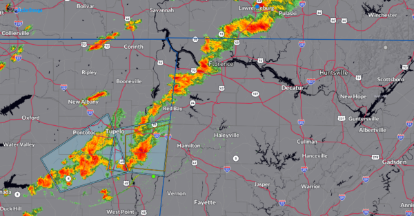
…A SEVERE THUNDERSTORM WARNING REMAINS IN EFFECT UNTIL 730 PM CST
FOR NORTH CENTRAL CULLMAN AND SOUTHWESTERN MORGAN COUNTIES…
At 719 PM CST, a severe thunderstorm was located near Falkville, or 7
miles south of Hartselle, moving east at 60 mph.
HAZARD…60 mph wind gusts and quarter size hail.
SOURCE…Radar indicated.
IMPACT…Hail damage to vehicles is expected. Expect wind damage to
roofs, siding, and trees.
Locations impacted include…
Hartselle, Falkville, Vinemont, Baileyton, West Point, Eva, Fairview,
Cole Springs, Battleground and Lacon.
Severe Thunderstorm Warning Continues For Parts Of Cullman And Morgan Counties Until 730 PM CST
Feb 8th @ 7:06 pm

…A SEVERE THUNDERSTORM WARNING REMAINS IN EFFECT UNTIL 730 PM CST
FOR NORTH CENTRAL CULLMAN AND SOUTHWESTERN MORGAN COUNTIES…
At 719 PM CST, a severe thunderstorm was located near Falkville, or 7
miles south of Hartselle, moving east at 60 mph.
HAZARD…60 mph wind gusts and quarter size hail.
SOURCE…Radar indicated.
IMPACT…Hail damage to vehicles is expected. Expect wind damage to
roofs, siding, and trees.
Locations impacted include…
Hartselle, Falkville, Vinemont, Baileyton, West Point, Eva, Fairview,
Cole Springs, Battleground and Lacon.
Severe Thunderstorm Warning Canceled For Parts Of Lawrence County until midnight CS
Feb 8th @ 7:06 pm
…THE SEVERE THUNDERSTORM WARNING FOR SOUTHEASTERN LAWRENCE COUNTY
IS CANCELLED…
The severe thunderstorm which prompted the warning has moved out of
the warned area. Therefore, the warning has been cancelled.
A severe thunderstorm watch remains in effect until midnight CST for
north central, northeastern and northwestern Alabama.
Severe Thunderstorm Warning Issued For Parts Of Cullman, Lawrence, And Morgan Counties Until 730 PM CST
Feb 8th @ 7:06 pm

The National Weather Service in Huntsville Alabama has issued a
* Severe Thunderstorm Warning for…
Northwestern Cullman County in north central Alabama…
Southwestern Morgan County in north central Alabama…
Southeastern Lawrence County in northwestern Alabama…
* Until 730 PM CST
* At 705 PM CST, a severe thunderstorm was located over Inmanfield,
or 14 miles north of Arley, moving east at 55 mph.
HAZARD…60 mph wind gusts and quarter size hail.
SOURCE…Radar indicated.
IMPACT…Hail damage to vehicles is expected. Expect wind damage
to roofs, siding, and trees.
* Locations impacted include…
Hartselle, Falkville, Sardis, Vinemont, Baileyton, West Point, Eva,
Fairview, Cole Springs and Battleground.