


…A SEVERE THUNDERSTORM WARNING REMAINS IN EFFECT UNTIL 200 AM CDT FOR MARION COUNTY… At 148 AM CDT, severe thunderstorms were located along a line extending from Belgreen to near Brilliant, moving east at 50 mph.
HAZARD…60 mph wind gusts and penny size hail.
SOURCE…Radar indicated.
IMPACT…Expect damage to roofs, siding, and trees. Locations impacted include… Hamilton, Winfield, Guin, Hackleburg, Brilliant, Glen Allen, Gu- Win, Brinn, Weston, Lake Buttahatchee, Bear Creek, Twin, Tucker, Tessner, Pearces Mill, Rankin Fite Airport, Upper Bear Creek Reservoir, Texas, Pigeye and Marion County Public Lake.
Severe Thunderstorm Warning Issued For Parts Of Marion County Until 2:00AM
Jun 20th @ 1:36 am
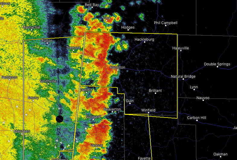

The National Weather Service in Birmingham has issued a
* Severe Thunderstorm Warning for…
Marion County in northwestern Alabama…
* Until 200 AM CDT.
* At 135 AM CDT, severe thunderstorms were located along a line extending from near Red Bay to near Hamilton, moving east at 50 mph.
HAZARD…60 mph wind gusts and penny size hail.
SOURCE…Radar indicated.
IMPACT…Expect damage to roofs, siding, and trees.
* Locations impacted include…
Hamilton, Winfield, Guin, Hackleburg, Brilliant, Glen Allen, Gu-
Win, Weston, Brinn, Lake Buttahatchee, Bear Creek, Twin, Tucker, Rankin Fite Airport, Upper Bear Creek Reservoir, Marion County
Public Lake, Piney Grove, Tessner, Shottsville and Pearces Mill.



