


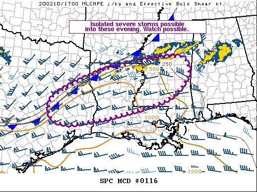
From the SPC: Isolated strong to severe thunderstorms are expected this afternoon into this evening from southeast TX into portions of LA and MS. Damaging winds, isolated hail and a tornado or two are possible. The area is being monitored for potential watch issuance within the next few hours.
In-Depth Discussion: Thunderstorms are increasing in intensity early this afternoon from portions of eastern TX into northern LA and portions of west-central MS. This activity is developing ahead of a surface cold front in a southerly low level warm advection regime. Breaks in higher clouds across the broader region has revealed extensive low level CU field across the warm sector. Surface dew points have increase to the upper 60s to low 70s across the Sabine and lower MS Valley, as far north as the I-20 vicinity in central MS near KJAN, while temperatures have warmed into the 70s across much of the region. As a result, MLCAPE has increased to around 500-1000 J/kg. With continued heating, some additional destabilization is expected.
Effective shear greater than 40 kt will support supercells and bowing line segments capable of strong, locally damaging wind gusts. Steeper midlevel lapse rates reside across parts of central into eastern TX and parts of LA, which could lead to some marginally severe hail in more isolated/discrete cells. Deep layer flow is oriented parallel to the surface boundary, which will result in training convection, while favoring transition of semi-discrete cells to clusters/line segments. Additionally, convection developing near the cold front could quickly become undercut as storm motion brings convection to the cool side of the boundary. In addition to sporadic strong wind gusts, low level shear will be sufficient for rotation. Given rich low level moisture in place, a tornado or two can not be ruled out, especially if any sustained surface-based cells can develop further south of the cold front in the higher-quality warm sector.
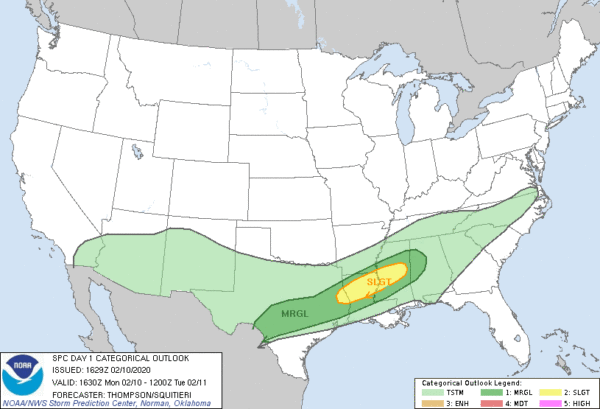
There is a Slight Risk for severe storms over the center of that Mesoscale Discussion outline, along with a Marginal Risk on the outside circumference. Damaging winds up to 60 MPH, isolated hail, and a brief tornado or two are possible through the rest of the day.
Street flooding is not occurring in downtown Birmingham on and just northeast of the campus of UAB. Street flooding is also recorded in Hueytown on 15th Street to Virginia Road and is closed at this point.
Please do not attempt to drive on flooded roadways. There could be hidden dangers under the surface of the roadway that could put you and your vehicle in jeopardy, plus the lives of the rescue workers who would have to come out to attempt to save you. Be smart… Turn around, don’t drown.



