


There is a lot of talk out there about a “bust,” and while forecasts do occasionally fail to pan out like we expect, this one has not even had time to get started yet. The morning sounding (weather balloon) from the Shelby County Airport showed very little atmospheric resistance to thunderstorms; however, the Jackson, Mississippi sounding showed a strong “cap.” A cap is a temperature inversion that prevents air from freely rising into the atmosphere. Here is a modified forecast sounding for Birmingham at 1:00 PM:
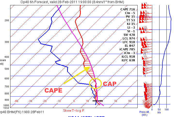
Modified RUC Forecast Sounding for 1:00 PM Today (Birmingham)
There are three things this sounding tells us: one, the inversion over Mississippi is edging into Alabama, but it is not as strong; there is some instability in place; and three, it is going to take some forcing mechanism to actually initiate showers and storms in Central Alabama. . Forcing mechanisms are cold fronts, warm fronts, outflow boundaries, or anything that causes surface wind convergence and upper-air wind divergence. There is a surface cold front near the Mississippi River that should move across Mississippi and come through Central Alabama between 2:00 PM and 6:00 PM. Above and just west of that front in the middle and upper atmosphere, a shortwave (disturbance) is creating divergence aloft, and that promotes upward motion.
So, while the jury is still out as to whether large, violent tornadoes happen (which is something that occurs on such a small scale that we cannot accurately say when & where a single one is likely), some severe weather is certainly a possibility across all of north and central Alabama today. Be alert; we’ll keep the information coming on this end. If nothing happens, nothing happens; but it’s not over yet.
-Jason
Follow me on Twitter: @simpson3340



