Daily Weather Briefing
Sunday, November 1, 2026
ALABAMA THIS MORNING
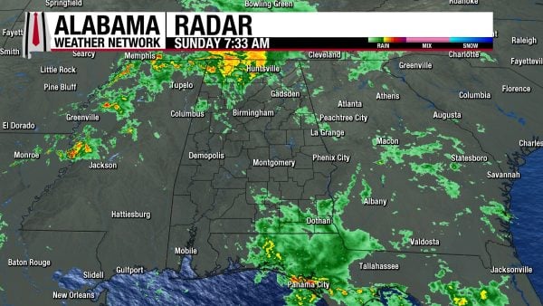
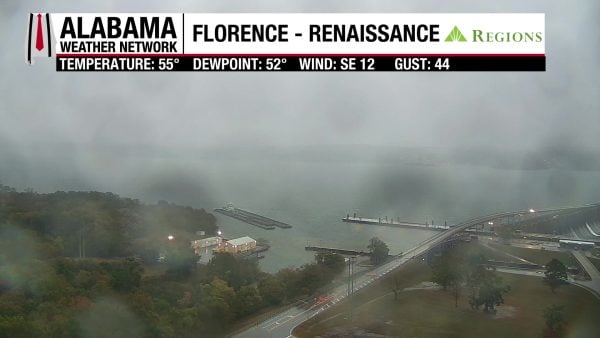
Showers spread across the north as well as the southeast this morning, and temperatures are in the mid to upper 50s in north and north-central Alabama, while the rest of the state is in the low to mid 60s. Skies are cloudy statewide, even where there isn’t rain. Our Regions Skycam at Florence-Renaissance is gloomy and wet, and windy too, with a gust of 44 mph!
ALABAMA 7 DAY FORECAST
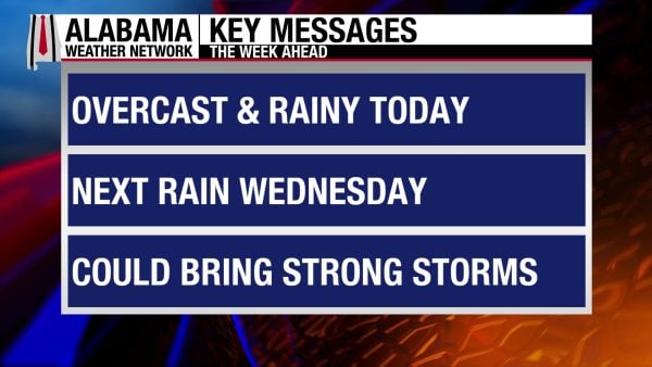
A shortwave trough continues to move through Alabama today, so showers and a few thunderstorms are possible statewide. Upper-level ridging returns tomorrow and Tuesday, and rain chances dwindle before another storm system moves through Wednesday, bringing more rain and thunderstorms to Alabama. As we head into the latter half of the week and into the weekend, conditions will dry.
SCATTERED SHOWERS TODAY – Nov 1
The shortwave trough will keep Alabama under a regime of scattered showers and a few rumbles of thunder, as well as overcast skies today. Highs will range from the mid 60s north, upper 60s to low 70s centrally, and low to mid 70s south. Coastal Alabama will hit the upper 70s. Check out the Rainfall Outlook Section below to see how much rain the state is expecting today. We’ll be windy today also, with wind speeds in the teens and gusts up to 25 mph.
MOSTLY DRY MONDAY AND TUESDAY – Nov 2-3
As mentioned above, an upper-level ridge will build into Alabama early this week, bringing dry and warm conditions back to the state. No rain is expected on Monday, with highs rising into the mid 70s north, mid to upper 70s centrally, and upper 70s to low 80s south. A 10% chance of rain returns to the southern half of Alabama on Tuesday, and highs will be in the mid to upper 70s in the northern half of the state and the upper 70s to low 80s in the southern half.
RAIN AND STORMS ON WEDNESDAY – Nov 4
Showers and thunderstorms return Wednesday as a surface low-pressure system pushes its cold front through the state. Exact timing and potential for severe weather are to be determined, but showers, thunder, and lightning have a 70% chance of occurring in the northern half of the state, and a 60% chance in the southern half. Highs will be in the low 70s north, mid to upper 70s centrally, and mid 70s to low 80s south.
DRYING TREND THURSDAY ONWARD – Nov 5-7
After a rainy Wednesday, a 30% chance of showers lingers in the northern half of Alabama, while a 20% chance sticks around in the south on Thursday. Showers will be isolated in nature, and highs will climb to the low 70s north, mid 70s centrally, and mid 70s to low 80s once again.
Friday will trend slightly drier, with only a 20% chance of showers in the northern half and a 10% chance in the southern half of the state. Highs will be in the low 70s north and upper 70s south.
We’ll be completely dry again by Saturday, and the same range of the low 70s north to upper 70s south is expected.
RAINFALL OUTLOOK
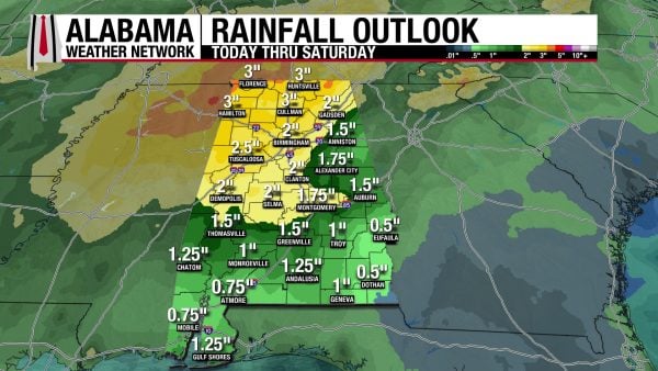
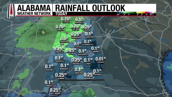
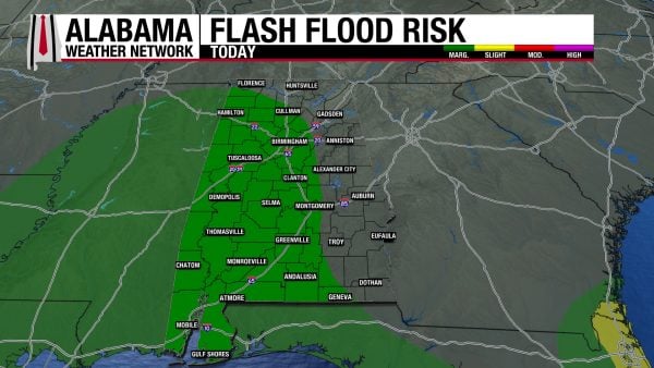
Over the next week, Alabama is forecasted to receive anywhere from 0.5″ of rain to 3, maybe 4″ of rain. The lower bound of this range is expected toward the south, while the higher values are expected in the north. Rain amounts expected today are between a tenth of an inch and three-quarters of an inch of rain; again, those higher values are expected in the north, more specifically the northwest. The western two-thirds of Alabama have been placed under a Marginal Risk (1/4) of flash flooding today, so be careful driving on the roads today.
THE ATLANTIC
There is no tropical activity in the Atlantic.

THE PACIFIC
A broad area of low pressure is forecast to develop well southeast of Hawaii within the next few days. It has a 50% chance of developing into a tropical system over the week.
RAINY TODAY, MORE RAIN THIS WEEK ON COAST
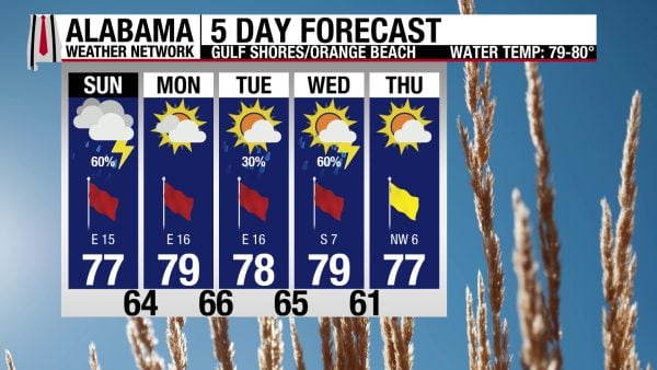
There is a 60% chance of showers and thunderstorms on the coast today. Additionally, the high will be in the upper 70s, skies will be mostly cloudy, and winds will blow from the east at around 15 mph. This will keep the rip current risk high and the surf height between 3 and 5 feet. Tomorrow will be dry before rain returns Tuesday and continues on Wednesday.

WEATHERBRAINS 1085
The OTUS Project team returns to WeatherBrains tomorrow, where they will answer questions and talk about their research, UAVs, sensors, and fieldwork. Listen to the episode wherever you get your podcasts or watch it here!
TODAY IN WEATHER HISTORY
November 1, 2000 – North Dakota Tornadoes and Blizzard
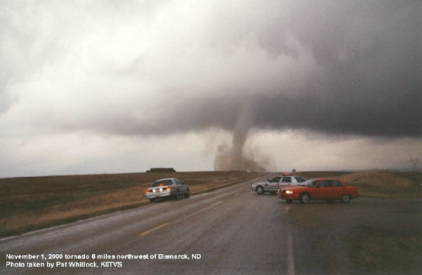
On November 1, 2000, an extraordinary autumn storm brought two dramatically different kinds of severe weather to the Northern Plains, producing tornadoes and blizzard conditions across North Dakota at nearly the same time. A powerful low-pressure system moving northeastward through the Dakotas drew unusually warm, moist air northward while cold air wrapped around its western side. The resulting contrast created an atmosphere capable of supporting rotating thunderstorms in central North Dakota and heavy snow farther west. During the afternoon, five tornadoes touched down around Bismarck and Mandan, becoming the latest tornadoes ever documented in North Dakota. Even more remarkable was their direction of movement. Instead of tracking eastward or northeastward like most Plains tornadoes, these twisters moved toward the west and northwest, carried by the unusual counterclockwise circulation surrounding the intense low-pressure center.
The tornadoes began developing during the early afternoon, with the first warning issued at 2:33 p.m. for a storm approximately seven miles north of Bismarck. Several more warnings followed as rotating thunderstorms moved across the metropolitan area and surrounding countryside. The tornadoes were generally weak, rated F0 and F1 on the original Fujita Scale, with winds estimated as high as 90 mph. Nevertheless, they caused significant localized destruction. One tornado struck northern Bismarck, damaging 42 homes, tearing roofing materials from buildings, and scattering debris across residential streets. Two people suffered injuries. Another tornado tracked across rural areas north of the city, damaging a home and crossing the Missouri River into Morton County. Residents and meteorologists were confronted with an extraordinary scene: tornadoes moving westward in November, a month when North Dakota had never previously recorded a tornado in its modern weather records.
While tornado warnings sounded around Bismarck, winter storm watches and warnings were in effect across western North Dakota. On the cold side of the same powerful cyclone, snow began falling during the afternoon and intensified overnight into November 2. Winds gusting to 50 mph whipped the accumulating snow across highways and open farmland, reducing visibility to near zero. Snowfall totals eventually reached six to fourteen inches in parts of western North Dakota, with extensive blowing and drifting snow closing highways and isolating rural communities. In Bowman County, a tour bus carrying dozens of Canadian travelers overturned on a snow-covered highway during the storm, seriously injuring several passengers. Emergency crews struggled through the dangerous conditions to reach the wreckage. Widespread power outages added to the disruption, leaving residents across northwestern North Dakota without electricity as the storm continued.
The winter storm also battered the Black Hills of South Dakota, where some of the most extraordinary snowfall totals were recorded. In Lead, South Dakota, 31.9 inches of snow fell in a single day, setting a November daily snowfall record. The tremendous accumulation buried streets, blocked driveways, and brought transportation to a standstill. The storm’s sharply contrasting weather conditions reflected the enormous temperature differences surrounding the low-pressure center. Warm, unstable air flowing into its eastern side fueled thunderstorms and tornadoes, while cold air wrapping around the western side supported heavy snow and blizzard conditions. What made the event especially unusual was how closely these hazards occurred to one another, with residents in different parts of the same state experiencing entirely different seasons almost simultaneously.
By November 2, the powerful storm system had moved away, leaving behind damaged homes, stranded travelers, snow-covered highways, and communities beginning the difficult process of recovery. The five North Dakota tornadoes established a remarkable state record, surpassing the previous latest tornado date of October 11, 1979. The unusual westward movement of the tornadoes also provided a striking example of how storms can behave differently when developing near the center of a strong low-pressure system. Meanwhile, the heavy snow and destructive winds demonstrated that winter could arrive suddenly and violently across the Northern Plains. For meteorologists, November 1, 2000, remains one of the most unusual weather days in North Dakota history, when tornadoes and blizzard conditions developed within the same powerful storm system. It was an extraordinary reminder that the atmosphere does not always respect the boundaries between seasons, and that a single November storm can deliver the hazards of both spring and winter.
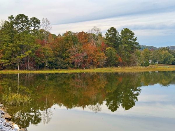
IMAGE OF THE DAY
Skywatcher Joey Amberson sent in this beautiful photo from Neely Henry Lake in Ashville yesterday!