


Daily Weather Briefing
Sunday, July 26, 2026
ALABAMA THIS MORNING
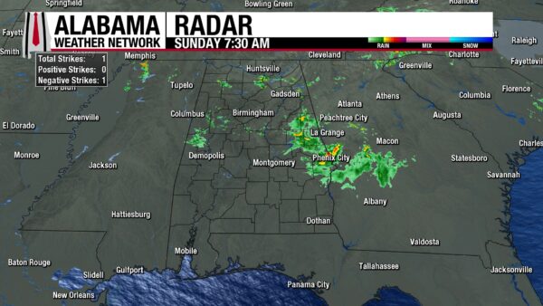
Some light to moderate showers stretch across portions of Alabama this morning. Toward the area where Franklin, Lawrence, Marion, and Winston Counties meet, a shower is present. Then further east, showers stretch across northwest Cullman, south Morgan, Marshall, and north Blount Counties. A few showers sit over DeKalb and Cherokee Counties this morning as well. Heading to the southwest, showers sit over Pickens, Sumter, Greene, and Tuscaloosa Counties. Lastly, a much larger swath of showers stretches from Clay and Randolph Counties south into Barbour County. Otherwise, Alabama is dry, and skies are cloudy across most of the northern half of the state. Northwest and south Alabama, however, are partly cloudy to mostly sunny. Temperatures sit in the mid to upper 70s statewide.
ALABAMA 7 DAY FORECAST
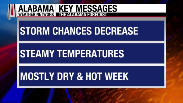
Showers and thunderstorms will be scattered again today with less coverage expected. This week we will sit on the eastern edge of an upper-level ridge to the west that will keep us hot and mostly dry through Wednesday. Then an upper-level trough to the east begins to dig into the Eastern U.S., and as we sit on its western edge, it will bring highs and rain chances back to normal. There is a low chance for a storm complex to push through Alabama Monday, but quite a few uncertainties exist with this portion of the forecast.
STORM COVERAGE SCATTERED TODAY – July 26
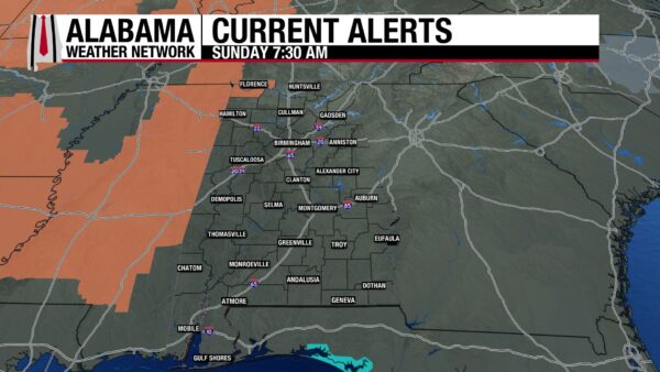
Any showers and thunderstorms that develop today will be more scattered in nature, especially compared to yesterday. Rain has already begun in the northern half of the state and into south-central Alabama. It will continue in the northern half of the state through the morning, then push southward through the day, bringing rain to the southern half of the state in the afternoon. Because of this, the northern half of the state should be mostly dry this afternoon. Highs will hit the low 90s in the northern half of Alabama and the low to mid 90s in the southern half. Additionally, a Heat Advisory is in effect for Lauderdale and Colbert Counties from 11 a.m. to 7 p.m. with heat indices up to 106 degrees expected.
HEAT TURNS ON THIS WEEK – July 27-29
The upper-level ridge to the west will really start to put on the charm for Alabama starting tomorrow. It will bring rain chances to 20% statewide and highs to the mid 90s north, mid to upper 90s centrally, and upper 90s in the south. Heat indices will range from 100-109, even higher in some spots, but the heat could be impacted by a potential storm complex that might move through the state tomorrow. Confidence in this occurring is low for now.
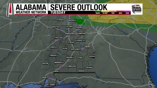
Tuesday seems like it will turn out to be the hottest day of the week. Rain will be difficult to find, with maybe a quick isolated storm here and there in the afternoon. Highs will reach the upper 90s to around 100 degrees statewide, with any 100-degree readings sticking to the southern two-thirds of the state. Feels-like temperatures will easily hit the 105–109-degree range over most of the state as moisture stays elevated throughout the week. If any storms do develop in northeast Alabama, there is a Marginal Risk (1/5) that they become severe and produce damaging winds and frequent lightning.
It will be slightly less hot on Wednesday as highs range from the lower 90s north, the mid 90s centrally, and mid to upper 90s south. Feels-like temperatures will still sit in the 100-109-degree range. Low to medium rain chances return in the northern half and southern half of the state, respectively.
SLIGHTLY LESS HOT TO END THE WEEK – July 30-Aug 1
The upper-level trough to our east will win out on influencing Alabama over the ridge by Thursday. Highs will only reach the low to mid 90s from north to south on Thursday and rain chances will be isolated to scattered over the state.
Friday’s highs will also be in the low to mid 90s from north to south, but rain chances will be slightly more isolated.
The low 90s will dominate Alabama on Saturday as we welcome a new month, and rain chances will be low to medium in the northern half and southern half of the state, respectively.
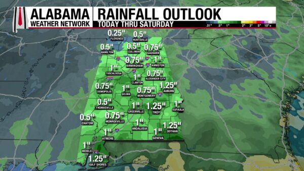
RAINFALL OUTLOOK
Rainfall accumulations statewide will be relatively uniform over the next week, with most of the state expecting three-quarters of an inch to an inch of rain. North Alabama could see slightly less, ranging from only a quarter to three-quarters of an inch, and a few locations in the southern half of the state may receive an inch and a quarter of rain. No flash flood outlooks exist over the next few days as rain will be harder to find and short-lived.
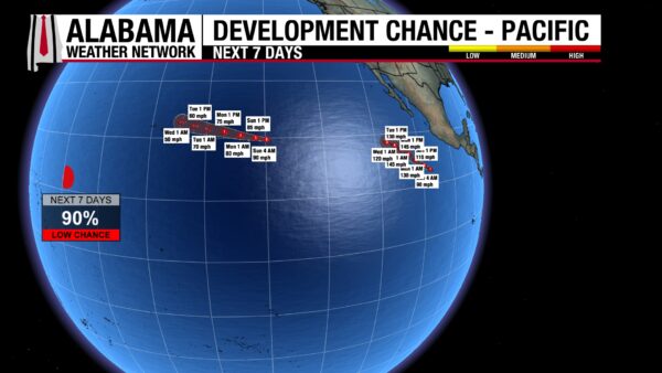
TWO HURRICANES AND AN AREA TO WATCH IN PACIFIC
Hurricane Fausto and Hurricane Genevieve both sit at Category 1 status this morning, with Fausto’s central pressure at 974 mb and Genevieve’s at 980 mb.
Hurricane Fausto moves west at 13 mph and is forecast to move northwest as it weakens into a tropical storm by Tuesday morning. Its forecast track has shifted mostly north of Hawaii, keeping most rain and wind impacts north of the state as well. However, there is still plenty of time for the storm’s track to change again, so guards should not be let down. Additionally, surf and waves will get rough this week.
Hurricane Genevieve moves west-northwest at 17 mph and is rapidly intensifying. It is expected to become a major hurricane (Cat 3 or greater) later today. No land is in the storm’s path, and it is expected to be a major hurricane until Wednesday, when it will weaken to a Category 1 or 2 storm.
The National Hurricane Center also has an eye on the area of low pressure that is well southwest of Hawaii that now has a 90% chance of tropical development. The system is anticipated to develop into a tropical system today or tomorrow as it continues to organize.
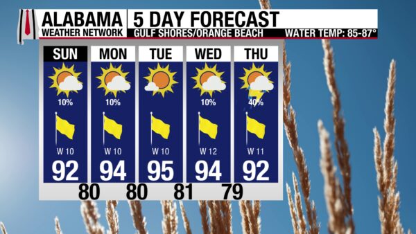
GORGEOUS BEACH WEATHER MOST OF THE WEEK
Today through Wednesday features excellent weather that involves a high in the low to mid 90s, mostly sunny skies, an Extreme UV Index, and winds from the west at 10-15 mph. Rain chances stay at a 10% chance of an afternoon thunderstorm, with Tuesday expecting no rain. The waters stay calm today with a Low rip current risk and a surf height of 2 to 3 feet. This risk increases to Moderate Monday but falls back to Low Tuesday. By Thursday, Alabama beaches have a 40% chance of afternoon thunderstorms to keep an eye on.
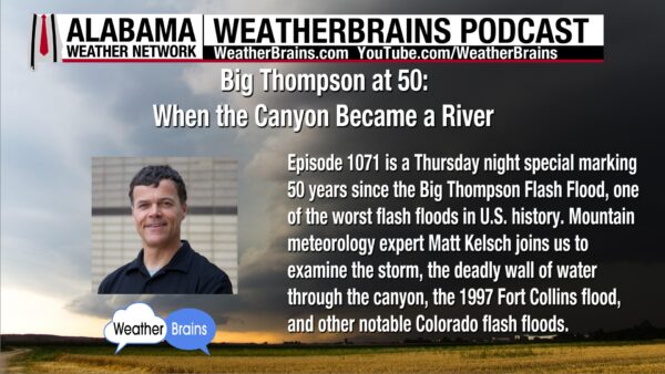
WEATHERBRAINS 1071
Tomorrow’s episode features Mountain meteorology expert Matt Kelsh to talk about the 50th anniversary of the Big Thompson Flash Flood. The episode was recorded Thursday as James Spann takes a vacation this week. Listen wherever you get your podcasts or watch the episode here.
TODAY IN WEATHER HISTORY
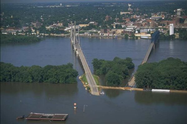
July 26, 1993 – Great Mississippi River Flood of 1993
By July 26, 1993, the Great Flood was no longer just a high-water event. It had become a long disaster across the central United States. The Mississippi and Missouri rivers and their tributaries had been rising, falling and rising again for months, wearing down levees, towns, farms and nerves across the Midwest.
The setup had begun long before the worst crests arrived. A wet fall in 1992 left soils saturated across parts of the basin. Then spring and summer 1993 brought repeated rounds of storms over the same areas. Instead of soaking into the ground, new rain ran quickly into streams and rivers. Parts of the Upper Midwest received more than 4 feet of rain during the season, and by midsummer, the river system was carrying more water than communities and levees could handle.
The scale was enormous. Major flooding spread across North Dakota, South Dakota, Nebraska, Kansas, Minnesota, Iowa, Missouri, Wisconsin and Illinois. Hundreds of river forecast points climbed above flood stage, and many reached record levels. Along the Mississippi and Missouri, levees failed or were overtopped, allowing water to pour across farmland, roads and towns.
Across the Midwest, transportation was disrupted for weeks. Barge traffic on the Mississippi and Missouri rivers was halted. Bridges were closed or cut off by water. Roads, rail lines and airports were flooded, and normal movement through the region became difficult or impossible in some corridors. Flood fighting became a daily routine, with residents, National Guard units, volunteers and emergency crews stacking sandbags and watching river gauges.
At St. Louis, the Mississippi River was still rising on July 26. The city’s floodwall held, but only narrowly. Less than a week later, on August 1, the river crested at 49.58 feet, nearly 20 feet above flood stage and the highest level ever recorded there. The floodwall, built to handle the great 1844 flood, kept the water out of downtown St. Louis with just over 2 feet to spare.
By the time the flood finally receded, the numbers were staggering. More than 20 million acres had been inundated across nine states. About 54,000 people were evacuated, around 50,000 homes were damaged or destroyed, and losses were estimated at $15 to $20 billion. The Great Mississippi River Flood of 1993 tested and sometimes defeated communities protected by levees and floodwalls.

IMAGE OF THE DAY
Skywatcher Daniel Harbin took this wonderful photo of the sunrise above the cloud deck in Trenton this morning!



