


We continue to be in a rather progressive weather pattern across Alabama and the rest of the United States. This means rain every 4-5 days, something we can use.
SATURDAY RAINS: rainfall amounts across Central Alabama were mostly light on Saturday. The exception was West Central Alabama’s Sumter, Greene, Hale, and Marengo counties, where over an inch fell in spots.
FOR YOUR SUNDAY: The cold front is near the Northwest corner of Alabama early this morning. The front should reach I-59 by early afternoon. Rain showers will continue ahead of the front until it passes. Skies will begin to slowly clear a few hours after the front. Highs this afternoon will range from56-57F along the US-278 Corridor to near 60F along the I-20 Corridor to lower to middle 60s over South Central Alabama. The airmass behind the cold front will not be dramatically colder. Lows tonight will drop into the 30s north of I-20, with 40s to the south.
FRESH BATCH OF COLD AIR: The eastern trough will be strengthened on Monday as an upper-level disturbance carves it out a little more. This will power a secondary cold front that will push through the area late on Monday. Before it arrives, skies should clear early and with abundant sunshine, highs will warm into the middle 50s. Most spots should go below freezing Monday night and readings will remain in the 40s all day Tuesday.
MIDWEEK MODERATION: Warmer air will begin flowing into the area Wednesday, allowing highs to return to the middle 50s for the most part. Here are ten day temps from the GFS:
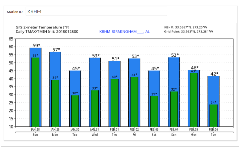
NEXT SYSTEM: Another front will bring a round of rain showers to Alabama Thursday night into Friday morning. With no instability, no thunder is expected. Rainfall amounts should be light, less than 0.25 inches. Friday temperatures will hover near the morning lows in the middle 40s, but the precipitation should be gone before enough cold air invades to produce frozen precip.
COOL WEEKEND: Readings will be below freezing Saturday and Sunday. Highs will hold tough in the 40s Saturday but return to the 50s for Sunday.
MODEL DIFFERENCES: The GFS clears things out quickly on Friday and keeps us dry through the weekend. The Euro is quite different, stalling the front across the area and keeping showers in the forecast. We will have to wait and see.
GULF COAST WEATHER: GULF COAST WEATHER: Rain and storms will move out later today along the beautiful beaches of Alabama and Northwest Florida. It will remain dry and cool into midweek, but rain will return late Thursday, Friday and Saturday. Highs into the weekend will be in the upper 50s and middle 60s. Water temperatures are around 52F.
Click here to see the Beach Forecast Center page. Save Up To 25% on Spring Break Beach Vacations on the Alabama Gulf Coast with Brett/Robinson! The Beach Forecast is partially underwritten by the support of Brett/Robinson Vacation Rentals in Gulf Shores and Orange Beach. Click here to see Brett/Robinson’s best beach offers now!.
WEATHERBRAINS: This week, the panel will entertain Dr. Rick Knabb from The Weather Channel. Check out the show at www.WeatherBrains.com. You can also subscribe on iTunes. You can watch the show live at live.bigbrainsmedia.com. You will be able to see the show on the James Spann 24×7 weather channel on cable or directly over the air on the dot 2 feed.
ON THIS DATE IN 1977: The Winter of 1976-77 had been a brutal one in Buffalo, New York. It was the coldest January ever in Buffalo, as well as the coldest on record for the eastern half of the country. In a city that is known for handling snow well, 28 straight days of snow had left 33 inches on the ground and even the hardiest Buffalo residents grumbling. On this date, the Great Buffalo Blizzard started like many other snow squalls from Lake Erie.
It was Buffalo’s worst blizzard ever, but the 12 inches of snow that fell during the 3-day storm was not the story. Much more impressive snowfalls have buried the city, including a monstrous 7-foot snowfall in 5 days in December 2001. But during this storm, strong northwest winds gusting to 60 mph lifted up the snow piled on frozen Lake Erie and blasted the city with it. People were trapped wherever they were, in their cars, homes, or offices.
Nine people froze to death in their stranded automobiles. Snow drifts up to 25 feet high buried homes and buildings and allowed two reindeer from the Buffalo Zoo to walk over their fences. Wind chills dropped to –50 degrees. Damages totaled $250 million.
It was the first snowstorm to receive a Federal disaster declaration. Snow eventually would fall on 43 consecutive days. Follow my weather history tweets on Twitter. I am @wxhistorian at Twitter.com.



