RADAR CHECK: Scattered showers are moving across Alabama early this morning; nothing heavy, no thunder. The sky will be generally cloudy across the Deep South today with occasional showers… a few thunderstorms are possible this afternoon and tonight as a surface front drops southward. Instability is not especially high, and wind fields are weak, so severe thunderstorms are not expected. Maybe a storm with small hail over the central counties this afternoon and early tonight. The high today will be in the 66-76 degree range.
Showers and a few storms will linger over South Alabama tomorrow morning, but all of the rain should be gone by midday.
THE ALABAMA WEEKEND: Most of the weekend will be rain-free; just a slight risk of a shower Saturday over the southern half of the state. Partly sunny days, fair nights, and highs in the 70s.
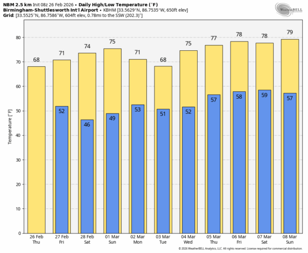
A strong upper high will form along the south Atlantic coast next week, and this will keep the big rain producers west and north of Alabama. Most of the week will be dry with only a few isolated showers around Thursday and Friday. Highs will be in the upper 60s and low 70s Monday and Tuesday, then rising into the 73-83 degree range over the latter half of the week. See the video briefing for maps, graphics, and more details.
ON THIS DATE IN 2008: A long-lived windstorm produced by severe thunderstorms, known as a derecho, caused a widespread swath of damage across Central Alabama during the early morning hours. Although there were some sporadic reports of light tree damage and small hail west of I-65, a more intense and widespread swath of damage started in southern Jefferson and northern Shelby Counties between 3:30 am and 4:00 am. From there, the damage swath moved eastward, roughly parallel to Interstate 20, reaching the Georgia border by 5:00 am. Thunderstorm wind gusts estimated at 60 to 70 mph were widespread in this damage swath, with occasional hurricane force peak wind gusts, estimated just over 100 mph in some areas. The system also was responsible for three EF-1 tornadoes.
I won’t be able to produce an afternoon video briefing today due to travel, but I will post forecast notes by 3:00. Enjoy the day!