FOGGY START: We have a dense fog advisory for roughly the southern half of Alabama this morning where visibility is limited, and there is also some scattered drizzle. We expect the sun to break out later today with afternoon highs in the 60s and low 70s. In addition to the morning drizzle, there could be a couple of small, isolated showers this afternoon, but most places will be dry.
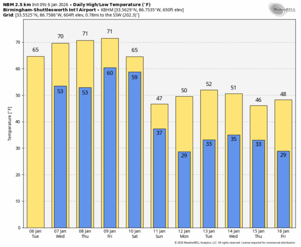
The weather stays very mild tomorrow and Thursday with highs reaching or exceeding 70 degrees for most of the state. Any showers will remain small and isolated.
FRIDAY FRONT: An approaching cold front will bring an organized band of showers and thunderstorms into the state Friday afternoon through Saturday. SPC maintains a risk of severe storms for the northwest corner of Alabama Friday afternoon/night…
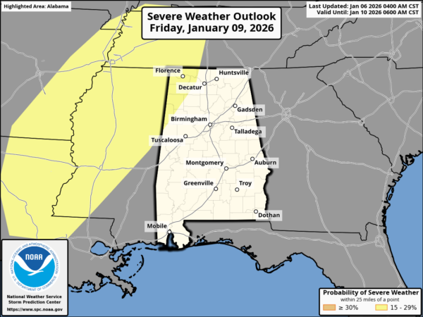
The better dynamic support will be lifting away from the Deep South, but the air will be somewhat unstable so a storms could produce strong gusty winds, but for now the overall severe threat looks fairly low. Rain and storms will end from the northwest during the day Saturday as colder, drier air begins to arrive. Temperatures Saturday will range from the 50s over the Tennessee Valley to the low 70s across South Alabama.
Sunday will be dry and colder; with a sunny sky highs will range from 45-55 degrees. A freeze is likely for much of the state by Monday morning.
NEXT WEEK: For now most of the week looks dry with seasonal temperatures; highs in the 40s and 50s, lows in the 20s and 30s. See the video briefing for maps, graphics, and more details.
ON THIS DATE IN 1988: A multiple day winter storm was underway; it brought snow to the northern half of Alabama, with Huntsville receiving 9.6″. Other totals included 9.1″ at Guntersville, 9″ at Moulton and Scottsboro, 8″ at Athens and Fayetteville, 7″ at Fort Payne, 6.5″ at Falkville, 6.3″ at Russellville, 6″ on Sand Mountain at Crossville, 5.5″ at Hanceville, 5″ at the Muscle Shoals Airport, and 2.5″ in Cullman.
ON THIS DATE IN 2017: Much of Central Alabama received a mixed bag of wintry weather. This weather ranged from freezing rain to sleet to snow. The heaviest accumulations of sleet and snow occurred mainly near and south the Interstate 20 corridor. The highest amounts were observed in Tuscaloosa and Jefferson Counties, where up to 1.5 inches of sleet and snow fell.
Look for the next video briefing here by 3:00 this afternoon… enjoy the day!