


RAIN RETURNS TONIGHT: Most of Alabama will be dry today… with a partly sunny sky expect a high in the low to mid 80s this afternoon. Any afternoon showers will be few and far between. Tonight an organized band of showers and storms will arrive; SPC has defined a “marginal risk” (level 1/5) of severe thunderstorms for the western third of Alabama… there is a “slight risk” (level 2/5) near the Mississippi border.
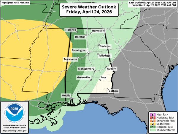
Some of the storms in West Alabama early tonight could produce strong, gusty winds… but they should weaken as they move deeper into the state. With limited instability and dynamic support, the overall severe threat is not especially high, and a tornado threat is not expected.
THE WEEKEND: Rain will diminish quickly early tomorrow morning, and much of the day will be dry. However, a few widely scattered showers and thunderstorms are possible during the afternoon hours. Sunday will be partly sunny and warm with only a very small risk of a shower. The high tomorrow will be in the 75-82 degree range… low to mid 80s are likely Sunday afternoon.
NEXT WEEK: Monday looks warm and dry with highs in the 80s. Then, a period of unsettled weather is likely with some risk of showers and thunderstorms on a daily basis Tuesday through Friday. The air will be very unstable, and we could very well have a day or two with a severe thunderstorm threat, but it is simply too early to know which day will offer the highest risk of strong/severe storms. See the video briefing for maps, graphics, and more details.
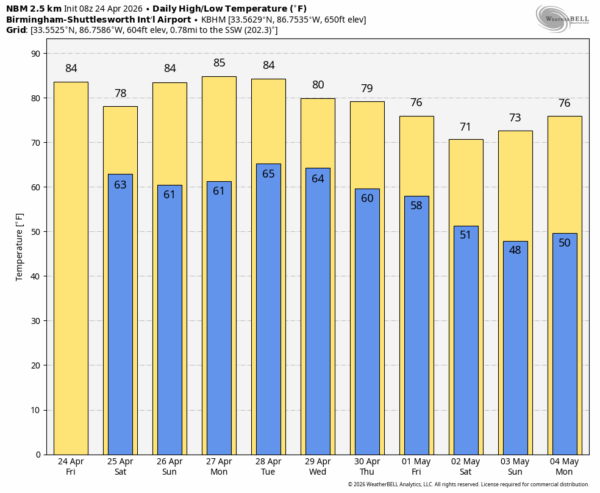
RACE WEEKEND: Today will be warm and dry in Talladega with a high in the low 80s. Periods of rain are likely late tonight and early tomorrow, but most of the day tomorrow will be rain-free with just a few isolated showers around during the afternoon hours. And, Sunday will be warm with only a very small risk of a shower. The high Saturday will be in the upper 70s, followed by low to mid 80s Sunday.
ON THIS DATE IN 1908: At least 34 tornadoes touched down generally east of the Mississippi River from April 23 through April 26, 1908. These tornadoes generally occurred from Texas to Georgia, then northward from Oklahoma to Tennessee. The violent storms killed at least 320 people and injured over a thousand citizens.
On April 24, 1908, a long track tornado, estimated at F4 strength, moved from near Dora (Walker County) to near Sylvania (DeKalb County) around 410 pm.
This tornado may have been associated with a family of tornadoes or was one single path. The estimated single tornado damage path would be at least 100 miles long. A total of 35 people were killed along the path; hardest hit communities were Dora, Warrior, and Albertville. A nine ton oil tank was reportedly carried around one half of a mile near Albertville.
ON THIS DATE IN 2010: A series of tornadoes moved through Alabama, including an EF-3 that was down for 41 miles through parts of Blount and Marshall counties. The most significant and widespread damage along the path occurred in the city of Albertville. Damage to numerous residences, the Albertville high school, and several large retail buildings occurred. Extensive tree damage was also observed throughout the damage path. In the town of Geraldine, numerous large trees were snapped or uprooted which also led to some structural damage to residences.
Look for the next video briefing here by 3:00 this afternoon… enjoy the day!



