The next ten days promises to be a wet period across Alabama as an unsettled pattern settles in over the southeastern United States. Get all the details on the Weather Xtreme Video here:
Here are a few notes in case you don’t have time to watch the video:
SUNDAY SHOWERS: A few light showers are showing up on the radar this morning mainly in and across the I-59 Corridor as a fairly strong shortwave moves by to our north and stronger winds aloft shake out a little precipitation. Temperatures are near 50F to start the day and will rise into the middle and upper 50s over the northern half of the area and lower 60s to the south. Rainfall amounts will be light, generally less than one-tenth of an inch. You will notice some gusty winds at times.
CHRISTMAS EVE: Surface high pressure builds in, giving us ample sunshine and cool temperatures mainly in the middle 50s.
CHRISTMAS DAY: Expect mainly sunny and mild conditions even as a few showers start breaking out to our west. They could edge into Northwest Alabama, but much of Central Alabama remains dry for the day.
WEDNESDAY: Boxing Day (in Australia, the U.K., and Canada) otherwise known as the day we box all the presents we didn’t want to take back to the store, will be decent in Alabama. A few showers could be over the Northwest again, but Central Alabama should be dry and mild with highs in the lower 60s.
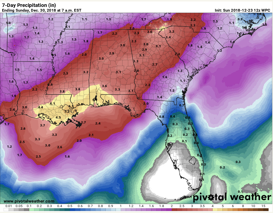
INTO THE POOL: We will be wet starting on Thursday as the retreating surface high works in conjunction with a deepening trough over the Southwest to produce widespread rain (and some thunder) over much of the South. There is high confidence that there will be 2-3 inches of rain across Alabama starting Thursday during the day and continuing into Friday morning. A cold front moves through during the day Friday ending the rain from the Northwest and giving Auburn fans improving conditions in Nashville for the Music City Bowl. It should be dry Friday night with lows in the 40s.
MUSIC CITY FORECAST: Auburn fans should encounter clearing skies and game time temperatures in the lower 60s, falling into the 50s during the game. Not bad.
WEEKEND: Rain returns pretty quickly on Saturday night however and Sunday as the cold front tries to come back northward as a warm front.
ORANGE BOWL FORECAST: Nice run up to and during the Orange Bowl game with warm (80s by day, upper 60s by night) temperatures, a breezy southeast wind, and just a few scattered showers.
NEW YEARS IN ALABAMA: New Year’s Eve looks wet. Period. All day, and all night. Another 1-2 inches of rain. New Years Day looks wet and potentially stormy with some chance of severe weather.
SNOW FANS: The GFS does hint at some light snow on the back side of the departing system from New Year’s. Could it happen? Plausible, just too early to tell. Could there be impacts? Way too early to tell. Will the schools be closed? I can say most schools will be closed on the 3rd. (It’s still Christmas Break for most.) Sorry, couldn’t resist! Stay tuned though.
RAINFALL FORECAST: Rainfall amounts should total 2-3 inches by next Sunday. Here are amounts from the Weather Prediction Center:
WEATHERBRAINS: Great chat with Authr Gary Fine, Jim Stefkovich and Keith Stellman on the current episdode of WeatherBrains. We will look back at 2018’s weather on the show that will be released Tuesday morning of this week. A little Christmas present from us here at WeatherBrains!
I’ll have a forecast update at noon. Not many changes expected. Have a great day.