


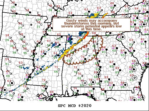
The latest Mesoscale Discussion from the Storm Prediction Center shows a very small risk of severe storms over portions of Central Alabama and has the odds of a new watch being issued very low, at 5%. However, we need to continue to stay weather aware throughout the next several hours across the area. Here is the text from the latest discussion:
SUMMARY… Locally gusty winds may accompany thunderstorms across parts of central AL into northwest GA this morning. However, severe thunderstorm potential is expected to remain limited.
DISCUSSION… A line of strong storms extends from north-central AL into east-central MS this morning ahead of an eastward-advancing cold front. WW 562 is in effect for portions of northern AL, however, severe potential appears low to the south and east of the watch across parts of central AL and northwest GA. Strong deep-layer southwesterly flow will continue to support fast moving cells within the line of convection amid weak instability. This could allow for locally gusty winds to move across the MCD area over the next few hours. However, the 12z BMX RAOB and experimental RAOBs from the University of Alabama – Huntsville indicate a somewhat hostile midlevel thermodynamic environment with weak capping between 850-700 mb. Additionally, midlevel lapse rates remain poor across the region. This will largely limit more intense convection and a new watch is not expected at this time.



