


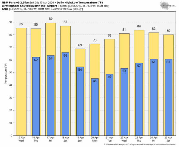
STILL WARM, STILL DRY: Alabama’s weather won’t change much through Friday with partly to mostly sunny, warm days and fair pleasant nights. There is a very small risk of a shower tomorrow afternoon over the western half of the state, but odds of any one spot seeing rain are under 20 percent. Afternoon highs hold in the 80s… some spots could reach the 90 degree mark Friday afternoon.
WEEKEND FRONT: The day Saturday will be dry and warm with a high between 85 and 90 degrees. But we will bring in a chance of showers and a few thunderstorms Saturday night into Sunday morning as a cold front moves through. No risk of severe storms with the main upper support far to the north, and unfortunately rain amounts will be light. Some Northwest Alabama communities could see up to 1/2 inch, but amounts will be a quarter inch or less for most places. Many places across South Alabama won’t see enough rain to measure Sunday as the rain fades away during the afternoon.
Sunday will be much cooler with highs in the 65-70 degree range over the northern half of the state.
NEXT WEEK: The weather will be dry and pleasant during the first half of the week, but we continue to see signs of a pattern change that will bring a good chance of rain and thunderstorms by Friday and Saturday (April 24-25)… too early to know if there will be any severe weather risk. See the video briefing for maps, graphics, and more details.
ON THIS DATE IN 2011: The “forgotten” tornado outbreak of April 15, 2011. Out of the 46 confirmed tornadoes on that day across Alabama, the total damage path length was over 250 miles, with 10 of those tornadoes having damage paths over 10 miles long. The event was “forgotten” by many due to what would happen 12 days later, on April 27, 2011, when a generational tornado outbreak would kill 252 people in our state.
One of the large EF-3 tornadoes to strike Central Alabama on the day created a swath of damage from northeastern Greene County, just southeast of the community of Ralph, to just south of Veterans Memorial Parkway just east of Tuscaloosa in south-central Tuscaloosa County. Winds with this monster were estimated at 140 MPH, mainly uprooting and snapping trees. A few homes and businesses received damage as the twister moved north of Shelton State Community College and crossed Alabama Highway 69 near Taylorville, and crossing I-20/59 near Alabama Highway 82.
For years, the official tornado count stood at 45 on April 15, 2011. However, earlier this year the National Weather Service confirmed a 46th tornado in Greene County near Forkland (EF-2) following a re-examination of historical data and citizen reports.
No afternoon video briefing today due to travel, but I will post fresh forecast notes here by 4:00 p.m. Enjoy the day!



