


An all new edition of the ABC 33/40 Weather Xtreme video is available in the player on the right sidebar of the blog. You can subscribe to the Weather Xtreme video on iTunes by clicking here.
Producing the video and the discussion a little early today to accommodate a 2:00 weather program at Brookwood Forest Elementary School in Mountain Brook. On days like this I prefer to be early instead of late with the products… got a good look at the 12Z guidance for this package.
RIGHT NOW: Our surface low is a little more to the north than forecast by the models; near New Orleans late this morning. Widespread rain continues over North Alabama, with a break in the rain down south where a dry slot has worked into South Alabama. We will continue a good chance of rain around here through the evening hours.
TONIGHT: Remember, the snow event tonight and early tomorrow is mainly associated with forcing with the upper trough, not the surface low. Everything is still on track for a change from rain to snow for North Alabama tonight, but now that we are looking this system in the eyes, a displacement of the surface and upper air features to the north will mean an adjustment to the snow accumulation potential graphic…
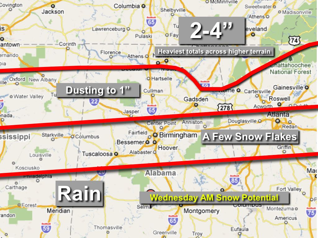
We have pretty much shifted the ole red lines northward… best chance of the 2-4 inch snow amounts now will be over extreme North Alabama, especially near the Tennessee border, and mainly across higher terrain.
For the I-20/59 corridor (Birmingham, Tuscaloosa, Anniston, Gadsden), some light accumulation is possible in grassy areas, but don’t expect too much. And, as we have discussed here for the past 24 hours, we expect the roads to be wet, and not icy, with surface temperatures expected to remain above freezing throughout the event. Most folks should go to work and school tomorrow with no disruption; with possible exceptions coming up on the Northeast Alabama mountaintops.
The best chance of snow will come from about 2:00 a.m. until 10:00 a.m., and the snow should begin initially over Northwest Alabama around Muscle Shoals close to midnight. Even up in the Tennessee Valley most of the snow accumulation will be on grass, with roads remaining just wet.
But, I firmly believe we have more traffic accidents with one inch of rain compared to one inch of snow, so even with wet roads still take it easy out there tonight and tomorrow morning.
We should reach the low to mid 40s tomorrow afternoon, so where snow does accumulate on the grass; it won’t last long. Nothing like the big event two weeks ago that had North Alabama shut down for 3 to 5 days.
REMEMBER: While things look pretty clear cut now, events like this tend to offer surprises. Sometimes big ones. Stay tuned for more possible changes in the forecast as we continue to get a good look at this system on the maps.
THURSDAY THROUGH THE WEEKEND: Some really nice mid-winter weather here. The high Thursday will be close to 50, and we go into the mid 50s Friday through Sunday with a good supply of sunshine each day through scattered clouds. Early morning lows will be mostly in the 30s.
NEXT WEEK: Snow lovers remain focused on the potential Ground Hog Day storm Wednesday of next week; the 12Z GFS remains bullish on winter weather mischief with a surface low roaring out of the Gulf of Mexico, and Polar air invading the state from the north. But, we all know this is still voodoo since the event is still 8 days away. But, you have to be amazed by the consistency of the good ole GFS on this one.
WEATHER BRAINS: Don’t forget you can listen to our weekly 30 minute netcast anytime on the web, or on iTunes. This is the show all about weather featuring many familiar voices, including our meteorologists here at ABC 33/40. Scroll down for the show notes on this week’s new episode.
FOLLOW ALONG: Here are our weather team Twitter accounts….
| James Spann | Jason Simpson | Ashley Brand |
| J. B. Elliott | Bill Murray | Brian Peters |
| Dr. Tim Coleman | WeatherBrains Podcast | E-Warn (AL wx watches/warnings) |
We will have fresh updates through the rest of the afternoon and tonight… so stay tuned. The next Weather Xtreme video will be posted here by 7:00 a.m. tomorrow…



