


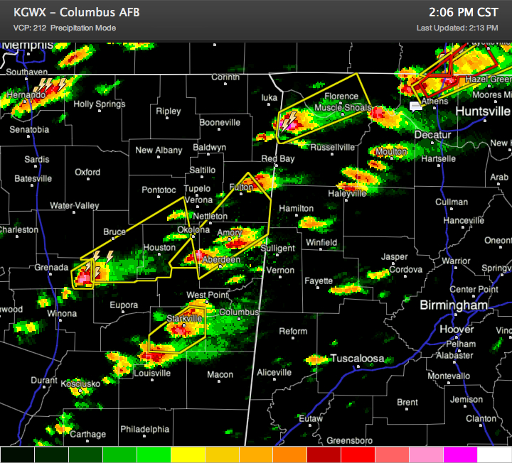
This is a composite reflectivity view of the Columbus MS radar at this hour. It adds up all the radar returns from the various tilts, showing the overall strength of the storms aloft and close to the surface. If you look as a lower single tilt, they don’t look so mean, but the composite look lets you all the precipitation (rain and hail) that it being stored aloft.
As you can see, storms over eastern Mississippi and northwestern Alabama are getting quite mean now.
A possible tornado is near I-65 north of Athens AL about to cross into Tennessee. Severe thunderstorm and tornado warnings are in effect for Limestone and northwestern Madison Counties.
There is another dangerous storm just crossing the state line into Colbert and Lauderdale Counties, about 30 minutes away from the Shoals. A new severe thunderstorm warning has been issued for the Shoals area. That storm just produced golf ball sized hail and is starting to show signs of rotation.
Strong but not yet severe storms are over Lawrence County and just north of Haleyville in Winston County.
Other dangerous storms are between Amory and Aberdeen in eastern Mississippi. those will cross into northern Lamar and Marion Counties between 2:15 and 2:30.
Others are near Starkville and northern of Louisviile MS. These storms will reach West Alabama’s Lamar and perhaps northern Pickens Counties before 3 p.m.
In North Central Alabama, a storm is growing between Aliceville and Tuscaloosa. It will track north of the city of Tusacloosa. Another was over southeastern Fayette County, east of Fayette. It will track towards the Jasper area.
In East Alabama, things are mainly quiet, but cells were trying to form west of Alexander City. We will watch them.
The storms are rapidly intensifying and show signs of large hail. Starting to get reports of quarter sized hail in the past few minutes over Northwest Alabama. The storms are discrete and organized so they have the potential for damaging winds and large hail as well as tornadoes.
Be alert. Be ready. Be safe.



