


An all new edition of the ABC 33/40 Weather Xtreme video is available in the player on the right sidebar of the blog. You can subscribe to the Weather Xtreme video on iTunes by clicking here.
SEVERE WEATHER A NO SHOW: This system has been somewhat of a mystery all week… early in the week it showed signs of possibly bringing a significant severe weather threat to Alabama, and on Tuesday SPC had an enhanced 30 percent hatched severe weather probability right on top of us for last night and early this morning. But, as the system got closer, everything just got out of phase for severe weather with the best dynamic lift to the north and the best instability to the south. And, a capping inversion hung in there like a hair on a biscuit for much of the night keeping a lid on developing showers and storms.
Having said all that, the cap finally eroded early this morning and thunderstorms fired. The heaviest storm moved from near Smith Lake to Fort Payne early this morning, and it showed signs of producing some small hail, but it never reached severe limits. Other storms formed to the south from Selma to Dadeville and Lafayette, where some locally heavy rain was measured, but again those storms were below severe limits.
We are always thankful when a severe weather forecast is a bust, even if you have to stay up most of the night for nothing.
BUT… SPC just issued this mesoscale discussion, suggesting they will be issuing a tornado watch within the next few hours for parts of far East Alabama into Georgia and South Carolina…
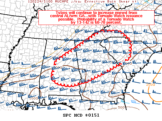
The greatest risk by severe weather should be east of Alabama by the time the watch is issued.
TURNING COOLER: Storms should be out of Alabama by mid-morning, and the rest of the day will be partly sunny, breezy, and cooler with temperatures falling into the mid 50s.
THE WEEKEND: Tomorrow will be sunny but cool with a high in the 55-60 degree range. Expect a partly sunny sky Sunday with a high around 60. Note that we will be well down in the 30s both mornings, with a light freeze possible in spots. Also there will be a chance of showers Sunday afternoon over the southern quarter of Alabama, but for now nothing is expected up this way.
NEXT WEEK: The latest global runs have looked pretty dry Monday, but we will bring in a chance of showers Tuesday, with thunderstorms possible Wednesday as a cold front approaches. We warm up again, with low to mid 70s by Tuesday and Wednesday as the mild winter of 2011-12 continues. The Wednesday thunderstorm event for now doesn’t look like a severe weather setup, and drier air (but not really cooler) returns by Thursday and Friday.
And, still no sign of any really long lasting or severely cold air moving into Alabama through mid-March. See the Weather Xtreme video for the graphics and details.
STORM ALERT 2012: Again a reminder our annual severe weather awareness tour rolls along. The next show will be in Cullman on Tuesday of next week, February 28, at 6:30. One of the featured stories we are doing this year is looking at the April 27, 2011 tornado outbreak through the eyes of a child, featuring letters written by kids from East Elementary in Cullman.
WEATHER BRAINS: Don’t forget you can listen to our weekly 90 minute netcast anytime on the web, or on iTunes. This is the show all about weather featuring many familiar voices, including our meteorologists here at ABC 33/40.
CONNECT: You can find me on all of the major social networks…
I have a weather program later today at McElwain Christian Academy… look for the next Weather Xtreme video here by 3:30 or so this afternoon. Enjoy the day!



