


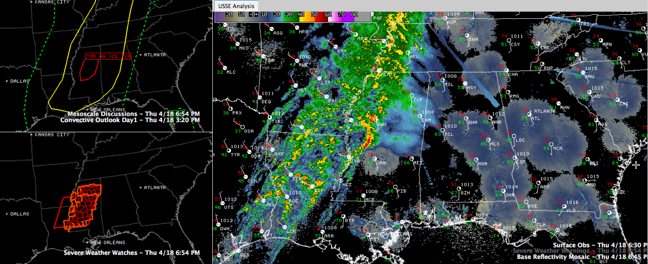
Strong thunderstorms are moving across Central Mississippi tonight, prompting several tornado warnings late this afternoon and evening.
One is passing south of Yazoo City now. This storm shows high potential for straight line wind damage and has shown the potential for embedded tornadic vortices as well.A brief tornado was reported crossing US-61 at 5:22 p.m. near Nitta Yuma in Sharkey County with this storm. The tornado warning that was on it for Yazoo County was just allowed to expire but a severe thunderstorm warning remains in effect. It is passing well north of the City of Jackson as it continues east northeast.
Another possible tornado was south of Greenwood MS earlier, but that more northern storm has weakened. It is operating in an area where instabilities are lower.
A tornado watch is in effect for Central Mississippi.
Instabilities feeding into the southern storm are on the order of 1,000-1,500 j/kg, which should keep them intense for the next few hours.
Hopefully, instabilities will continue to be low and even drop ahead of the storms over Mississippi and into Alabama as we head deeper into the evening and away from the heating of the day. The SPC just said that in a new Mesoscale Discussion.
MESOSCALE DISCUSSION 0526
NWS STORM PREDICTION CENTER NORMAN OK
0652 PM CDT THU APR 18 2013
AREAS AFFECTED…NRN/CNTRL MS
CONCERNING…TORNADO WATCH 126…128…
VALID 182352Z – 190115Z
THE SEVERE WEATHER THREAT FOR TORNADO WATCH 126…128…CONTINUES.
SUMMARY…DAMAGING WIND/TORNADO THREAT ALONG THE REMNANT PORTION OF
QLCS APPEARS TO HAVE PEAKED AND SHOULD BECOME INCREASINGLY
ISOLATED/MARGINAL THROUGH THE EVENING.
DISCUSSION…MID-LEVEL REFLECTIVITY CORES HAVE WEAKENED
SUBSTANTIALLY IN THE PAST HALF HOUR WHILE BASE REFLECTIVITY
STRUCTURES HAVE BECOME MORE ELONGATED WITHIN THE REMNANT QLCS. THESE
DIMINISHING TRENDS ARE PROBABLY A RESULT OF THE LINE CROSSING THE
INSTABILITY AXIS THAT HAD BEEN ALONG THE MS RIVER.
NEVERTHELESS…THE 00Z JAN RAOB SAMPLED A LARGE CURVING HODOGRAPH
WHICH STILL PROVIDES CONCERN FOR AT LEAST SOME SEVERE THREAT
PERSISTING…PERHAPS JUST SPATIALLY CONFINED TO THE FAR SRN PORTION
OF THE QLCS WHERE INFLOW OF WEAK BUOYANCY IS GREATEST.
Wind shear profiles are sufficient for severe weather across Mississippi into Alabama, however, so we will be tracking the storms as they approach Central Alabama.
The line of storms is pushing east at 25 mph. Extrapolating at this speed of motion, it will be approaching the western Alabama border between Sumter and Lamar Counties in 3-4 hours.



