


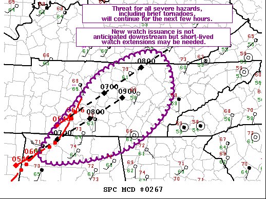
The severe weather threat for Tornado Watch 74, 75 continues.
SUMMARY…
The threat for all severe hazards, include brief tornadoes, will continue across middle TN and northern AL for the next few hours. Less favorable downstream environment is expected to preclude new watch issuance but short-lived, local watch extensions may needed.
DISCUSSION…
Radar imagery of the ongoing cluster of storms over the southern portion of middle TN has shown an increase in forward speed over the past half hour or so. Echo tops have also increased during this time. These observations suggest a continued threat for severe will likely exist downstream of these storms for at least the next hour or so. Primary threat with this cluster is strong wind gusts, although an brief embedded tornado and/or hail also remain possible. Storm motion of this cluster was estimated to be northeast at 60 kt, taking it to the edge of Tornado Watch 74 around 2:30 am.
This fast northeastward motion will take the cluster ahead of the ongoing moisture return into a thermodynamic environment characterized by strong MLCIN, which should lead to a diminishing of storm intensity. Isolated damaging wind gusts will still be possible and short-lived, local watch extensions may needed. However, the limited spatial and temporal severe threat will likely preclude new watch issuance downstream.
A few stronger cells have also been noted within the line over northwest AL. Estimated storm motion within these cells is northeastward at 50 kt, taking them to the central AL/TN border around 2:00 am. Recent UAH SWIRLL soundings from Courtland AL and Huntsville AL both show a warm layer around 700 mb, which is likely leading to reduced updraft strength. Even so, the strong vertical shear will likely compensate for this reduced instability, leading to a continued severe threat for the next few hours.



