


Another fairly prototypical summer day is in store for Alabama as high pressure dominates our weather. There is a little patchy fog in spots this morning, but it is not as widespread as yesterday, since Saturday’s rainfall was not as widespread as that of Friday.
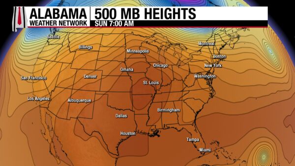
METEOROLOGICAL SETUP
A stout late-summer ridge arcs from the southern Plains into the Tennessee Valley, keeping most of Alabama hot and mainly rain-free while a weak trough and leftover upper level energy skirt the Appalachians; low-level flow is easterly/northeasterly with drier air aloft but plenty of near-surface humidity, and a northerly flow around the high pressure keeps better shower chances pinned closer to the Gulf Coast close to the seabreeze.
FOR YOUR SUNDAY
The state runs hot again today: highs 93–97 for North/Central Alabama (around 90 near the coast). Storms will be isolated to widely scattered, and favored east of I-65 and along the Florida Panhandle; any cell can briefly pulse strong with gusty outflow and frequent lightning thanks to high downdraft CAPE availability. Heat indices peak near 100–105, highest across the west. Heat advisories will be in effect again for Lamar, Fayette, and Pickens counties today.
SUNDAY NIGHT
Any storms fade quickly after sunset with a warm, muggy night in the low/mid 70s; patchy valley fog is possible toward daybreak.
EARLY WEEK HEAT
Ridging holds Monday and Tuesday with highs in the mid to upper 90s and peak heat indices again near 100–105; rain chances stay on the low side, though a touch more Appalachian-side convection could drift in Tuesday on the easterly flow.
MIDWEEK STORM CHANCES
Guidance continues to hint at a shortwave and weak front nosing toward the Mid-South midweek; if an MCS grows to our northwest Wednesday, it may dive into the Tennessee Valley late day or evening with a damaging wind risk—another round is possible Thursday as the boundary sags south. In any case, storms should increase with the presence of the boundary.
LATE WEEK TRENDS
The front and weakening trough settle closer Friday, boosting shower and storm coverage and trimming the heat—many spots fall back into the mid/upper 80s by Friday with lower heat stress.
WEEK TWO VOODOO
Signals favor a more seasonable regime: lingering ridge influence to our west with periodic troughing over the East keeps scattered, mainly afternoon storms in play and temps near to a bit below average late in week one trending back to near average into week two.
SEVERE WEATHER OUTLOOK
The SPC Day 2 Outlook highlights only marginal severe potential well to our north: isolated severe storms from the Upper Midwest into the northern High Plains, plus localized damaging winds/small hail across parts of New England; Alabama stays outside the risk area with only a low-end microburst threat in any isolated pulse storm Sunday afternoon.
TROPICAL WEATHER OUTLOOK
Hurricane Erin remains a powerful category 3 western Atlantic hurricane but is undergoing eyewall-replacement fluctuations; guidance shifts a bit west but still turns Erin north over the next few days, keeping the core well east of the U.S. mainland while the storm grows in size—expect increasing surf and rip current hazards along the western Atlantic next week and Bermuda should monitor for midweek impacts; no direct effects for Alabama’s weather of weather along the Gulf Coast.
BEACH FORECAST – BEAUTIFUL BEACHES OF ALABAMA & NORTHWEST FLORIDA
Low rip current risk today through Wednesday along Alabama beaches and the western Florida Panhandle beaches, with surf around 1 ft and Gulf water temps in the mid-80s; The eastern Panhandle beaches (Walton, Bay, Gulf, Franklin counties) carry a moderate rip current risk through at least Wednesday with surf near 1 ft and water near 85°. Expect mostly sunny mornings, a chance of scattered afternoon storms each day, and UV Index in the extreme category—reapply sunscreen often and heed local flags.
WEATHERBRAINS: AI MEETS WEATHER
Monday at 7:00 pm CDT on youtube.com/weatherbrains: Dr. Paris Perdikaris (University of Pennsylvania; former Principal Scientist at Microsoft Research who led Aurora, an AI foundation model for Earth system forecasting). Full archives at weatherbrains.com and on all major podcast platforms.
WEATHER HISTORY
On this date in 1969, Hurricane Camille was marching across the central Gulf, forcing warnings from Alabama to Louisiana after a forecast nudge west from the Florida Panhandle. The new SPLASH storm-surge model projected 20+ feet near and east of landfall. Recon later measured a record-low 901 mb and estimated 190 mph winds, reporting the most intense winds they’d ever encountered. Camille made landfall near Pass Christian, MS around 11 pm with winds over 200 mph and a storm tide near 27 feet, killing 143 along the coast with 27 missing. Another 113 died in catastrophic flash floods and landslides over the Appalachians as the remnants unloaded torrential rain. Over 5,500 were injured and damage topped $1 billion; Robert Simpson called Camille “the greatest storm of any kind ever to have affected the mainland of the United States.”



