


February 2020 already stands as the 4th wettest February in Birmingham history. We are just a smidge below pushing this month solidly into 3rd place. First and second place are unattainable, as they are both over 15 inches, but the month will likely finish in 3rd place. These are 30-day precipitation amounts across our state:
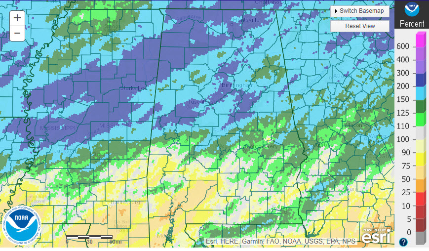
30 day precipitation totals as a percent of normal
MORE RAINFALL ON THE WAY: Not what you want to hear, I know, but it does not appear that flash flooding will be a problem over the next two weeks. But river and stream flooding will certainly be worsened. Let’s dig into the details.
FOR YOUR SUNDAY: A disturbance is passing through Alabama today, and it has just enough moisture to shake out a few sprinkles and showers. That precipitation will be mainly limited to the southern half of the state, and mainly occurring this morning. Skies are starting off cloudy, but a few breaks will start showing up as we go through the day. Temperatures will warm into the upper 50s to lower 60s this afternoon. Right around normal for this time of year. Lows tonight will drop into the 40s.
MONDAY: Another approaching ripple in the flow will pull a warm front northward tomorrow, triggering more rain by Monday night. There could be thunder at times late Monday night. It will be quite mild, with afternoon highs in the middle to upper 60s. Southern sections of Central Alabama will flirt with 70F. Lows Monday night will be in the 50s.
RAIN CONTINUES ON TUESDAY: Surface low pressure moving through the Great Lakes will push a cold front towards Alabama on Tuesday. Rain and thunderstorms will be a good bet. Rain will be generally less than one inch north of I-20 and between one and two inches south of I-20. The rain will end gradually Tuesday night, but a few showers will linger into Wednesday morning. But another disturbance will approach Wednesday night, triggering more precipitation starting during the pre-dawn hours on Thursday morning. There is some chance that atmospheric profiles will be cold enough for the precipitation to fall as snow across the Tennessee Valley. Snowfall amounts will be less than one-half inch and should be inconsequential. To the south, rain will fall through midday in areas north of I-20, gradually ending from the northwest. Highs will be limited to the 30s over North Alabama, with 40s over the central part of the state. Thursday night lows will drop below freezing.
FRIDAY INTO THE WEEKEND: High pressure builds into the eastern half of the country by Friday, setting the stage for dry conditions for the weekend. Showers will return by Sunday night, though. Weekend highs will be near normal.
VOODOO TERRITORY: Another storm system will affect Alabama around Tuesday, the 25th. This system has some potential to produce severe weather for Alabama. In any case, rain and thunderstorms will be likely.
GULF COAST WEATHER: Rain is likely along parts of the beautiful beaches of Alabama and Northwest Florida. Rain and storms will be possible through Thursday, with the highest chances Tuesday. Highs will warm into the 70s Monday, Tuesday, and Wednesday before falling back into the 50s the rest of the week. Water temperatures are running 62F.
Click here to see the Beach Forecast Center page.
WEATHERBRAINS: This week, the panel will entertain Dr. Cliff Mass. Check out the show at www.WeatherBrains.com. You can also subscribe on iTunes. You can watch the show live at live.bigbrainsmedia.com You will be able to see the show on the James Spann 24×7 weather channel on cable or directly over the air on the dot 2 feed.
ON THIS DATE IN 2001: A strong squall line produced several bow echoes across eastern Mississippi into central Alabama, producing widespread wind damage. Unseasonably warm air preceded the storm over the Southeast. The mercury rose to a record high of 80 degrees at Birmingham before the thunderstorm reached the city. The temperature dropped 16 degrees in 6 minutes at the airport and winds gusted to 100 mph at the ABC3340 WeatherNet site next to Legion Field. The windstorms produced the third-largest power outage in the history of the state of Alabama, with over 300,000 customers without power. One woman died in Mississippi and another woman died in the Birmingham area when a tree fell on her car. Follow my weather history tweets on Twitter. I am @wxhistorian at Twitter.com.



