


Daily Briefing
Sunday, November 30, 2025
SATURDAY RECAP
Saturday was a dry, cool day across Alabama with filtered sunshine and increasing clouds late. Highs reached the mid 50s across the northern counties and upper 50s to near 60 farther south. Humidity remained low early in the day before moisture began creeping back, setting the stage for today’s widespread rain.
Michelle Miklik, long-time Skywatcher, sent this photo of two elegant eagles from Lake Guntersville.

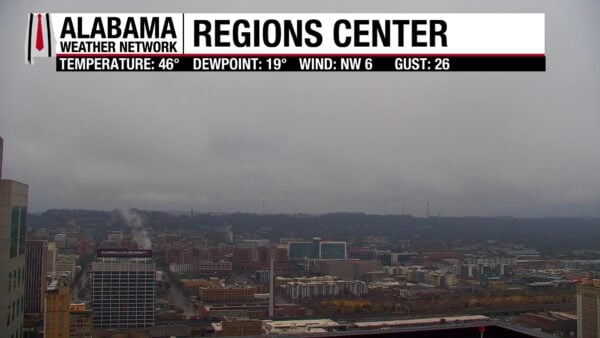
A chilly, raw Sunday morning is unfolding across Alabama as a weakening front brings widespread light to moderate rain statewide. Temperatures sit in the upper 30s to mid 40s in the north and low to mid 50s farther south, with thick clouds and a steady north breeze making it feel even cooler. Showers will continue through late morning before gradually tapering west to east.
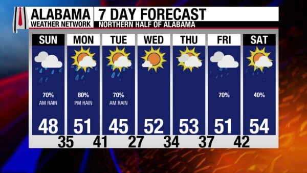
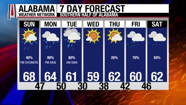
ALABAMA 7 DAY FORECAST
A weakening band of showers is moving through Alabama this morning as a cold front sweeps west to east, bringing a chilly, raw start to the day statewide. The wet pattern continues into early next week with another round of heavier rain on the way Monday into Tuesday.
STEADY RAIN TO START SUNDAY
Periods of rain move across the state through late morning, with the most persistent showers in central and north Alabama. Skies will be slow to brighten, but west Alabama may see some late-day breaks before sunset while eastern counties stay cloudy. Highs struggle through the 40s in the Tennessee Valley and hold in the lower to mid 50s elsewhere, making for a damp, cool day overall.
TURNING COLDER TONIGHT
Clouds gradually thin from west to east after sunset, but temperatures drop quickly behind the front. Overnight lows fall into the upper 20s in north Alabama, mid 30s in central counties, and lower 40s toward the Wiregrass and Gulf Coast. A light north breeze will push wind chills into the upper teens and 20s across much of the northern half of the state.
MONDAY: MOISTURE SURGES BACK
Clouds thicken again Monday as a developing Gulf low spreads moisture inland from south to north. Light rain arrives by afternoon across southwest and central Alabama, with coverage expanding Monday night. Highs range from the upper 40s north to the lower 60s south. While instability stays minimal, there could be a little thunder along the far southern tier late Monday night. No severe weather is expected.
TUESDAY THROUGH THURSDAY: WET, THEN CLEAR AND COLDER
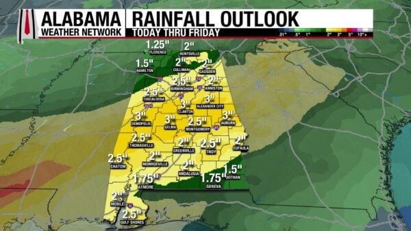
Widespread rain is likely Tuesday morning with locally heavy totals—generally 1 to 2 inches—especially from Montgomery to Mobile and into southeast Alabama. Rain exits Tuesday afternoon, followed by a shot of cold, dry air Tuesday night with lows in the 20s north and 30s south. Wednesday stays sunny and cold, and Thursday brings increasing clouds as the next system approaches but most areas remain dry through daylight hours.
FRIDAY AND SATURDAY: NEXT SYSTEM LOOMS
A broad western U.S. trough sends pieces of energy toward Alabama by the end of the week, gradually returning rain chances on Friday. Temperatures stay seasonable, with highs in the upper 40s to mid 50s north and low to mid 60s south. The timing of the next round of rain is still uncertain, but the trend favors increasing showers heading into next weekend.

THIS WEEK’S WEATHERBRAINS
This week’s episode of WeatherBrains will feature Dr. Owen Shieh. He is the Warning Coordination Meteorologist at the Weather Prediction Center. He has had an amazing career already in his relatively young life, serving in important positions in military meteorology and was named the Navy’s Oceanographer of the Year.

Gregg Dubin sent in this festive photo of snow beginning at Shipshewana IN yesterday!
HEAVY SNOW IMPACTING MIDWEST AND GREAT LAKES
A large winter storm is sweeping east through the Plains and into the Midwest and Great Lakes today, bringing widespread heavy snow from the Dakotas and Nebraska into Minnesota, Wisconsin, and northern Michigan. Snowfall rates may still reach 1–2 inches per hour this morning before gradually weakening later today. Travel remains hazardous across the region with gusty winds, reduced visibility, and snow-covered roads continuing into tonight.
GULF COAST SHOWERS WITH NON-SEVERE THUNDER
A cold front stretching from the Carolinas to the northwest Gulf is pushing steadily southeastward today, producing scattered showers from coastal Texas through Louisiana, Mississippi, Alabama, and into the Florida Panhandle. A few thunderstorms may develop close to the coast, but the Storm Prediction Center calls for no severe weather areas today. Rainfall may be locally heavy at times near the immediate Gulf Coast, but widespread flooding issues are not expected.
COLD PATTERN LOCKED IN ACROSS THE CENTRAL AND EASTERN U.S.
Much of the central and eastern United States will spend today well below average, with highs running 10–25 degrees under normal from the northern Plains to the Ohio Valley and down toward the Lower Mississippi Valley. Some locations in the northern Plains may remain in the single digits, while teens, 20s, and 30s stretch south and east through the Midwest and Tennessee Valley. Gusty winds behind the front will make for wind chills in the teens and 20s as far south as north Texas.
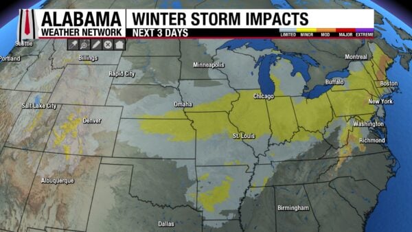
WINTRY MIX POSSIBLE IN THE NORTHEAST TONIGHT
As the same cold front moves offshore later today, lingering moisture encountering colder air may produce a bit of light snow or a wintry mix in interior New England tonight into early Monday. Accumulations look minor, but slick spots are possible on untreated roads. Farther south along the East Coast, showers taper from north to south as colder, drier air arrives.
ANOTHER SYSTEM EMERGING EARLY IN THE WEEK
A new upper trough developing over the Rockies will begin shifting east on Monday, bringing renewed chances for mountain snow in the central Rockies and light snow spreading into parts of the northern Plains by late Monday. Farther south and east, the cold, dry air remains in place through the start of the week before moisture begins returning mid-week ahead of the next storm system.
ST. LOUIS BREAKS A RECORD!
A record snowfall of 6.4 inches was set at St. Louis yesterday. This breaks the old record of 1.7 inches set in 1964. Several of our audience members sent in pictures of the STL snow! Thank you!
2025 ATLANTIC HURRICANE SEASON – PART 2
After a quiet first half and an unprecedented lull around the climatological peak, the back half of the 2025 season turned into a showcase of raw power: Humberto and Melissa joined Erin as Category 5 hurricanes, Imelda brushed Bermuda as a hurricane, and several late-season tropical storms added flooding and surf impacts across the Caribbean and Atlantic islands. By season’s end, the Atlantic had produced 13 named storms, 5 hurricanes, and 4 majors, with well over $10 billion in damage and more than a hundred lives lost—most of that tied to Hurricane Melissa.
HUMBERTO
Hurricane Humberto developed in the central tropical Atlantic and rapidly intensified into the season’s second Category 5 hurricane south of Bermuda. It curved north and passed northwest of Bermuda without making landfall, bringing squally weather and rough seas to the island and contributing moisture to a later European windstorm, but it caused minimal direct damage and no known fatalities.
IMELDA
Hurricane Imelda formed near Hispaniola, passed near the Bahamas, and then brushed Bermuda as a Category 2 hurricane with 100 mph winds before accelerating into the open Atlantic. Its precursor disturbance and outer bands produced torrential rains and squalls in Puerto Rico, the Dominican Republic, Haiti, and parts of the southeastern United States, leading to several flood deaths, beach erosion, structural damage along the Outer Banks, and more than $10 million in losses.
JERRY
Tropical Storm Jerry formed in the tropical Atlantic and tracked near the Lesser Antilles, where it dumped over 9 inches of rain in spots. The storm triggered flash flooding, minor landslides, road and business inundation, isolated power outages, and at least one fatality after a vehicle was swept away in floodwaters, along with maritime rescues in rough seas around Guadeloupe.
KAREN
Subtropical Storm Karen was a compact, short-lived system northwest of the Azores that transitioned from a non-tropical low. It produced some locally gusty winds and showers over open water before quickly losing its convection over cooler seas, with no reported damage or deaths.
LORENZO
Tropical Storm Lorenzo formed over the eastern tropical Atlantic and struggled against shear and dry air, peaking as a moderate tropical storm before degenerating into a remnant low. Lorenzo stayed far from land and is mainly a statistical footnote for the season—no known impacts, no damage, and no fatalities.
MELISSA
Hurricane Melissa was the capstone of the season and its most infamous storm, undergoing explosive rapid intensification over the central Caribbean to become a 185 mph Category 5 hurricane with a central pressure of 892 mb—one of the most intense Atlantic hurricanes on record. Melissa made landfall in Jamaica at peak intensity, bringing catastrophic wind damage, storm surge, and flooding, then crossed eastern Cuba and later affected the Bahamas, Hispaniola, Bermuda, and parts of the U.S. East Coast with heavy rain and dangerous surf. The storm caused on the order of $10 billion in damage and well over 100 deaths across the Caribbean basin, making it by far the deadliest and costliest storm of the 2025 season.
In all, the late-season surge of powerful hurricanes—topped by Melissa’s catastrophic run through the Caribbean—transformed a slow, uneven start into a season defined by intensity rather than frequency, leaving behind major damage, high ACE, and one of the most memorable finishes in recent Atlantic history.
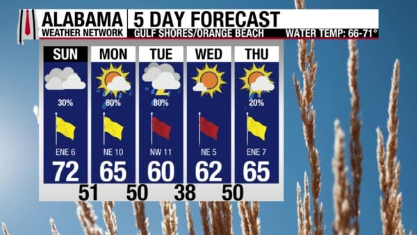
GULF BEACHES: MILD TODAY, HIGHER SURF AND RIP RISKS AHEAD
If you’re headed to the Gulf beaches today, expect a moderate rip current risk for most Alabama and Florida Panhandle beaches, with surf running around 1–2 feet and water temperatures in the mid 60s. Skies will be partly to mostly sunny with a chance of showers at times, and highs will range from the upper 60s to lower 70s depending on location. Winds will be generally from the east or northeast around 10–15 mph, increasing a bit tonight. Surf builds on Monday to 2–3 feet with continued moderate rip current danger, and a high rip current risk returns Monday night into Tuesday as a strong front moves through, bringing rougher surf (3–5 feet) and widespread showers. Cooler, sunnier weather returns by midweek with surf gradually lowering and rip current risks improving.
TODAY IN WEATHER HISTORY
November 30, 1784 – FIRST WEATHER RESEARCH FLIGHT
On November 30, 1784, Dr. John Jeffries and balloonist Jean-Pierre Blanchard completed the first known meteorological research flight. They ascended in a balloon from near Grosvenor Square in London at 2:28 p.m. and landed 81 minutes later in Stone, near Dartford in Kent. During the flight, they rose above 9,000 feet, noted freezing temperatures around 6,000 feet, and even enjoyed what is considered the first in-flight meal—cold chicken and wine—at about 4,000 feet. Most importantly, they collected measurements of temperature and air pressure at various altitudes, marking one of the earliest scientific attempts to study the upper atmosphere. Their pioneering ascent helped set the stage for the use of balloons in atmospheric research, a key tool that remains central to modern meteorology.

Spann Skywatcher Sandra Kirkwood captured this beautiful sunrise from her New Market location in Madison County in North Alabama, Saturday morning! Thanks to all of our Skywatchers for their contributions!



