


The unsettled pattern that has been a big part of the weather across Alabama for much of the past two months will shut down for the better part of the week ahead, giving us hot and dry summertime weather with very little if any rain chances. Lower dewpoints will help temper the impact of the heat just a bit. Let’s start with the big picture…
THE UPPER PATTERN OVER NORTH AMERICA has been dominated by a huge heat ridge out west and lower than normal pressures over the eastern part of the country. It appears that high pressure will expand and build over all of the lower 48 in the next couple of days, putting the kibosh on those daily afternoon and evening summertime thunderstorms that we know and love.
FOR YOUR SUNDAY: Slightly drier air has filtered into North and Central Alabama behind a cold front that is lying over South Alabama this morning. The lower dewpoints are allowing for lows in the 60s over the northern half of the area this morning. Highs today will be in the upper 80s North, with lower 90s across Central Alabama.
THE WEEK AHEAD: We will enjoy at least two more mornings of those lows in the 60s for lucky locations over the northern half of the state. By Wednesday morning and beyond, lows will be in the 70s once again. Afternoon readings will be in the lower 90s all week, ranging between 90-94F. Those widely scattered afternoon and evening showers and storms will disappear through Thursday, but enough moisture will remain Friday and Saturday for them to make a reappearance. BY Sunday, they will be a little more numerous.
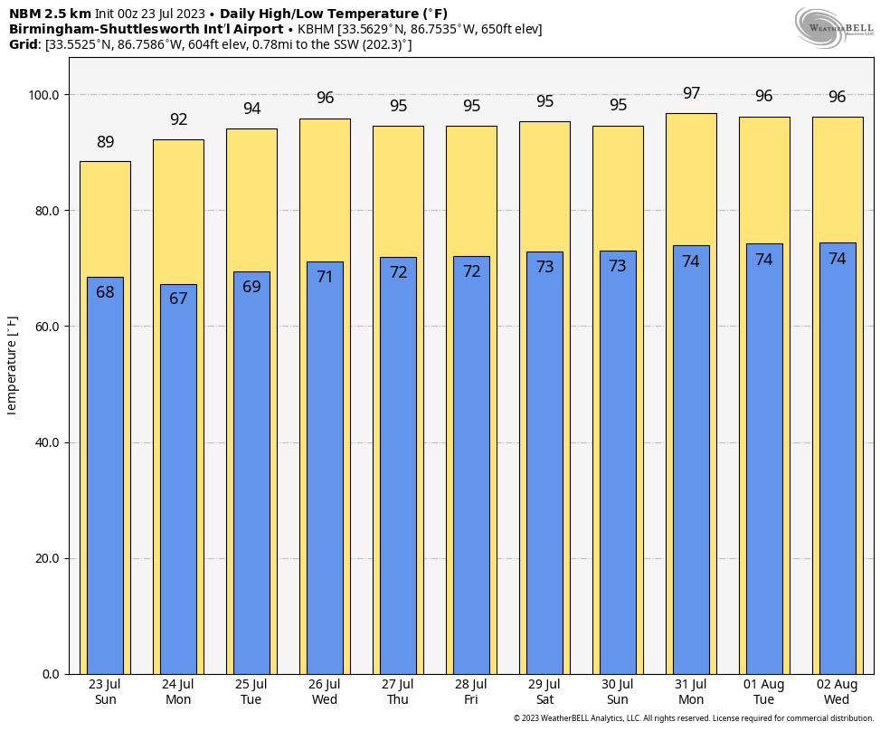
VOODOO WEEK TWO: Fairly typical summertime weather is on tap for the extended period with just isolated afternoon and evening storms Monday through Friday. Rain chances look a little higher the weekend of the 5th and 6th. Then it is back to school for many area school systems.
BEACHCAST: Our early morning showers and storms sunk all the way to our beautiful beaches of Alabama and Northwest Florida yesterday, making for a stormy afternoon. The convection zone will still be down south today, but rain chances should ease back a bit tomorrow and stay low through much of the work week. Storms will only be isolated during Monday – Friday period. Moisture levels should ramp back up by the weekend, and storms will become a little more common. Highs today will be limited to the 80s but the rest of the week we will see highs in the lower 90s and lows in the middle 70s all the rest of the week. Water temperatures are starting to peak out now. They are in the middle 80s. The rip current risk will be low through midweek, but check and obey those beach flags. Double red means stay out of the water. Single red means only the strongest swimmers should be in the surf. Go back and watch our great weather brains show from last Monday night after rip currents. It is every eye opening.
Click here to see the Beach Forecast Center page.
IN THE TROPICS: Don is hanging in there like a rusty fishhook on this Sunday morning. It became a hurricane late Saturday afternoon. It has had fun describing a huge loop in the northern Atlantic, strengthening as it moved south, and weakening as it moved north. It is now getting ready to recurve into the westerlies and will be a mere statistic by Monday. Top winds are between 55-60 mph this morning, and gradual weakening will occur today as it moves over cooler water. It should become post-tropical by tonight.
95L is a tropical wave in the Main Development Region of the Atlantic. It will be near the Lesser Antilles Tuesday. It has become a little less organized over the past 24 hours, but it still has some potential for development. The global models like its chances to reach tropical storm strength before it reaches the islands, but weakens it over the Caribbean and doesn’t have it amounting to anything in the long run. If it does reach tropical storm strength, it will be Emily.
Elsewhere, there are a couple of promising tropical waves over Africa and in the far eastern Atlantic. We will have to watch them closely as we are moving into the busiest part of the season.
NATIONALLY: The heat is still the story over the Southwest. Phoenix will be within one degrees of their daily record today with a high of 114F and Tucson should break the daily record by 1 degree with a high of 109F.
DANCING WITH THE STATS: San Antonio, TX established a new record for the date on Saturday with a high of 104F. The old record was 103F.
ADVERTISE WITH US: Deliver your message to a highly engaged audience by advertising on the AlabamaWX.com website. We have a lot of big plans for this year. Don’t miss out! We can customize a creative, flexible, and affordable package that will suit your organization’s needs. Contact me, Bill Murray, at (205) 687-0782 and let’s talk.
WEATHERBRAINS: This week, the panel will entertain Dr. Kevin Perry, a Professor in the Atmospheric Sciences Department at the University of Utah. We will be talking about the challenges facing America’s Dead Sea, the very living Great Salt Lake. Check out the show at www.WeatherBrains.com. You can also subscribe on iTunes. You can watch the show live on our new YouTube channel for the show.You will be able to see the show on the James Spann 24×7 weather channel on cable or directly over the air on the dot 2 feed.
ON THIS DATE IN 2011: O’Hare Airport in Chicago set a new 24 hour rainfall record. And they had done it by 4 a.m.! 6.78 inches of rain fell in less than 4 hours as heavy thunderstorms pounded western sections of the Chicago Metro area. The total for the day was 6.92 inches, surpassing the 6.64 inches recorded on September 13, 2008 and the 6.49 inches that fell on August 14, 1987. Many area expressways and roads, including routes to the airport were closed. Follow my weather history tweets on Twitter. I am @wxhistorian at Twitter.com.



