


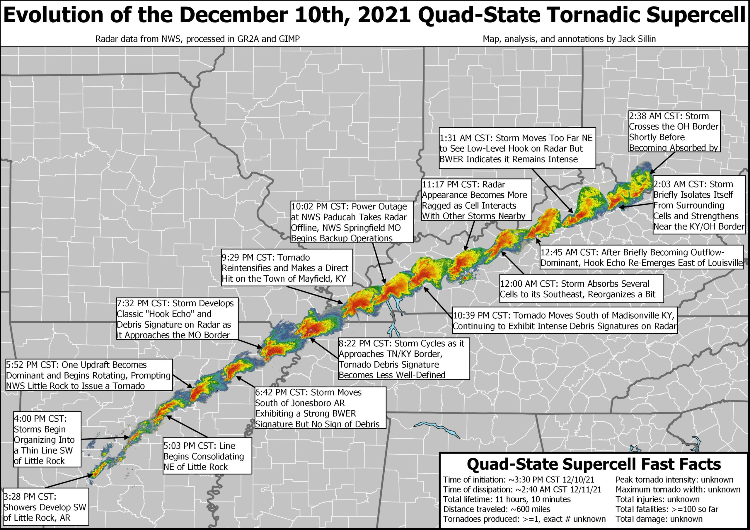
It is with deep sadness that we continue to follow the rescue and recovery out Arkansas, Missouri, Tennessee, and especially hard hit Kentucky, where a historic tornado outbreak struck Friday evening into early Saturday. A long-lived supercell streaked 240 miles from northeastern Arkansas all the way to North Central Kentucky. National Weather Service survey teams from multiple offices are feverishly investigating the tracks across their areas of responsibility. Will they find a new record track length, breaking the long-time record held by the Tri-State Tornado of 1925 (219 miles)? Or was it a family of tornadoes from the same storm? It doesn’t matter. The suffering and heartbreak is not something Alabamians are unfamiliar with, and our thoughts and prayers go out to all our friends and neighbors in the affected areas.
ALABAMA CAUGHT A BREAK: Unlike areas to the northwest and north, Alabama escaped significant severe weather from this event as the storms arrived at the diurnal minimum of temperatures even as the best dynamic lifted out to the northeast overnight. There were a few warnings, and a few reports of trees down across North Alabama early this morning. And looking out into the future, we don’t see any more threatening system through the next 7 days.
FOR YOUR SUNDAY: We’re starting off in the 30s over the northern half of the state, with 40s over South Alabama. Skies have cleared for the most part, and temperatures will struggle to get out of the 40s North today, with 50s across the rest of Alabama. Gusty winds early should calm down fairly quickly. With clear, calm conditions, overnight lows tonight will drop into the 30s again over the northern half of the state with 40s down south.
ABOVE NORMAL TEMPS RETURN: High pressure currently centered from the western Atlantic into the Deep South will edge just enough to the east to allow the heat and moisture pump to start up again. Folks in Southeast Alabama will already feel it tonight with lows dropping only into the upper 40s.
NEW WORK WEEK: All the action will be out west as the new work week begins. High pressure will be large and in charge for us, with sunny conditions continuing. Temperatures will warm into the middle and upper 60s as the warm-up gets started in earnest. All the while though, moisture will be surging into the ArkLaTex. Monday night lows will be in the 40s. Tuesday, highs will be pushing 70F in spots. Skies will be partly cloudy with a mix of sun, despite moisture levels starting to surge for us as well. Some amazing temperature anomalies will be affecting the Central Plains, with readings over Oklahoma running 35-40 degrees above normal!
MID TO LATE WEEK: The ridging over the eastern United States actually intensifies as the trough to our west deepens. Moisture will be pushing 200% of normal, and we will see some low clouds, and probably partly sunny skies at best on Wednesday. We should be dry though. Highs will again push 70F. On Thursday, a piece of the western trough will rotate up to the Great Lakes, powering a cold front that will approach us from the northwest. As a result, clouds will be increasing over Alabama. Look for highs in the lower 70s. By Friday, the high will hang on stubbornly to its tenuous hold along the Southeast coast and the front will lift back north as a warm front without passing I-20. There could be a shower or two Thursday and Friday. 70s will continue as above-normal temps remain.
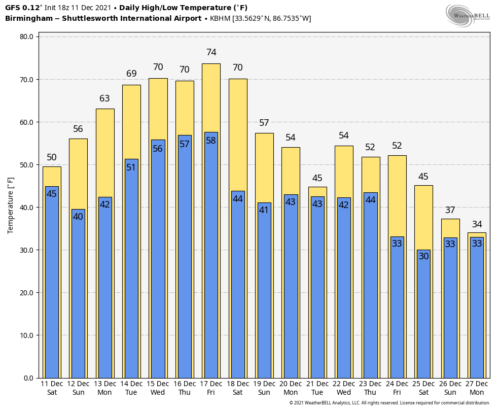
WEEKEND OUTLOOK: By Saturday, a split flow will develop in the upper pattern across North America. A trough will be moving through the Great Lakes, with the southern branch cutting off to an upper low along the California Coast. A cold front, empowered by the Great Lakes trough, will approach Alabama from the northwest. We will be mostly cloudy with a chance of rain. Expect less than a quarter of an inch of rain. Another disturbance rotates into the southern Plains on Sunday, surging moisture northward into Alabama behind the retreating front again. Weekend highs will be in the 60s. Lows in the 50s.
CHRISTMAS WEEK: Rain will be widespread on the Monday and Tuesday of the holiday week. A general soaking may be in the offing, with up to 2 inches of rain possible. It will be sharply cooler with highs in the 50s and lows in the 40s. Christmas Eve will be wet as well, with sharply colder conditions for Christmas Day. By the 26th, highs will do a flip flop, running 15 degrees below normal, which will result in some 30s across North Alabama.
BEACHCAST: Another gorgeous week along the beautiful beaches of Alabama and Northwest Florida. High pressure will remain in control of the weather there much as it will here until next weekend. The first rain chances will come from a weakening front next Saturday night and Sunday. Highs today will be in the 60s, but 70s will prevail the rest of the week. Lows all week will be right around 60F.
Click here to see the Beach Forecast Center page.
NATIONALLY: I don’t think anyone in the West is complaining about the rain and mountain snows that will be affecting them over the next couple of days. The activity is already underway across Washington, Oregon, and northern California. It will spread southward into the rest of California as the surface lows move southeast. Even Nevada will get in on the action. Las Vegas could see a rain/snow mix by Tuesday night.
DANCING WITH THE STATS: Record highs yesterday across the northeastern United States as well as the Southeast ahead of the powerful cold front that led to all of the severe weather. The 65F at New York City’s Central Park was a new record for the date, breaking the old record of 64F. Newark also bested their previous record for the date with 66F. Closer to home, Montgomery broke their record for the date with a high of 82F.
LEONARD. IS THAT YOU? Comet Leonard (C/2021 A1) is approaching Earth for a close encounter on Dec. 12th. So far this week, the comet has nearly tripled in brightness, making it an easy target for small telescopes and digital cameras. Six days after its close approach to Earth, Comet Leonard will have an even closer encounter with Venus. That flyby will be visible in evening skies next week.
ADVERTISE WITH US: Deliver your message to a highly engaged audience by advertising on the AlabamaWX.com website. The site enjoyed over 25 MILLION page views in the past 12 months. Don’t miss out! We can customize a creative, flexible, and affordable package that will suit your organization’s needs. Contact me, Bill Murray, at (205) 687-0782, and let’s talk.
WEATHERBRAINS: This week, the panel will talk about the Mid South tornado outbreak for sure. Dr. Kandis Boyd, a pioneer in women in meteorology, will be the main Guest WeatherBrain. Check out the show at www.WeatherBrains.com. You can also subscribe on iTunes. You can watch the show live at live.bigbrainsmedia.com or at You will be able to see the show on the James Spann 24×7 weather channel on cable or directly over the air on the dot 2 feed.
ON THIS DATE IN 1967: The snow began just after midnight. By mid-morning, it was falling heavily. By sundown, 26.8 inches of snow was on the ground at Flagstaff, Arizona, located at elevation 7,000 feet on the Arizona Plateau. Another big snow would begin to fall on the 14th, and in just over 24 hours, it dumped another 15.5 inches on the beleaguered city. More snow began to fall around noon on the 16th, with another 9.5 inches adding to the snow totals. The biggest snowfall of the extended snowstorm began on the 18th and did not let up for nearly two days, as a whopping 29.9 inches fell. When all was said and done, a grand total of 83 inches was on the ground, shattering the old record of 68 inches. The unrelenting snows hit the area hard. Food had to be airlifted in. The Reservations of the Native Americans were especially hard hit. Follow my weather history tweets on Twitter. I am @wxhistorian at Twitter.com.



