


An all new edition of the ABC 33/40 Weather Xtreme video is available in the player on the right sidebar of the blog. You can subscribe to the Weather Xtreme video on iTunes by clicking here.
TOO COLD FOR NOVEMBER: Here are some early morning temperatures, right before daybreak…
Black Creek (just northeast of Gadsden in Etowah County) 18
Decatur 24
Haleyville 25
Birmingham 25
Fayette 27
Auburn 27
Jemison 28
Coker 29
Greenville 31
Even a big chill down in Mobile, where they report 33 degrees at 6:00. Birmingham’s 25 is three degrees away from the record low of 22 degrees, set in 1911.
THE DAY AHEAD: We will enjoy a day of maximum available sunshine, but the weather stays cold with a high in the upper 40s. At least the wind won’t be as harsh today with a light pressure gradient.
ANOTHER FREEZE: We head back down into the mid 20s early tomorrow morning with a clear sky and light wind.
But, thankfully, these early season cold snaps don’t last too long. Tomorrow will be a sunny day with a high back in the 50s. Then, on Friday we reach the 60s with a partly sunny sky.
WEEKEND FORECAST: We will still hang on to a slight risk of a shower Saturday, but I believe most of the day will be dry across Alabama with a mix of sun and clouds. We continue to warm up nicely, and most places will reach 70 degrees Saturday afternoon.
The chance of rain will increase Sunday as a cold front approaches Alabama. We do note that the Storm Prediction Center has a severe weather outlook in place Sunday for much of Arkansas over into Northwest Mississippi and West Tennessee…
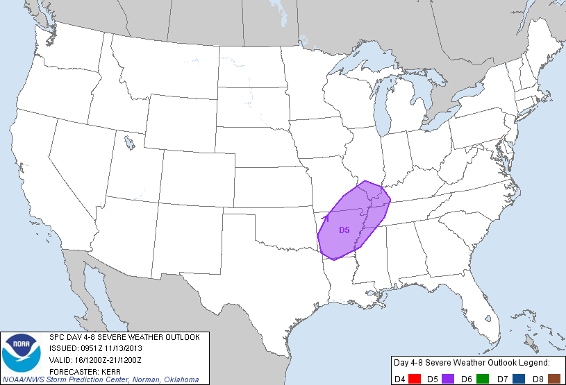
The main band of showers and storms ahead of the cold front should move into Alabama Sunday night, and with the better dynamics passing north of the state with very marginal instability values, for now severe weather doesn’t look like a big issue here. See the Weather Xtreme video for the maps, graphics, and details.
While showers are a good possibility Sunday, the main window for stronger storms ahead of the cold front will come from about 9:00 p.m. Sunday through 9:00 a.m. Monday.
NEXT WEEK: Colder and drier air moves back into Alabama Monday night; looks like we will have another early season freeze early Wednesday morning.
NEED YOUR WEATHER RADIO PROGRAMMED? We will be in Calhoun County at Downey Drug on U.S. 431 in Alexandria today from 3:30 until 6:30 p.m…. come see us. I will be there doing the weather live on ABC 33/40 at 4, 5, and 6:00.
WEATHER BRAINS: Don’t forget you can listen to our weekly 90 minute netcast anytime on the web, or on iTunes. This is the show all about weather featuring many familiar voices, including our meteorologists here at ABC 33/40.
CONNECT: You can find me on all of the major social networks…
Facebook
Twitter
Google Plus
Instagram
I have a weather program this morning at Striplin Elementary in Gadsden… look for the next Weather Xtreme video here by 4:00 this afternoon. Enjoy the day…



