


From Colorado State University
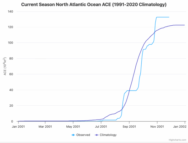
This is Part Two of our look back at the 2025 Atlantic hurricane season, a year that began quietly but evolved into one of the most intense stretches of late-season activity in modern records. After a sluggish start with weak early storms and an unprecedented midseason lull, the basin suddenly roared to life in late summer and fall, producing multiple Category 5 hurricanes and the catastrophic landfall of Hurricane Melissa in Jamaica. Today we pick up the story where the season turned sharply, with Gabrielle’s formation in mid-September and the explosive sequence of storms that followed. The accumulated cyclone energy (ACE) came in bursts, tied to the three category five hurricanes.
HUMBERTO
Hurricane Humberto developed in the central tropical Atlantic and rapidly intensified into the season’s second Category 5 hurricane south of Bermuda. It curved north and passed northwest of Bermuda without making landfall, bringing squally weather and rough seas to the island and contributing moisture to a later European windstorm, but it caused minimal direct damage and no known fatalities.
IMELDA
Hurricane Imelda formed near Hispaniola, passed near the Bahamas, and then brushed Bermuda as a Category 2 hurricane with 100 mph winds before accelerating into the open Atlantic. Its precursor disturbance and outer bands produced torrential rains and squalls in Puerto Rico, the Dominican Republic, Haiti, and parts of the southeastern United States, leading to several flood deaths, beach erosion, structural damage along the Outer Banks, and more than $10 million in losses.
JERRY
Tropical Storm Jerry formed in the tropical Atlantic and tracked near the Lesser Antilles, where it dumped over 9 inches of rain in spots. The storm triggered flash flooding, minor landslides, road and business inundation, isolated power outages, and at least one fatality after a vehicle was swept away in floodwaters, along with maritime rescues in rough seas around Guadeloupe.
KAREN
Subtropical Storm Karen was a compact, short-lived system northwest of the Azores that transitioned from a non-tropical low. It produced some locally gusty winds and showers over open water before quickly losing its convection over cooler seas, with no reported damage or deaths.
LORENZO
Tropical Storm Lorenzo formed over the eastern tropical Atlantic and struggled against shear and dry air, peaking as a moderate tropical storm before degenerating into a remnant low. Lorenzo stayed far from land and is mainly a statistical footnote for the season—no known impacts, no damage, and no fatalities.
MELISSA
Hurricane Melissa was the capstone of the season and its most infamous storm, undergoing explosive rapid intensification over the central Caribbean to become a 185 mph Category 5 hurricane with a central pressure of 892 mb—one of the most intense Atlantic hurricanes on record. Melissa made landfall in Jamaica at peak intensity, bringing catastrophic wind damage, storm surge, and flooding, then crossed eastern Cuba and later affected the Bahamas, Hispaniola, Bermuda, and parts of the U.S. East Coast with heavy rain and dangerous surf. The storm caused on the order of $10 billion in damage and well over 100 deaths across the Caribbean basin, making it by far the deadliest and costliest storm of the 2025 season.
In all, the late-season surge of powerful hurricanes—topped by Melissa’s catastrophic run through the Caribbean—transformed a slow, uneven start into a season defined by intensity rather than frequency, leaving behind major damage, high ACE, and one of the most memorable finishes in recent Atlantic history.



