


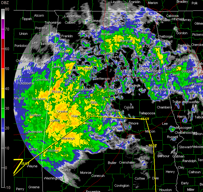
BMX radar at 217 p.m. with SPC Slight Risk shown in yellow
A large area of moderate to occasionally heavy rain covers much of West Alabama now from Pickens down to Marengo Counties. Showers are fairly numerous across the rest of the state at this hour.
In Mississippi heavy rain covers much of the state east of I-55 and south of US-82.
There is a severe thunderstorm warning for the Laurel area. A tornado warning is in effect for St. Bernard Parish in southeastern Louisiana.
A tornado watch remains in effect until 2 p.m. for southern Mississippi and southwestern Alabama. It will be extended into northwestern Florida and southern Alabama before its expiration.
The SPC’s latest Day One Convective Outlook current covers areas south of a line from Butler to Marion to Wetumpka to Tuskegee to Ozark. There could be a few tornadoes and damaging wind reports in this area, with the best chance near the Gulf Coast. Can’t rule out a severe thunderstorm with damaging winds up to about a line from Livingston to Vance to Vincent to south of Oxford, but the chance is small.
The thunderstorm activity is having a hard time getting its act together over Central Alabama due to the lingering affects of the cool air form the easterly wedge. Instability and shear is best closest to the coast.
For folks north of the severe weather potential area, the moderate rain will overspread the area and increase in intensity through the afternoon hours. There will eventually be some thunder mixed in. Once the main area arrives , it could rain for 4-5 hours. Rainfall amounts will be on the generous side, between 1.5-2.5 inches with some locally higher amounts.



