


It’s that time of year…late October, shorter days, lower sun angle, arctic getting cold. Usually, some time in late October, the cold air builds up enough that a piece of it will break away from the Arctic and head south into the US. That will happen this week.
With the ground being warm and releasing lots of heat, etc., it is hard to predict just how cold it will get. But, this air will be coming from Canada, and it will be a lot colder than it is today! As a matter of fact, in parts of NE Alabama, it could be nearly 50 degrees colder by Friday morning than it is now (it’s 81 in Fort Payne).
The European model is not as aggressive with the cold air, and Canadian model is a little too aggressive, and with the GFS in the middle, it may be the best guess, or somewhere between it and the Euro. Here are forecast temperatures over the next 5 days from the GFS (every 3 hours):
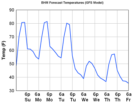
The cold front will move in on Tuesday, dropping temperatures from near 80 at mid-day, to the 40s by late evening. Highs may stay in the 50s on Wednesday and struggle to reach 60 on Thursday too, and with winds 10-20 mph, wind chills at times will be down near 30! That’s a big time change.
The coldest morning will be Friday. It’s too early to predict who will get frost, due to uncertainty with temperature and wind.
Needless to say, the big change to fall is coming this week, and most people’s home heating system will probably need to kick on by Wednesday night with the cool daytime temperatures and clouds, and very chilly lows between 35 and 45.



