


Lots of songs come to mind this morning as we sit around waiting for this event to unfold. The Waiting is the Hardest Part by Tom Petty is one. But probably more appropriately is a takeoff on hit The Thrill Is Gone by B.B. King. This morning, the CIN, or convective inhibition, or cap is gone now over Central Alabama. It has been eroded by increasing surface heating over West Central Alabama. Sunshine is increasing in most areas.
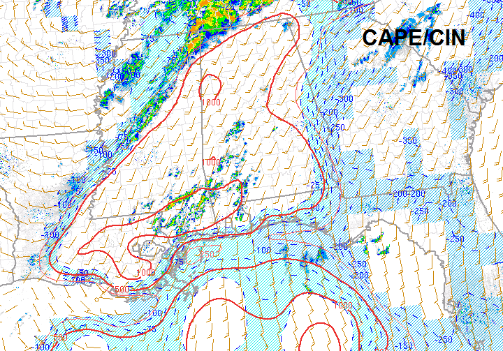
The CIN is the light blue shading. The red lines indicate levels of surface based CAPE, or instability.
This has allowed the Level of Free Convection to fall to levels that support tornado development now.
Instability levels are climbing with the heating, now in the 500-1000 j/kg2 range over all of Alabama and climbing. There is a bullseye of 1000+ h/kg2 CAPE over Lamar County.
Low level lapse rates are now primed over areas west of I-59 with a max near Columbus MS. Mid level lapse rates are moderately unstable. This means that air near the surface will be able to rise very rapidly allowing for thunderstorms to form and intensify quickly
Bulk shear is 45-60 knots across all of Central and North Alabama. This will allow any storms to quickly become organized.
Low level shear has dropped a bit with surface-1 km helicities dropping to around 300 m over the northwestern two thirds of the state. It is still maximized near the Shoals, which is close to the surface low. Helicities over 300 will still support strong rotation and tornadoes. Severe thunderstorm warnings have been issued for Franklin, Colbert and Lauderdale Counties of Northwest Alabama.
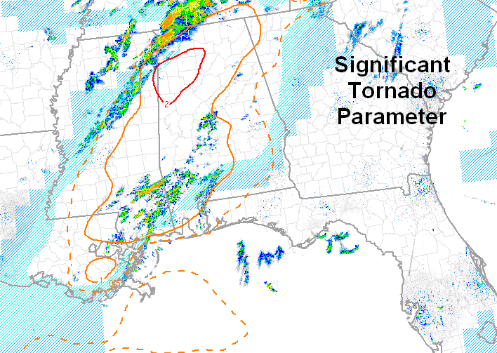
The Significant Tornado parameter is above 2 over Pickens, Lamar, Fayette, Marion, Walker and Winston Counties. The STP is one or greater over the northwestern two thirds of the state. STPs over 1 are associated with significant tornadoes. Less than 1, you generally don’t get tornadoes. This doesn’t mean we will have significant tornadoes, but it is a possibility.

The storms over Clay County MS that are moving toward Columbus will move into this area of maximum instability over Lamar, Marion, northwestern Walker and Winston Counties before noon. These storms will have to be watched carefully for the potential to become rapidly severe. Damaging winds and tornadoes will be possible.
All of these parameters are baed on this morning’s balloon launch and model data after that. The NWS Birmingham will launch another balloon at 11:30 a.m. to see what is really happening in the atmosphere. That will be very revealing.
A tornado watch remains in effect until 1 p.m. for much of Northwest and North Alabama. Central Alabama counties include Fayette, Lamar, Marion, Walker and Winston. North Alabama counties include Colbert, Cullman, DeKalb, Franklin, Jackson, Lauderdale, Lawrence, Limestone, Madison, Marshall and Morgan. A new watch will likely be required in areas to the southeast of this one as conditions become more unstable.
Stay alert today and be prepared.



