


This discussion sums it up for now:
…the line of storms is weakening as it encounters weakening instability in eastern Mississippi.
…but slightly higher dewpoints are creeping up into West Central Alabama. Tuscaloosa is at 64F now with a temperature of 79F, so warm air is still in place. Temperatures won’t cool substantially overnight thanks to the winds remaining up.
…wind shear profiles are still supportive of severe thunderstorms over Northwest Alabama and northeastern Mississippi though, so there is still a threat of isolated damaging winds and possibly even as tornado until the line weakens later tonight.
…probably won’t see a new watch later tonight unless things change.
The severe thunderstorm warning that was on the storm approaching Starkville was just canceled by the NWS Jackson. No reports of any damage in the past hour. There is still lightning, heavy rain and strong, gusty winds will the storm. It will reach southern Lamar and northern Pickens County by 10 p.m.
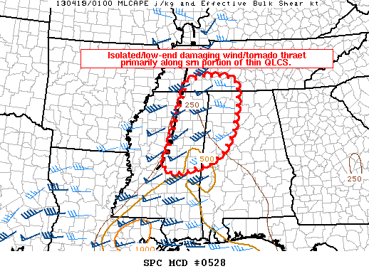
MESOSCALE DISCUSSION 0528
NWS STORM PREDICTION CENTER NORMAN OK
0846 PM CDT THU APR 18 2013
AREAS AFFECTED…NERN MS…NWRN AL…FAR SRN TN
CONCERNING…TORNADO WATCH 126…128…
VALID 190146Z – 190245Z
THE SEVERE WEATHER THREAT FOR TORNADO WATCH 126…128…CONTINUES.
SUMMARY…ISOLATED/LOW-END DAMAGING WIND AND TORNADO THREATS MAY
PERSIST ALONG PRIMARILY THE SRN PORTION OF A RELATIVELY THIN QLCS.
THE THREAT APPEARS TO BE TOO MARGINAL TO WARRANT AN ADDITIONAL
WW…BUT OBSERVATIONAL TRENDS WILL CONTINUE TO BE MONITORED.
DISCUSSION…HIGHER REFLECTIVITY CORES HAVE CONTINUED TO
ELONGATE/THIN IN THE PAST COUPLE OF HOURS…INDICATIVE OF
DIMINISHING INSTABILITY /ESPECIALLY WITH NRN EXTENT/. MEAGER
BUOYANCY/DESTABILIZATION IS STILL OCCURRING AHEAD OF THE LINE AS
SURFACE DEW POINTS HAVE SLOWLY RISEN INTO THE MIDDLE 60S ACROSS
E-CNTRL MS/W-CNTRL AL. LOW-LEVEL WIND PROFILES ARE VERY STRONG WITH
A LARGE CYCLONIC HODOGRAPH SAMPLED IN THE COLUMBUS AFB MS VWP DATA.
THUS…A LARGELY WANING BUT LOW-END DAMAGING WIND/TORNADO RISK COULD
PERSIST FOR A FEW MORE HOURS AS THE LINE SHIFTS EWD.



