



Dangerous storm in northeastern Tuscaloosa County near Windham Springs shows strong indications of rotation. It will take that familiar path up through Parrish and near Cordova or Jasper, eventually toward Sipsey and Sumiton.
Folks in these areas need to be in their tornao safe places now.
If you know folks in these areas that may not have access to the warning, please contact them!
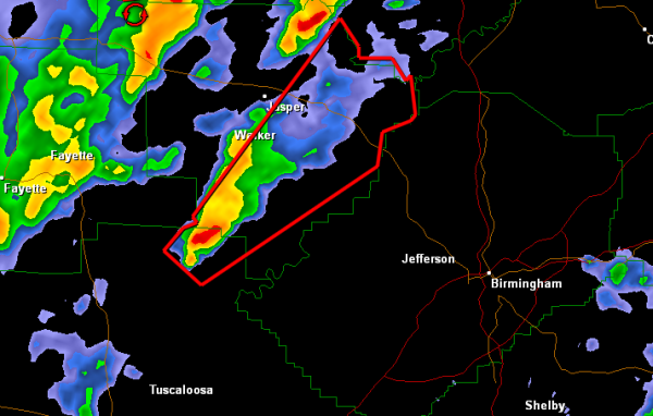
THE NATIONAL WEATHER SERVICE IN BIRMINGHAM HAS ISSUED A
* TORNADO WARNING FOR…
NORTH CENTRAL TUSCALOOSA COUNTY IN WEST CENTRAL ALABAMA…
EASTERN WALKER COUNTY IN ALABAMA…
* UNTIL 630 AM CST
* AT 548 AM CST…THE NATIONAL WEATHER SERVICE INDICATED A SEVERE
THUNDERSTORM CAPABLE OF PRODUCING A TORNADO. THIS DANGEROUS STORM
WAS LOCATED 8 MILES SOUTHEAST OF BOLEY SPRINGS…OR 19 MILES
SOUTHWEST OF CORDOVA…AND MOVING NORTHEAST AT 55 MPH.
* LOCATIONS IMPACTED INCLUDE…
CORDOVA…DORA…SUMITON…GORGAS…GORGAS STEAM PLANT…PARRISH…
BURNWELL…BELOIT…LYNNS PARK AND ROCKY HOLLOW.
THIS INCLUDES…
US 78 EXIT NUMBERS 65 THROUGH 72…
PRECAUTIONARY/PREPAREDNESS ACTIONS…
TAKE COVER NOW. FOR YOUR PROTECTION MOVE TO AN INTERIOR ROOM ON THE
LOWEST FLOOR OF A STURDY BUILDING.



