…A TORNADO WARNING REMAINS IN EFFECT UNTIL 400 PM CST FOR NORTHWESTERN CULLMAN COUNTY… At 342 PM CST, a severe thunderstorm capable of producing a tornado was located near Helicon, or 7 miles east of Arley, moving northeast at 40 mph.
HAZARD…Tornado.
SOURCE…Radar indicated rotation. At 330 PM, the public reported a funnel cloud or wall cloud with this storm over Smith Lake in Winston County.
IMPACT…Flying debris will be dangerous to those caught without shelter. Mobile homes will be damaged or destroyed. Damage to roofs, windows, and vehicles will occur. Tree damage is likely. Locations impacted include… Cullman, Good Hope, Baldwin, West Point, Phelan, Logan, Crane Hill, Jones Chapel and Smith Lake.
Tornado Warning Issued For Parts Of Cullman County Until 4:00PM
Feb 23rd @ 3:32 pm
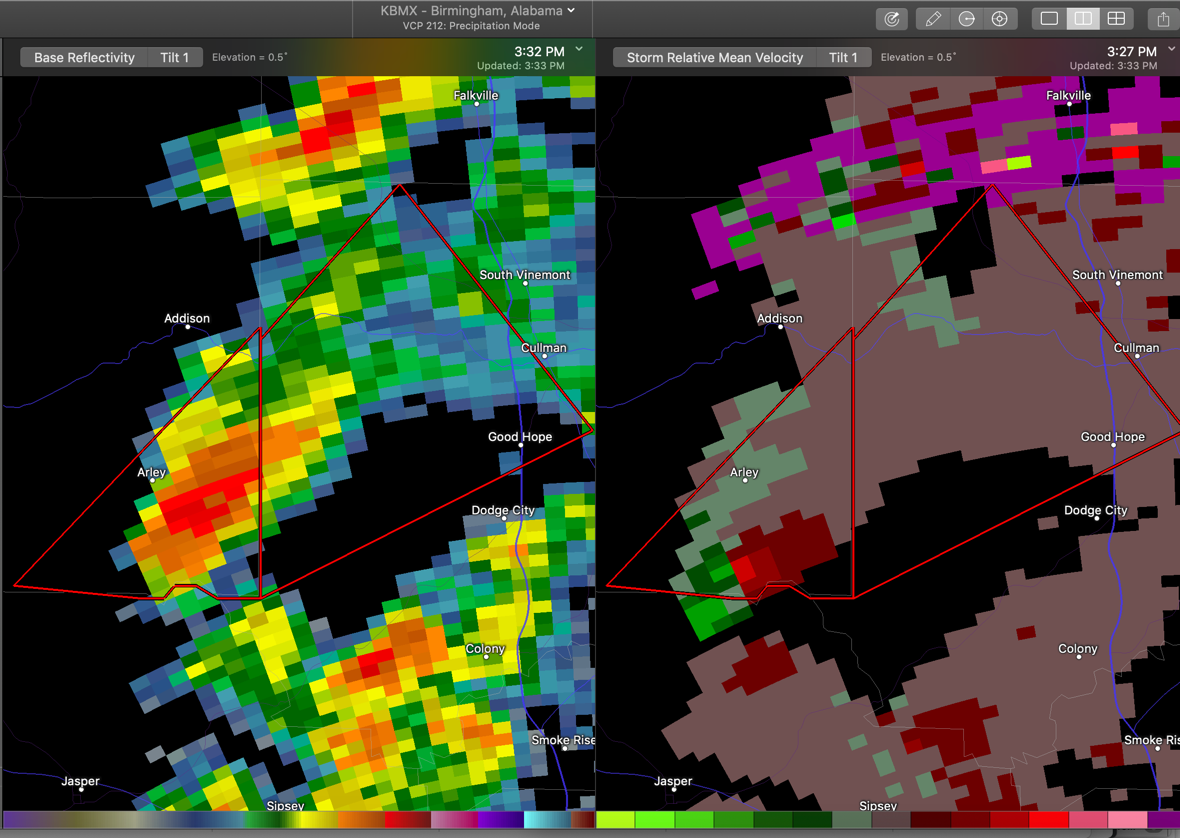
A tornado warning has been issued for the storm coming out of Walker County that prompted a tornado warning for that county. There have been reports of funnel clouds with this storm. It is moving toward the Vinemont and the city of Cullman right now. It will arrive there before 4 p.m.
Take cover now if you are in the polygon!

The National Weather Service in Huntsville Alabama has issued a
* Tornado Warning for…
Northwestern Cullman County in north central Alabama…
* Until 400 PM CST.
* At 331 PM CST, a severe thunderstorm capable of producing a tornado was located over Smith Lake, or near Arley, moving northeast at 40 mph.
HAZARD…Tornado.
SOURCE…Radar indicated rotation. The public has reported a funnel cloud or wall cloud over Smith Lake with this storm.
IMPACT…Flying debris will be dangerous to those caught without shelter. Mobile homes will be damaged or destroyed.
Damage to roofs, windows, and vehicles will occur. Tree damage is likely.
* Locations impacted include…
Cullman, Good Hope, Baldwin, West Point, Phelan, Logan, Crane Hill, Jones Chapel and Smith Lake.