


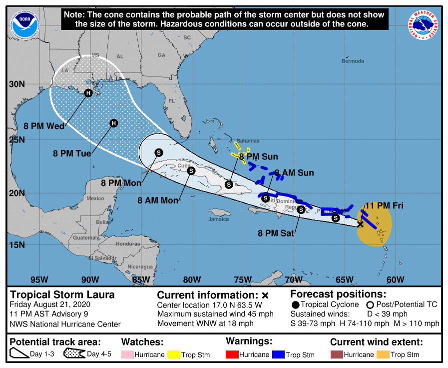
SUMMARY OF 1100 PM AST…0300 UTC…INFORMATION
LOCATION…17.0N 63.5W
ABOUT 195 MI…315 KM ESE OF SAN JUAN PUERTO RICO
MAXIMUM SUSTAINED WINDS…45 MPH…75 KM/H
PRESENT MOVEMENT…WNW OR 285 DEGREES AT 18 MPH…30 KM/H
MINIMUM CENTRAL PRESSURE…1008 MB…29.77 INCHES
WATCHES AND WARNINGS
A Tropical Storm Warning is in effect for…
* Puerto Rico, Vieques and Culebra
* U.S. Virgin Islands
* British Virgin Islands
* Saba and St. Eustatius
* St. Maarten
* St. Martin and St. Barthelemy
* The northern coast of the Dominican Republic from Cabo Engano to the border with Haiti
* The northern coast of Haiti from Le Mole St. Nicholas to the border with the Dominican Republic
* The southeastern Bahamas and the Turks and Caicos Islands
A Tropical Storm Watch is in effect for…
* The central Bahamas
DISCUSSION AND OUTLOOK
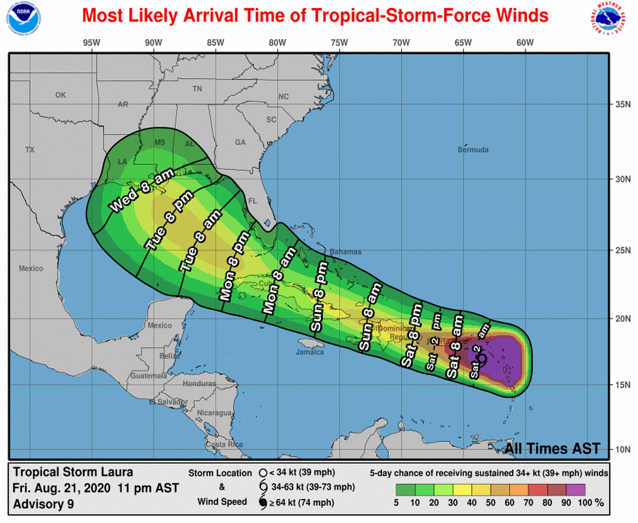
At 1100 PM AST (0300 UTC), the center of Tropical Storm Laura was located near latitude 17.0 North, longitude 63.5 West. Laura is moving toward the west-northwest near 18 mph (30 km/h) and a generally west-northwestward motion at a slightly faster forward speed is expected over the next few days. On the forecast track, the center of Laura will move near or over portions of the Leeward Islands tonight, near or over Puerto Rico Saturday morning, and near the northern coast of Hispaniola Saturday night and early Sunday.
Maximum sustained winds are near 45 mph (75 km/h) with higher gusts. Some slow strengthening is forecast during the next few days.
Tropical-storm-force winds extend outward up to 205 miles (335 km) from the center.
The estimated minimum central pressure is 1008 MB (29.77 inches).
HAZARDS AFFECTING LAND
RAINFALL: Laura is expected to produce 3 to 6 inches of rain over Puerto Rico and the Virgin Islands, the Dominican Republic, the southern Haitian Peninsula and eastern Cuba through Sunday. Maximum amounts up to 8 inches are possible along eastern portions and the southern slopes of Puerto Rico, as well as over Haiti, the Dominican Republic and eastern Cuba. This heavy rainfall could lead to flash and urban flooding, as well as an increased potential for mudslides with minor river flooding in Puerto Rico.
1 to 3 inches of rain with isolated maximum totals of 5 inches is expected over the northern Leeward Islands, the Turks and Caicos and southeast Bahamas.
WIND: Tropical storm conditions are expected within portions of the warning area area tonight through Sunday. Tropical storm conditions are possible within portions of the watch area Sunday night.
SURF: Swells generated by Laura are affecting portions of the northern Leeward Islands. These swells are expected to spread across the northern coasts of Puerto Rico, Hispaniola and Cuba, and much of the Bahamas during the next few days. Please consult products from your local weather office.
Information taken from the latest National Hurricane Center Public Advisory as of 10:00 pm.



