


An all new edition of the ABC 33/40 Weather Xtreme video is available in the player on the right sidebar of the blog. You can subscribe to the Weather Xtreme video on iTunes by clicking here.
THIS AFTERNOON: The heaviest rain in Alabama this afternoon has shifted to the south, generally along and south of U.S. 80 through parts of Marengo, Wilcox, and Dallas Counties at mid-afternoon, where the air is more unstable. Over the northern half of the state we are in rain cooler air after the morning round of storms; Anniston reports a cool 70 degrees at 2:00… that is over 20 degrees below average for August 9, and more representative of a high we could see in early January.
TONIGHT/TOMORROW: SPC maintains a slight risk of severe weather for the far northern part of Alabama tonight, as additional storms could move into the state from the north, ahead of a rather strong cold front for August. But, generally speaking, with a rain-cooled, stable airmass, we don’t expect much more than scattered light rain for places like Birmingham, Tuscaloosa, Anniston, and Gadsden over the next 6 hours of so.
Tomorrow, however, still looks relatively wet, with a good chance of showers and strong thunderstorms ahead of the front. It won’t rain all day, but the rain could come at any time, and like today a few heavy downpours are likely with the stronger storms. We won’t get out of the 80s because of the clouds and rain.
DRY AIR FOR THE WEEKEND: No change in our thinking for the weekend. Sunny days, lower humidity levels, and cooler nights. We drop into the 60 to 65 degree range early Sunday; some of the cooler spots could see the upper 50s across North Alabama. Doesn’t get any better in August thanks to the dry, continental air.
NEXT WEEK: Just a small risk of a shower Monday, then look for a better chance of showers and storms on Tuesday and through mid-week as moisture levels rise. See the Weather Xtreme video for more details.
TROPICS: Ernesto will move west into Mexico tonight, but now we have Tropical Depression 7 that has formed in the Atlantic. This should become Tropical Storm Gordon soon. The upgrade was right after I recorded the Weather Xtreme video, so below is the NHC forecast track…
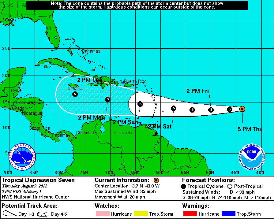
Way too early to determine if this will enter the Gulf of Mexico. Just something to watch in coming days.
Also, a strong tropical wave has moved off the coast of Africa; that will be one to watch as well.
WEATHER BRAINS: Don’t forget you can listen to our weekly 90 minute netcast anytime on the web, or on iTunes. This is the show all about weather featuring many familiar voices, including our meteorologists here at ABC 33/40.
CONNECT: You can find me on all of the major social networks…
Look for the next Weather Xtreme video here by 7:00 a.m. tomorrow….



