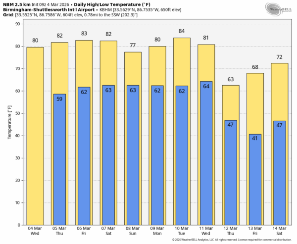
WARM DAYS AHEAD: We expect afternoon temperatures to reach the low to mid 80s across much of Alabama through Saturday. Easily the warmest weather so far this year, and a few spots could establish new daily record highs. The weather will be dry today as an upper high continues to build over Florida.
We will bring in some risk of isolated showers tomorrow afternoon over South Alabama, and few isolated showers are possible statewide Friday. Nothing widespread or heavy.
THE ALABAMA WEEKEND: Showers during the day Saturday will remain widely spaced, but there will be an increase in rain coverage late in the day, Saturday night, and into Sunday as a surface front approaches and stalls out northwest of Alabama. A few thunderstorms are possible, but they should remain below severe limits. The weekend won’t be a wash-out, but be ready for some rain at times. The high Saturday will be in the low to mid 80s, Sunday’s high will be in the 75-82 degree range.
NEXT WEEK: A few showers are possible Monday and Tuesday, but an organized batch of rain and thunderstorms will move into the state Wednesday and Wednesday afternoon ahead of a cold front. There will be potential for strong, possibly severe thunderstorms, but it is way too early for details. Noticeably cooler air will follow the front with highs in the 60s Thursday and Friday; colder spots across North Alabama could drop into the 30s by Friday morning (March 13). See the video briefing for maps, graphics, and more details.
ON THIS DATE IN 1943: A late season Arctic airmass was in place across the Deep South. The low in Huntsville was 7 degrees, Birmingham dropped to 17.
ON THIS DATE IN 2008: Two EF-1 tornadoes touched down in West Alabama during the early morning hours; one near Eutaw in Greene County, the other near Samantha in northern Tuscaloosa County.
Look for the next video briefing here by 3:00 this afternoon… enjoy the day!