


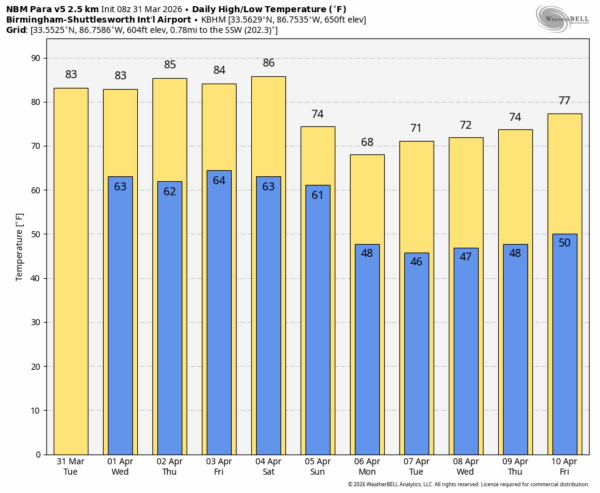
WARM DAYS: Afternoon highs will be in the 80-85 degree range across most of Alabama daily for the rest of the week with partly sunny days and mostly cloudy nights. Each day a few isolated showers are possible during the afternoon and evening hours, but the chance of any one spot getting wet is only 15-25 percent. March is going out like a lamb.
EASTER WEEKEND: The weather won’t change much Saturday. Warm with highs in the 80s and just a handful of isolated afternoon showers. Then, on Sunday, a cold front will pass through the state with an organized band of showers and thunderstorms. With limited instability and the best dynamic support well to the north, at this point the risk of severe storms looks relatively low. Rain amounts will be around 1/2 inch for most locations; best chance of rain Sunday over North Alabama will come during the morning, then shifting into the southern counties by afternoon.
NEXT WEEK: At this point the week looks generally dry with highs mostly in the 70s, lows in the 40s. Still no sign of any late season freeze threat for the next ten days… See the video briefing for maps, graphics, and more details.
ON THIS DATE IN 1933: A massive F4 tornado cut a devastating 25-mile swath across Jones, Jasper, and Clarke Counties in Mississippi. The tornado left 37 dead and 170 injured that morning.
ON THIS DATE IN 1962: At least ten tornadoes touched down across the Deep South. An F2 tornado struck Bon Secour in Baldwin County, where homes were heavily damaged and trees were uprooted. It continued eastward to near Foley, where more homes and buildings were damaged or destroyed. A large, destructive tornado moved through Milton, Florida, killing 17 and injuring over 100.
Look for the next video briefing here by 3:00 this afternoon… enjoy the day!



