Daily Weather Briefing
Sunday, September 27, 2026
ALABAMA THIS MORNING
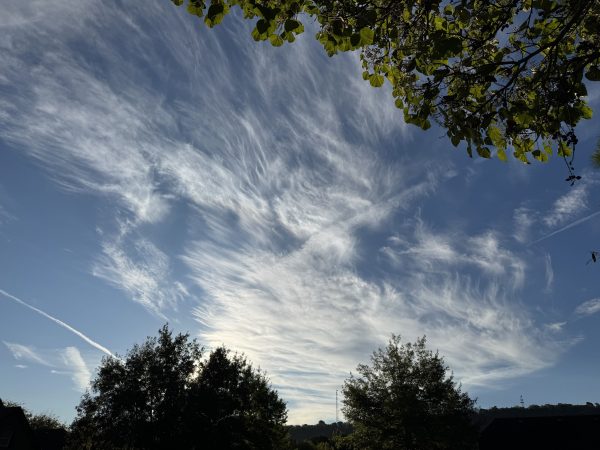
Parts of northwest and south Alabama see partly to mostly cloudy skies, while the rest of the state sees mostly clear skies. No rain is on the radar, and temperatures are in the upper 50s to lower 60s in the north and the low to mid 60s across the rest of the state. Coastal Alabama is in the 70s. Skywatcher Joey Amberson in Oxmoor Valley sent in this picture of the morning cirrus clouds in the area.
ALABAMA 7 DAY FORECAST
Alabama sits between an upper-level ridge to the west and an upper-level trough to the east, causing northwesterly flow into the region, keeping the air less hot and drier through the beginning of this week. We will slowly shift into a warmer pattern later this week as the upper-level ridge spreads into the region.
DRY START TO THE WEEK – Sept 27-29
Today through Tuesday will see rain chances stay at zero as the drier air sticks around.
Today, highs will reach the low to mid 80s in the north nd the mid to upper 80s in the southern two-thirds of the state. Skies will be partly cloudy to mostly clear, especially as we head into the afternoon.
Lows will be quite pleasant across the state Monday morning, ranging from the mid 50s in the northeast to the low 60s in the southwest. Highs will warm up to be in the low to mid 80s north, mid 80s over central Alabama, and the upper 80s in the south. Skies will continue to be in partly cloudy to mostly clear.
Tuesday will be warmer in terms of highs as the low 90s return for most of the state, but the mid to upper 80s hang on in the north, and a few locations in the south stick to the upper 80s as well. Before these hot temperatures occur, however, morning lows will be in the mid 50s north to the low 60s south.
HOT WITH SLIGHTLY HIGHER RAIN CHANCES TO END THE WEEK – Sept 30-Oct 3
Heading into the second half of the week, the upper-level ridge will begin to have more influence on the state, keeping us warmer and bringing us slightly higher chances of rain. The good news is dew points will stay on the lower side, so we won’t be nearly as humid with these hotter temperatures as we were earlier this month.
On Wednesday, rain chances stay at zero in the northern half of the state and increase to 20% in the southern half of the state. Any showers that develop in the region will occur in the afternoon and evening and be isolated in nature. Highs will be in the upper 80s to low 90s in the north and the low 90s over the rest of the state. Dewpoints will be in the 50s to 70s from north to south.
The low 90s persist into Thursday, and dewpoints will increase into the 60s. There is a 10% chance of afternoon isolated showers or thunderstorms.
The upper 80s return to the western third of the state by Friday, while the eastern two-thirds still reach the low 90s. Dewpoints in the 60s north and 70s south are expected. The 10% chance of rain continues into Friday as well.
The mid 80s are expected over most of north Alabama on Saturday, while the upper 80s dominate the rest of the state. Rain chances will stay at 10%.
RAINFALL OUTLOOK
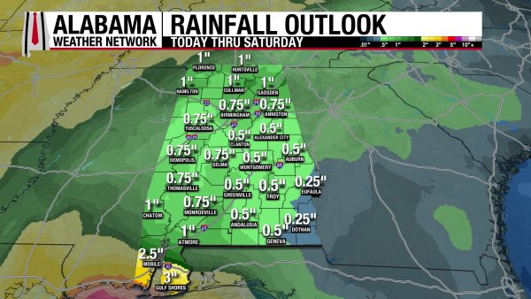
Over the next week, rainfall amounts across most of Alabama will be between half an inch and an inch. The southeast corner of the state will stay a little drier while the coast will be wetter, as it is expected to receive 2 to 3″ of rain. Most of this rain will not fall until Friday and Saturday of this week, and the majority of this week will be dry.
THE ATLANTIC
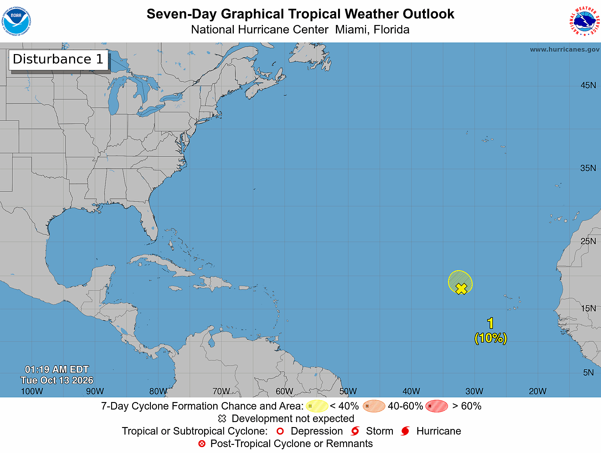
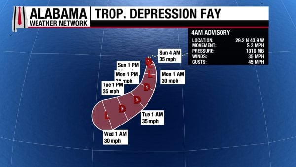
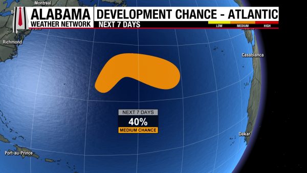
In the Atlantic, Tropical Storm Gonzalo has dissipated while Tropical Depression Fay still holds on. It has sustained winds of 35 mph and a central pressure of 1010 mb. It is forecast to move south-southwest over the first half of this week, teetering between post-tropical depression and tropical depression status. In the Central Subtropical Atlantic to the north of Fay, there is a disturbance that has a 40% chance of developing into a tropical system over the next week.
THE PACIFIC
The Pacific is very busy with 3 hurricanes, a tropical depression, and a disturbance!
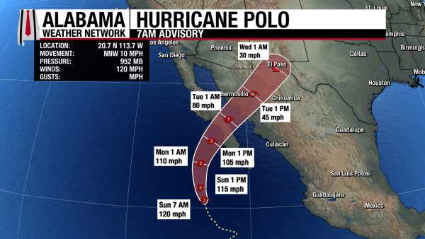
Hurricane Polo, which has weakened to a Category 3 hurricane with sustained winds of 120 mph and a central pressure of 952 mb, will curve to the northeast by tomorrow as it continues to weaken. It looks to make landfall sometime Monday evening in Baja California Sur. Advisories from Tropical Storm Watches to Hurricane Warnings are active for the area as the region will begin to receive tropical storm-force winds Monday afternoon before the hurricane-force winds arrive later in the day. The region is also expected to receive 4-8″ to locally higher amounts of 10″ as the storm passes, which will lead to flash flooding and mudslides. Storm surge and large swells are a danger as well.
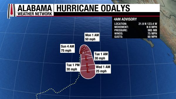
Category 1 Hurricane Odalys has sustained winds of 75 mph and a central pressure of 985 mb, but it is expected to weaken to tropical storm strength later this afternoon. It will take a sharp turn south thanks to Polo and will be a post-tropical depression by Tuesday.
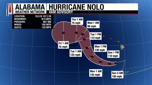
Hurricane Nolo is a Category 2 storm with sustained winds of 100 mph and a central pressure of 967 mb. The worst effects of Nolo on Hawaii have passed, but 1-2 inches of rain is still possible for the majority of the islands; winds will still be strong and gusty, and large swells will persist today. Nolo will strengthen into a major hurricane (3+) tomorrow, and it moves west-northwest away from Hawaii.
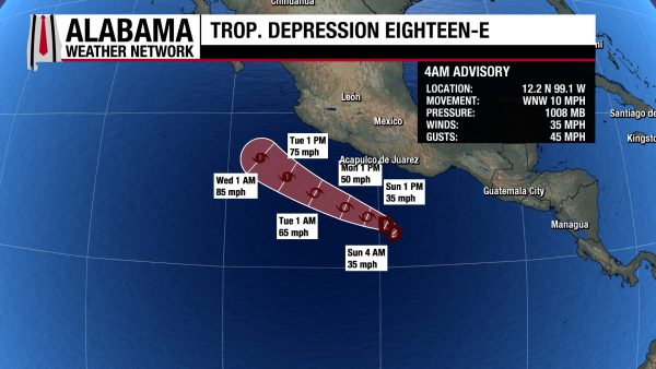
Tropical Depression Eighteen-E sits off the southern coast of Mexico with sustained winds of 35 mph and a central pressure of 1008 mb. The storm is expected to strengthen to a tropical storm tomorrow and a Category 1 hurricane by Tuesday afternoon. No impacts to land are expected as of now.
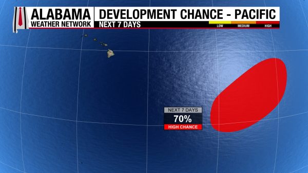
As if all of these storms weren’t enough, there is a disturbance sitting well southeast of Hawaii that has a 70% chance of development over the next week.
ENJOYABLE BEACH WEATHER THIS WEEK
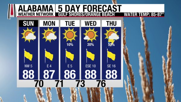
Today through Wednesday feature great beach conditions: highs in the mid to upper 80s, winds from the northwest (today) and east (rest of week) at 5-10 mph and rain chances between zero (today and tomorrow) and 20% (Tuesday and Wednesday). Skies will be mostly sunny each day, and the rip current risk is Low today with a surf height of 1 foot. Thursday sees rain chances increase to 50%.

WEATHERBRAINS 1080
Tomorrow’s WeatherBrains features Josh Morgerman, legendary hurricane chaser, who will talk about his experience with tropical cyclones. Listen to the episode wherever you get your podcasts or watch it here!
TODAY IN WEATHER HISTORY
September 27, 2024 – Hurricane Helene
Hurricane Helene approached Florida as an unusually large, fast-moving hurricane, strengthening rapidly during its final hours over the eastern Gulf of Mexico. Warm water, abundant atmospheric moisture, and low wind shear allowed its inner core to tighten quickly, while its sprawling circulation ensured that damaging weather would extend far from the eye. The National Hurricane Center specifically warned that Helene’s rapid forward motion could carry destructive winds unusually far inland. By late evening, reconnaissance aircraft found the central pressure falling rapidly as Helene reached Category 4 intensity.
At 11:10 p.m. EDT on September 27, 2024, Helene’s eye crossed the Florida Big Bend just east of the mouth of the Aucilla River, about 10 miles west-southwest of Perry. Maximum sustained winds were estimated at 140 mph. The operational landfall update reported a central pressure of 938 millibars, or 27.70 inches, while the National Hurricane Center’s later post-storm analysis assigned a landfall pressure of 939 millibars. Helene became the strongest hurricane on record to strike Florida’s Big Bend region. At the DoubleTree in Tallahassee, my lowest pressure observation was 28.63 inches.
Along the coast, the wind was only part of the disaster. Helene drove a catastrophic storm surge into the Big Bend, with inundation exceeding 15 feet above normally dry ground in some locations. Keaton Beach, Steinhatchee, Dekle Beach, and surrounding coastal communities suffered extraordinary destruction. Homes were torn from foundations, structures were reduced to debris, and some of the hardest-hit communities saw entire neighborhoods devastated.
Helene then raced northward instead of quickly spinning down over land. Its speed allowed destructive winds to penetrate across north Florida and deep into Georgia during the overnight hours. Trees were snapped, uprooted, and hurled onto homes, vehicles, and power lines. The saturated ground made the danger even greater farther north. The National Hurricane Center ultimately attributed dozens of direct deaths to wind, most involving falling trees, making wind an unusually deadly component of Helene.
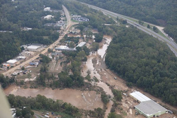
But an even larger catastrophe was developing in the southern Appalachians. The mountains had already been soaked by heavy rain ahead of Helene, leaving rivers elevated and soils saturated. As Helene’s deep tropical moisture encountered the Blue Ridge, moist air was forced upward over the terrain, intensifying the rainfall. Busick, North Carolina, recorded 30.78 inches, the largest storm-total rainfall documented in the National Hurricane Center’s post-storm report.
Water poured down steep slopes and into narrow valleys with devastating speed. The French Broad River at Asheville crested at 24.82 feet, surpassing the record established during the historic flood of 1916. The Swannanoa River at Biltmore Village reached 27.33 feet, more than six feet above its previous record. Portions of Interstate 40 washed away, bridges disappeared, utilities failed, landslides scarred the mountains, and entire communities were temporarily cut off from the outside world.
Helene’s final statistics reflected the extraordinary breadth of the disaster. The hurricane caused an estimated $78.7 billion in damage and was associated with roughly 250 deaths, with some later tallies placing the total at 252. It became the deadliest Atlantic hurricane since Maria in 2017 and the deadliest hurricane to strike the U.S. mainland since Katrina in 2005. Helene was not simply a Florida landfalling hurricane; its surge, wind, rainfall, flooding, and landslides created a disaster stretching hundreds of miles inland.
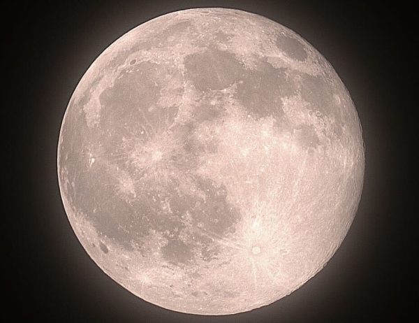
IMAGE OF THE DAY
Skywatcher Daniel Harbin captured the full Harvest Moon, the full moon that aligns with the timing of the autumnal equinox, last night!