


WARMER: Afternoon highs return to the 80s across Alabama each day through the weekend; today will be another dry day with a good supply of sunshine. We will mention the chance of a few spotty showers across the far southern part of the state tomorrow, the day will be dry with a partly to mostly sunny sky.
Thursday will be warm and dry, and then on Friday we will bring in the chance of scattered showers over the southwest counties.
THE ALABAMA WEEKEND: A disturbance will bring a round of showers and thunderstorms Friday night into part of the day Saturday. At this point it looks like the best chance of rain over the northern half of Alabama will come Friday night into Saturday morning, then shifting into the southern counties Saturday afternoon and evening. For any one given spot understand it won’t rain all day Saturday, and the high will be in the low 80s.
The weather will be drier Sunday. A few widely scattered showers are possible, mainly over the southern half of the state. With a mix of sun and clouds we project a high in the 80-84 degree range.
NEXT WEEK: The pattern will be active. SPC has defined a risk of severe thunderstorms Monday (April 27) for much of North and West Alabama…
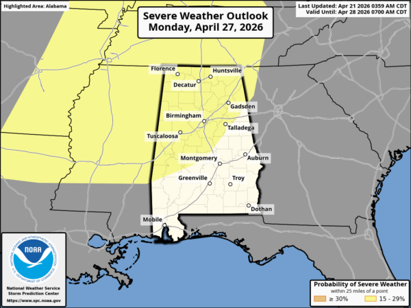
It is way too early to be specific, but a very unstable airmass will be place, and with some decent dynamic support severe storms are definitely possible Monday afternoon/evening. On the positive side, seven day totals are now expected to be in the 2-3 inch range over North Alabama, with 1-2 inches for the southern counties. This is badly needed rain.
There will be other days with showers and storms around during the week… See the video briefing for maps, graphics, and more details.
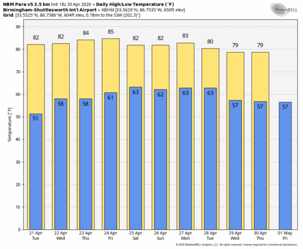
RACE WEEKEND: Friday will be a warm, dry day at Talladega. A few showers and thunderstorms are likely Saturday; for now it looks like the best chance of rain will come during the morning hours. Then, on Sunday, the weather looks much better with just a small risk of a shower during the day. Highs will be in the low 80s, lows mostly in the 60s.
ON THIS DATE IN 1967: Tornadoes hit Illinois. An F4 occurring at 3:50 pm left 24 dead and 500 injured. Seven people were killed at a shopping center, and at least 13 were killed at Belvidere High School. Another F4 at 5:24 pm, left 33 dead and 500 injured. This funnel hit Palos Hills, Oak Lawn, Hometown, and Evergreen Park on the southwest side of Chicago.
Look for the next video briefing here by 4:00 this afternoon… enjoy the day!



