


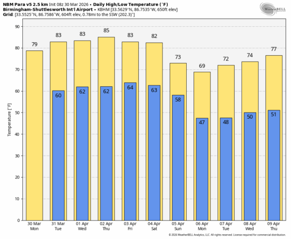
WARMER: Afternoon temperatures will reach the low 80s across South Alabama today, with upper 70s to the north. Then, we expect highs in the 80s statewide tomorrow through Friday as the warm-up continues.
Most of Alabama will be dry today; just a small risk of a brief shower over the southern quarter of the state. A few spotty showers are possible tomorrow, mainly across Southeast Alabama.
Then, we will mention the risk of showers statewide Wednesday through Friday, but the showers will likely be widely spaced, and rain amounts will be light and spotty.
THE ALABAMA WEEKEND: Not much change Saturday; warm with just a few isolated showers around. Temperatures will rise into the 80-85 degrees. Then, on Sunday, a cold front will bring an organized band of showers and storms through Alabama. With the main dynamic support well to the north, the chance of severe storms looks low at this point, and rain amounts will be generally 1/2 inch or less. Highs drop into the low to mid 70s over the northern half of the state as cooler air arrives behind the front.
The weather will be cooler statewide early next week with lows in the 40s, but at this time the chance of frost looks low. See the video briefing for maps, graphics, and more details.
ON THIS DATE IN 1938: Ten people were killed and 200 injured when an F4 tornado devastated Columbus, KS. The tornado first touched down in Oklahoma… in the community of Hollow a school was destroyed, but all the students were uninjured.
ON THIS DATE IN 1977: Two tornadoes touched down in DeKalb County, including an EF-3 that tore through Geraldine. Three small homes, 2 trailers, and 11 farm buildings were destroyed; two people were injured. The other was rated EF-2, and moved through the Fishers Crossroads community near Fort Payne.
Look for the next afternoon briefing here by 3:00 this afternoon… enjoy the day!



