


Daily Weather Briefing
Sunday, March 29, 2026
ALABAMA THIS MORNING
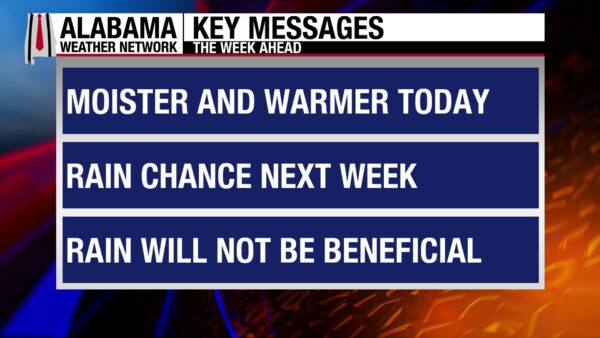
Skies are mostly clear throughout north and central Alabama this morning, while parts of south Alabama have pockets of cloudy skies. Winds are still gusty this morning, hitting 15 to 27 mph across the state. Temperatures sit in the upper 40s and low 50s in the north, low to mid 50s centrally, and mid to upper 50s in the south.
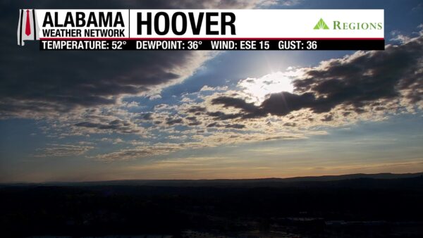
The rising sun is blocked by stratocumulus clouds in Hoover this morning.
ALABAMA 7 DAY FORECAST
Today will be gusty at times, but southeasterly flow will slowly increase moisture in the atmosphere, and temperatures will be warm. Tomorrow and Tuesday will be warmer, and low chances for isolated showers enter the forecast. Wednesday sees a medium chance of isolated to scattered showers and thunderstorms in response to a cold front moving toward (but not into) the state. Rain chances decrease to low again Thursday, then increase to medium Friday as a shortwave approaches the region. Rain chances are similar Saturday. Highs remain warm the entire week.
FIRE DANGER SUBSIDES TODAY
Despite still gusty winds blowing from 15-25 mph at times, increasing moisture advection from the southeast has made yesterday’s fire threat subside. Skies will be overcast for the most part, with a few breaks of sunshine possible. Today will still be dry, and highs will climb into the mid to upper 60s in the eastern two-thirds of the state and the lower 70s in the western third.
CLOUDY NIGHT
Clouds will persist throughout the night, and lows will fall to the low to mid 50s except for the coast, which will sit in the low 60s.
80s RETURN MONDAY
Winds will finally calm some on Monday, and southeast flow will turn more southerly throughout the day. This will allow highs to increase to the upper 70s in the north and east and to the lower 80s in the south and west. There is a very low chance of light isolated showers across the state.
RAIN CHANCES INCREASE TUESDAY
Shower chances increase slightly Tuesday, especially in the south. They will still be isolated in nature. Highs will sit in the low 80s statewide.
RAINY-ER WEDNESDAY
As a cold front nears the state, moisture availability increases further. This will allow for scattered shower and thunderstorm chances to increase to a medium level Wednesday. No severe thunderstorms are forecast. Highs will be in the low 80s once again.
SLIGHTLY DRIER THURSDAY
Rain chances dwindle momentarily on Thursday, with only a 20% chance of showers and thunderstorms forecast across the state. Highs will take this opportunity to reach the low 80s in the northern half of the state and the mid 80s in the southern half.
INCREASE IN RAIN CHANCE FRIDAY/SATURDAY
Another shortwave/cold front system will approach the state on Friday, increasing rain and thunderstorm chances back to a medium level through Saturday. Friday’s highs will be in the upper 70s west and the lower 80s in the east. Saturday will feature highs in the low 80s across the board.
BREAK IN THE FAIR-WEATHER PATTERN
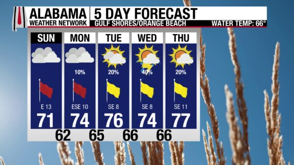
After a long stretch of fair weather on the beach, not-so-fair conditions ruin the streak. The change to a southeasterly flow has caused a high rip current risk that will last through Monday. The surf of 3 to 5 feet will be dangerous to all swimmers. In addition to the rougher waters, skies will be mostly cloudy for most of the day, only switching to partly sunny in the afternoon. Winds will blow at 15 mph. A high in the low 70s stands out as the best condition expected today. Rain chances increase throughout the week.

WEATHERBRAINS 1054
Tomorrow’s WeatherBrains episode hosts Oklahoma University’s Professor Emeritus, Howie Bluestein. He will dig into the five decades of storm research he’s done. Listen to the episode wherever you get your podcasts or watch here.

TODAY IN WEATHER HISTORY
March 29, 1991 – Tornadoes and a Downburst
Severe storms moved across Alabama during the early morning hours, producing tornadoes and a powerful downburst that caused significant damage. Just after 4:15 a.m., a strong microburst struck the Birmingham metropolitan area, beginning near Bessemer, where trees were blown down and buildings damaged. Winds gusted to 69 mph at the National Weather Service office on West Oxmoor Road as the microburst carved a damage path roughly 0.25 to 0.50 miles wide and 7 to 8 miles long. Hundreds of large trees were blown down across Homewood, Mountain Brook, and Crestline, damaging homes, vehicles, and structures. The Birmingham Zoo, Birmingham Botanical Gardens, and Birmingham Country Club were especially hard hit, and total damage from the downburst was estimated at $5 million. Remarkably, no injuries or fatalities occurred in the Birmingham area from the microburst. Farther east, tornadoes produced deadly and destructive impacts. Around 5:30 a.m., an F1 tornado struck the town of Munford in Talladega County, destroying eight manufactured homes. A family of four was killed when their trailer was lifted and carried by the storm, and another person died in a separate mobile home, bringing the death toll to five with 13 injuries reported. An F2 tornado struck Ladonia in Russell County around 6:40 a.m., damaging 55 homes, destroying 16 of them, overturning two trucks, and damaging a church and several businesses while injuring 16 people. Later that morning, an F1 tornado near Goodway in Monroe County moved a house off its foundation, flipped four vehicles, damaged barns and farm equipment, and uprooted many trees. Other tornadoes touched down across the Southeast that day, but only the Munford tornado caused fatalities. The 29th was the last day of a three-day tornado event across the East, with only two other fatalities occurring on the 27th in Wisconsin and Indiana.

IMAGE OF THE DAY
@dittogrome on X tagged James Spann in this awesome photo of the sunset in Daphne last night.



