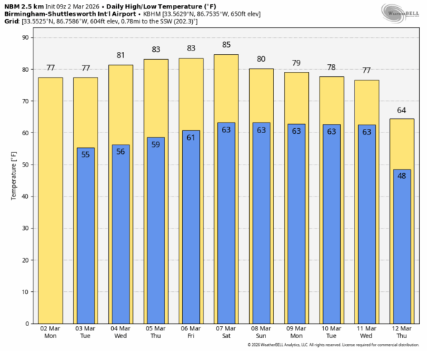
EARLY THIS MORNING: The sky is generally cloudy over the northern half of Alabama early this morning with a few sprinkles; South Alabama is mostly clear. Most of the state will be dry today with temperatures reaching the 75-80 degree range this afternoon.
Look for the warmest weather so far this year across the Deep South in coming days. All of Alabama will likely see highs in the 80s Wednesday through the weekend… a few communities across the southern counties might even flirt with the 90 degree mark. The warmth is due to an upper high developing along the South Atlantic coast; this same feature will keep most of the organized rain and thunderstorms well to the north and west of Alabama. Showers around here this week will be few and far between.
THE ALABAMA WEEKEND: Not much change; the weather will be warm and dry with highs generally in the 80s. Any afternoon showers will remain isolated.
There is good evidence from global models that the upper ridge will break down next week, meaning our weather will become more active with several rounds of rain and storms likely. Too early to know if we will have a severe weather threat, but this is March and we will watch model trends closely. See the video briefing for maps, graphics, and more details.
ON THIS DATE IN 1942: Much of North and East Alabama was covered by a blanket of snow, much of Cleburne County had over ten inches.
ON THIS DATE IN 2012: Several tornadoes touched down across Alabama, including an EF-2 that moved through Tallapoosa and Chambers counties that killed one person and injured two others. The strongest tornado of the day was an EF-3 in Limestone and Madison counties. The most intense damage occurred near Hazel Green, where several homes had roofs torn off and walls collapsed, and three were reduced to rubble. An EF-2 in Madison county damaged Buckhorn High School.
Look for the next video briefing here by 3:00 this afternoon… enjoy the day!