


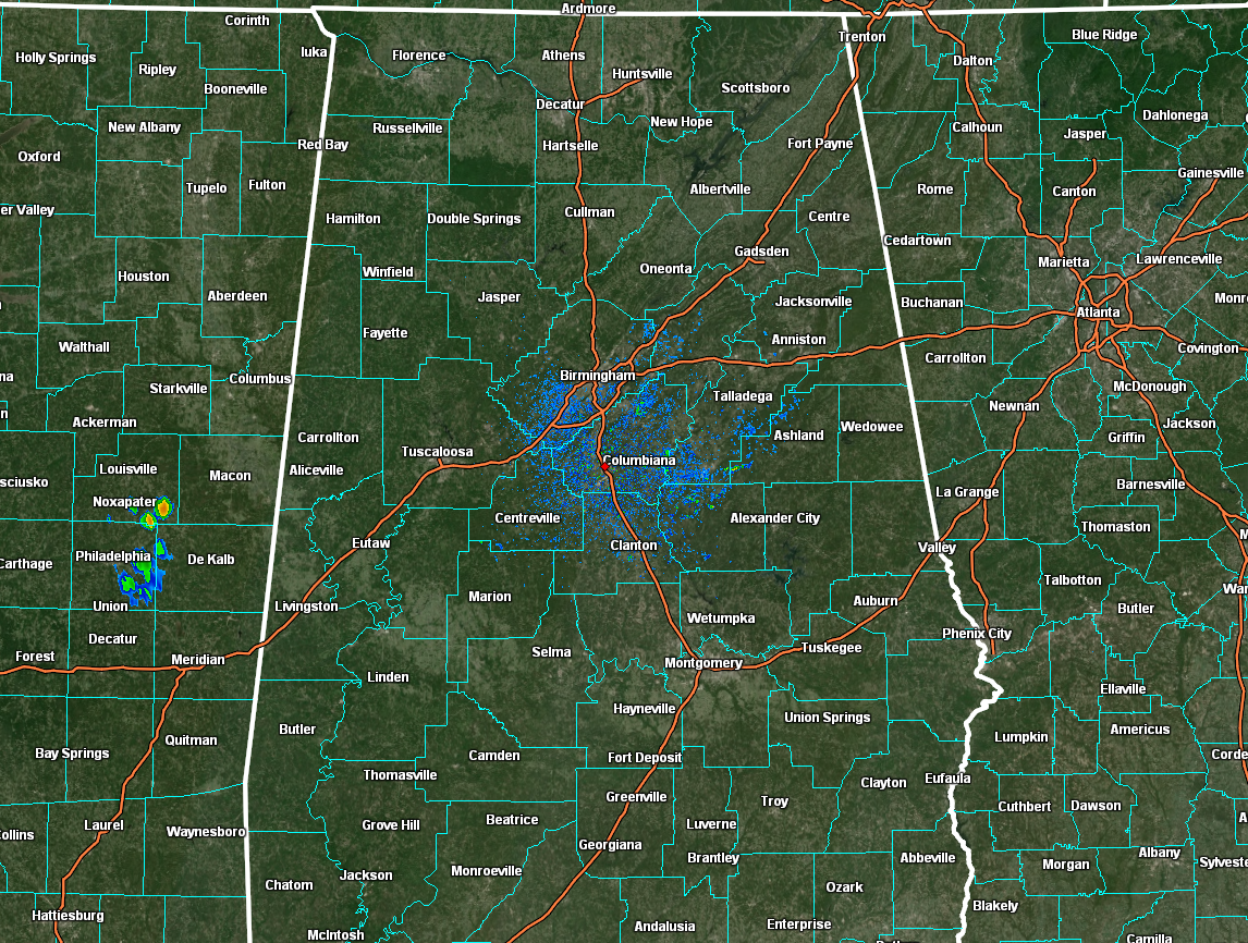
THIS MORNING: Radar at 5 am this morning shows that all of Central Alabama is dry for now, but don’t be surprised to see activity starting to form with the heating of the day today. Temperatures as of the 5 o’clock round up were in the upper 60s to the mid 70s across the area. Haleyville was the cool spot at 69º. Troy and Montgomery were tied for the warm spots at 75º. Birmingham was at 73º.
THIS WEEKEND: Today looks to be your typical late summer day in Central Alabama as we’ll have partly sunny skies with scattered showers and storms possible during the afternoon and evening hours. Most of the activity will take place over the northern half of the area. Afternoon highs will be in the upper 80s to the mid 90s.
Sunday looks to be much of the same, but rain chances look to be a little higher. Scattered to numerous showers and storms for the area, with the higher coverage of storms over the northern half. Highs in the upper 80s to the lower 90s.
THE WORK WEEK AHEAD: On Monday, we’ll have a cold front moving into the northern half of the area and Fred will begin to move onshore with tropical moisture moving up into the southern parts of the area. For much of Central Alabama, we’ll have the potential for scattered to numerous showers and storms with slightly cooler temperatures. Highs in the lower to mid 80s for most.
Tuesday shows the front moves back to the north out of the area as a warm front and the center of Fred moves into Central Alabama. While the GFS is not giving Fred much to look at, the European shows a much better organized Fred bringing gusty winds, heavy rain, and the potential for a brief spin-up tornado or two. For now, wind gusts only look to reach 35-40 mph, mainly for locations close to and just east of the center of Fred. Locations southwest of the center may see rain end quickly for the most part. Highs will be in the mid to upper 80s.
While Fred will be out of the area on Wednesday, he will leave very moist air in his wake. We’ll return to scattered to numerous showers and storms becoming likely by the afternoon hours, with highs in the mid 80s to the lower 90s. Not much change for Thursday and Friday… scattered to numerous showers and storms become likely by the afternoon. Highs in the mid 80s to the lower 90s.
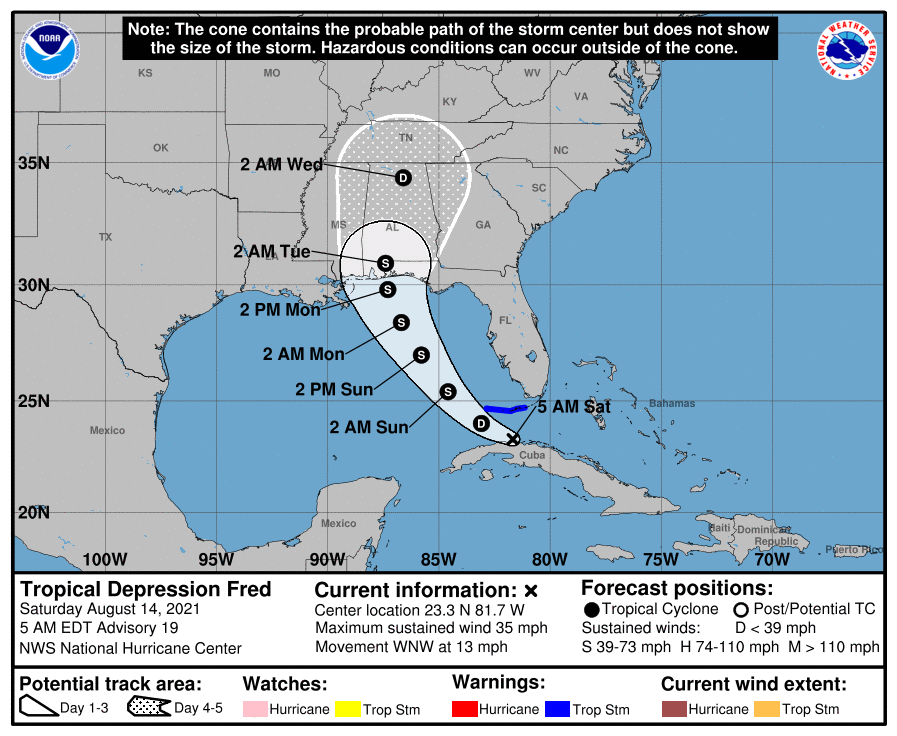
TROPICAL DEPRESSION FRED: Fred remains a tropical depression this morning, as he looks very disorganized. The National Hurricane Center has even stated that Fred may have transitioned into an open wave, but will wait for the latest information to come in from the hurricane hunter aircraft. Maximum sustained winds are at 35 mph and was moving to the west-northwest at 13 mph.
Fred will eventually get his act together, reorganize, and become a tropical storm again by Sunday afternoon. Landfall on the Gulf Coast is now projected to take place close to Orange Beach or Pensacola, with winds around 60 mph. Watches may be issued later today for portions of the northern Gulf Coast. There is a slight risk for flash flooding due to the heavy rains from Fred along the Gulf Coast, as totals could reach as high as 3-6 inches, with heavier localized amounts. The biggest threats to the Alabama and western Florida Panhandle Gulf Coasts will be from gusty winds, rough surf, deadly rip currents, and heavy rain. A few brief spin-up tornadoes and waterspouts will be possible as well.
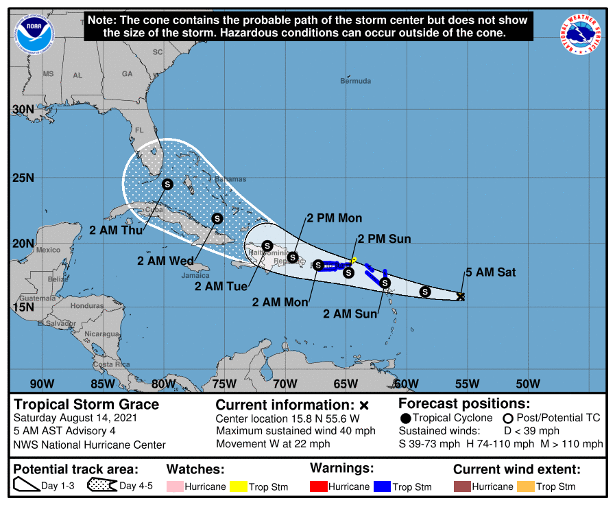
TROPICAL STORM GRACE: We also have newly formed Tropical Storm Grace out there around 400 miles to the east of the Leeward Islands with maximum sustained winds at 40 mph. Grace was moving to the west at 22 mph. The hurricane center track is rather similar to what Fred’s was a few days ago, but just a few miles north. Grace is expected to stay at tropical-storm-strength through Tuesday, as it will be approaching the Florida Keys. We’ll get a better focus on Grace after Fred moves out of the area, but guidance does show the potential of Grace moving into the Gulf of Mexico on Wednesday.



