It was a rather wet overnight period for North and Central Alabama with widespread rainfall that totaled generally a third of an inch for many locations. At sunrise, the radar was fairly active across the state with the bulk of the rain in an area from Birmingham to Montgomery to Columbus, GA, to Rome, GA, and back to Birmingham.
For folks heading to the beaches of Alabama and Northwest Florida, clouds and rain will prevail through the middle part of the week. Highs will be in the 60s, while lows will be in the upper 40s and lower 50s. Late in the week, the highs will fall into the 50s as the weather turns drier. See the complete Gulf Coast 7 Day Planner here.
The closed low over northern Mexico slowly moves into Texas today and tonight while a trough in the northern stream moves quickly by. This should lead to a bit of a break in the rain this evening and into early Monday, but the clouds stick around and the easterly flow keeps us cool today and tonight.
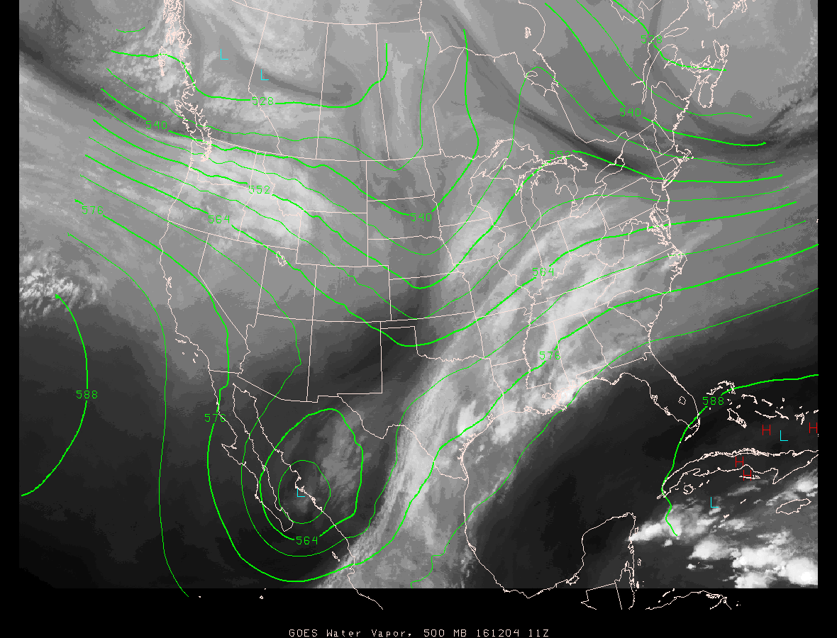
That closed low ejects northeastward Monday and Tuesday as a surface low forms in the Northwest Gulf of Mexico and moves northeastward into the southern Appalachians. The SPC has outlined a slight risk for severe storms along the Gulf Coast from Southeast Louisiana across southern Mississippi and Southwest Alabama into the Florida Panhandle. A marginal risk for severe weather extends northward into Central Alabama but is kept south of Birmingham. It looks likely that the highest CAPE values will remain along the Central Gulf Coast, but the GFS also showed a brief surge in CAPE values along and just ahead of the front as it moves across Central Alabama during the morning Tuesday. This will need to be watched for the potential for severe weather. Temperatures should surge well into the 60s early Tuesday morning as the warm front makes its way by us.
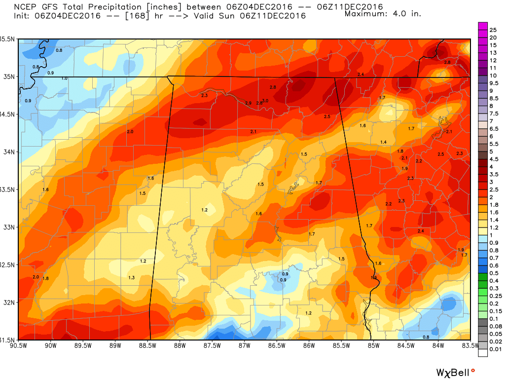
Rainfall during the next couple of days is still expected to be in the range of 1.5 inches to 3 inches across much of North and Central Alabama. Like the last event, this will help to put a good dent in the drought conditions, but even with good rains, our deficit will still be 5 to 7 inches.
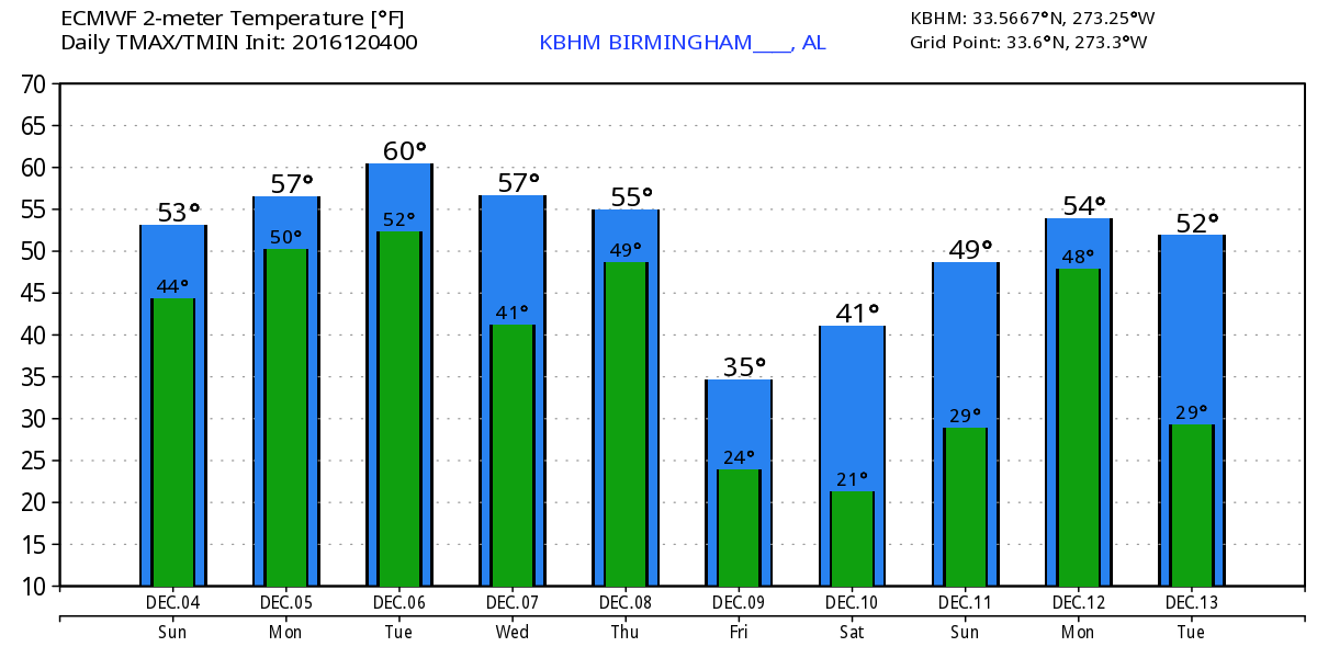
The upper trough zips out of the picture late Tuesday and Wednesday, so we should see our weather dry out for the afternoon Tuesday and Wednesday. This is where we run into model differences between the GFS and the ECMWF. A broad trough comes across the eastern US Thursday with a surface low in Canada. A cold front is forecast to move briskly across the eastern US on Thursday. The GFS is very conservative on rain potential for Thursday while the ECMWF is much more bullish bringing another round of rain and storms across the Southeast. For now, with confidence on the amount of showers somewhat low, I’ll stick with low percentage probabilities for rain on Thursday.
But as the upper trough sharpens up into Friday, our temperatures are forecast to plunge. I expect to see morning lows dip into the 20s with daytime highs mainly in the 40s.
Weak ridging occurs Saturday but we should still stay chilly but dry. A fast moving upper trough comes out of the northern Rockies on Sunday and promises a round of showers for Sunday with a cold front moving through the Southeast US. Moisture is not expected to be nearly as plentiful as our current pattern, so rainfall is not expected to be very high. By Sunday we should be moderating a little with highs into the 50s.
The GFS was promising us a really cold pattern for week 2 or voodoo country on the run yesterday. That is completely off the table with this run. In fact, the week 2 period is dominated by strong ridging across the eastern half of the country. If this verifies, we’d see warmer than typical temperatures and a number of days of dry weather.
I had a great time yesterday emceeing the Helena Christmas Parade. Sprinkles occurred during the parade, but those sprinkles didn’t dampen the crowds as people hung around until Santa came by on the Helena fire truck. James Spann will be back with the next edition of the Weather Xtreme Video bright and early Monday morning.
-Brian-