


Daily Weather Briefing
Saturday, June 6, 2026
ALABAMA THIS MORNING
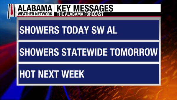
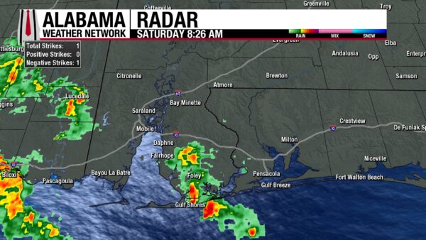
The sun has risen to reveal spots of high clouds over central and south Alabama this morning. Clouds have begun to dissipate toward the north. Temperatures sit in the lower 70s for most of Alabama except for Gadsden, Anniston, Clanton, and Montgomery, which hold onto the upper 60s. It is not as dry a morning as we’ve seen recently with dewpoints in the mid to upper 60s, but it is not too unpleasant. Also, showers have already begun in Baldwin County this morning, and Gulf Shores and Foley wake to a wet morning.
ALABAMA 7 DAY FORECAST
We enter a wetter pattern as a high-pressure system moves east, allowing more moisture to be present over the state. Rain chances are elevated over the next few days across most of the state before we see a low chance of afternoon showers each day later in the week. The state will get quite warm in the coming week as an upper-level ridge will set up to our west and allow highs to rise.
SCATTERED AFTERNOON THUNDERSTORMS THIS WEEKEND
This weekend, the northern half of the state sees a rain chance of 10% on Saturday and 30% on Sunday. Today, the storms will favor the western half of the region, while the eastern half will see little to no rain. Highs will climb to the upper 80s and low 90s today and top out in the low 80s tomorrow.
The southern half of the state sees a 30% chance of storms today and a 40% chance on Sunday.
A more in-depth look shows that the southwest will see the majority of the rain, and it could be quite a rainy day for the region. Showers and thunderstorms will start by 9-10 a.m. and continue throughout the day. Storms will drop quite a bit of rain over the region, especially if they move slowly. Flash flooding is the main concern in the area today, and more information can be found in the Rainfall Outlook section below. The rain will keep the southwest slightly cooler than the rest of the state, as highs will only reach the mid 80s. A similar temperature spread for southwest Alabama is expected tomorrow.
Southeast Alabama, on the other hand, will see only a few isolated showers today. The main story in the region is heat as highs climb to the upper 80s and lower 90s. More widespread showers are expected tomorrow, and highs will hit the upper 80s.
LESS RAIN TO START NEXT WEEK
Rain chances begin to fall on Monday across Alabama, with a 30% chance of showers in the northern half of the state and a 20% chance in the southern half. Again, showers will favor the afternoon time, driven by the heat of the day. Highs on Monday will range from the mid 80s in the north to the lower 90s in the south.
On Tuesday, a 20% chance of showers and thunderstorms spreading across Alabama, and a warming trend begins. Highs will reach the mid to upper 80s in the northern half of the state, while the southern half of the state sits in the lower 90s. Feels-like temperatures will begin to become a concern as moisture in the air makes these highs feel like the mid 90s to around 100 degrees. The 100-degree-feel-like temperatures will be more likely in the southeast.
HOT END TO THE WEEK
The hot temperatures will continue Wednesday through Friday as a high-pressure system lies to our west.
A 20% chance of afternoon showers and thunderstorms is true statewide on Wednesday, and highs will reach the upper 80s and lower 90s statewide. Again, feels-like temperatures will venture into the mid 90s to 100 degrees.
The upper 80s and lower 90s are expected again on Thursday, and the stubborn 20% chance of showers doesn’t budge.
To end the week, we will see mostly widespread lower 90 highs, with a few isolated locations clinging to the upper 80s. Still, a 20% chance of thunderstorms remains.
Any thunderstorms each day will stay sub-severe.
Through next week, please be sure to monitor your friends and loved ones for signs of heat-related illnesses. Signs include but are not limited to fatigue, dizziness, excessive sweating or the inability to sweat, confusion, clammy skin, and nausea or vomiting. Children and the elderly are more susceptible, as well as those who do not have access to shelter from the heat. Additionally, if you must spend multiple hours outdoors, make time for plenty of breaks, find shade, and cool down.
RAINFALL OUTLOOK
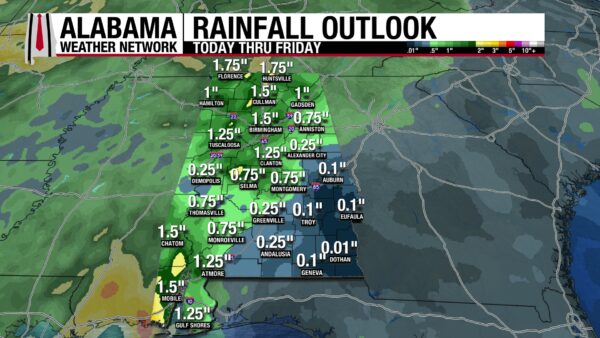
Over the next seven days, much of Alabama will receive 0.25 to 1.75” of rain. The highest concentrations reside in northwest and southwest Alabama. Meanwhile, southeast Alabama could only see less than a tenth of an inch of rain.
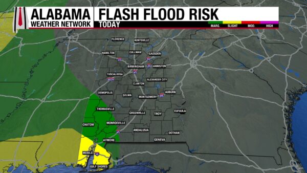
Focusing on the southwest, the region is already quite saturated from last month’s rains. Today, they are expecting to get even more rain, so the Weather Prediction Center has placed the region under a Slight Risk (2/4) near the coast, and Marginal Risk (1/4) more inland for Excessive Rainfall. Both regions have an elevated risk of flash flooding events. Be careful on the roads today, and remember, Turn Around, Don’t Drown.
CONTINUING DROUGHT IMPROVEMENTS
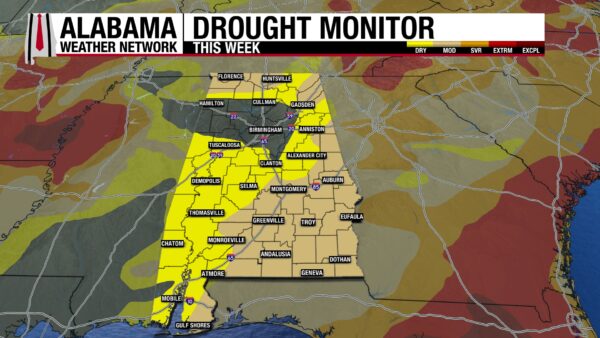
Good news! Alabama is finally coming out of its spring drought. This week’s drought monitor shows there is a Moderate Drought (D1) across the southeast, east, and north portions of Alabama. The rest of the state is not under a drought- parts of west, central, and north Alabama are Abnormally Dry. Eastern north-central Alabama and the Birmingham metro area are drought-free! This is the first week of the year that the drought in Alabama has been less than Severe! After this short dry stretch of weather this week, we’ll fall back into a wet pattern- and hopefully see more improvement this June.
THE PACIFIC IS POPPING
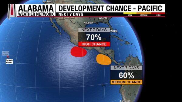
The Pacific is already quite active despite being less than a month into its hurricane season. Tropical Storm Amanda meanders to the southwest, while two areas of interest consider development. The more northern area has a 70% chance of development over the next 7 days, while the southern one has a 60% chance of development.
STORMY SHORES
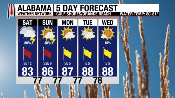
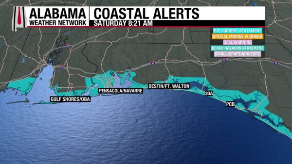
With an 80% chance of thunderstorms, mostly cloudy skies, winds from the southeast up to 15 mph, and a High risk for rip currents, the beach will not be so enjoyable today. Storms have already begun on the coast and will continue on and off throughout the day. The high will be in the lower 80s, but that may be the only redeeming quality today’s forecast has. The surf is rough again today, with a surf height of 3 to 4 feet and Rip Current Statements in effect until tomorrow at 7 a.m. It is strongly advised that beachgoers stay out of the water. Another day of rain and strong rip currents is expected tomorrow.
TODAY IN WEATHER HISTORY
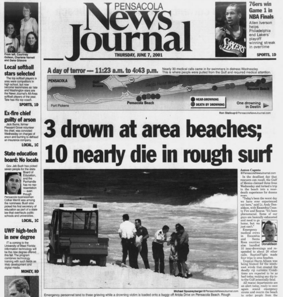
June 6, 2001 – The Deadly Undertow
During early June 2001, Tropical Storm Allison was already becoming one of the most destructive and costly tropical systems in United States history. While the storm’s catastrophic flooding in Texas would eventually dominate national headlines, another deadly danger quietly unfolded hundreds of miles away along the beaches of Northwest Florida.
After moving inland across Texas, the remnants of Allison continued churning moisture and energy across the Gulf of Mexico. At the same time, a strong area of high pressure over the southeastern United States created persistent onshore winds across the northern Gulf Coast. The combination generated powerful long-period swells that rolled steadily toward the beaches from Pensacola eastward through Destin and the Emerald Coast.
What began as rough surf quickly became life-threatening.
Large breakers pounded the shoreline while dangerous rip currents formed along the beaches during the height of the early summer tourist season. Many visitors arriving at the coast saw sunny skies overhead and underestimated the hazards lurking beneath the water’s surface. But beneath the crashing waves, fast-moving channels of water were pulling swimmers rapidly away from shore.
Over two days, the surf turned deadly.
Five people drowned while dozens more required rescue from the violent currents and pounding surf. Rescue crews, lifeguards, law enforcement officers, and even bystanders repeatedly rushed into the dangerous water attempting to save struggling swimmers. According to reporting from the Pensacola News Journal, three people drowned on June 6 alone, while at least ten additional swimmers nearly lost their lives in the rough Gulf conditions.
Among the victims was a 46-year-old Tennessee man who entered the water attempting to rescue his daughters after they became trapped in the rip currents. Another victim, a 48-year-old father, was swimming with his son when the violent surf overwhelmed them. The tragedies unfolded rapidly as swimmers discovered they could not overpower the powerful seaward-moving currents.
Conditions became so dangerous that officials at Pensacola Beach activated storm warning sirens to alert visitors to stay out of the Gulf. The use of the sirens for a surf event was extraordinarily unusual and reflected the severity of the situation unfolding along the beaches. Emergency crews continued responding to calls throughout the day as waves and currents repeatedly swept swimmers into danger.
Meteorologically, the event demonstrated how tropical systems can create deadly coastal hazards far from the center of circulation itself. Allison’s remnants remained well west of Florida, yet the storm’s expansive wind field and generated swells combined with persistent onshore flow to produce highly dangerous surf conditions along the northern Gulf Coast.
Rip currents remain one of the deadliest weather-related hazards along American coastlines because they often appear during otherwise inviting beach conditions. Many victims are tourists unfamiliar with local surf dangers or inexperienced swimmers who panic after being pulled offshore. In many cases, drownings occur not during hurricanes themselves, but during seemingly ordinary beach days influenced by distant tropical systems.
The deadly Northwest Florida surf event of June 2001 became one of the most tragic non-hurricane rip current disasters in modern Panhandle history and reinforced the importance of beach warning systems, surf forecasts, and public awareness along the Gulf Coast.

IMAGE OF THE DAY
Skywatcher Sydney Langley sent in a picture of the beautiful sunset in Arab last night.



