


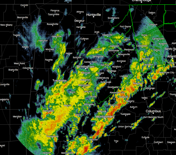
As this title says, flooding has now become the main focus as this severe weather event is starting to wind down for North/Central Alabama. A line of heavy rain and thunderstorms stretches from Roanoke down to the southwest through Alexander City, Eclectic, Montgomery, and Fort Deposit. None of these storms are strong or severe, but there is plenty of rain falling.
Behind that line, a large shield of moderate to heavy rainfall covers the I-20/59 corridor which will continue to add rainfall to the already waterlogged locations in Central Alabama.
A Tornado Watch continues for Barbour, Bullock, Chambers, Elmore, Lee, Lowndes, Macon, Montgomery, Pike, Randolph, Russell, and Tallapoosa counties until 12:00 pm.
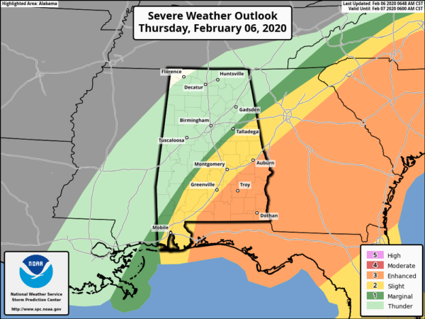
An Enhanced Risk of severe storms continues for much of the southeastern corner of Central Alabama (locations south of I-85). A Slight Risk continues just behind that to a line stretching from Heflin to Clanton to Orrville. A small sliver of the area is in a Marginal Risk just behind the slight and enhanced risk locations. These outlooks will be updated shortly and probably reduced in size and in risk level. Damaging wind gusts up to 60 MPH and a brief tornado will continue to be possible along and ahead of the lead line of storms.
Here is just a sample of flooding reports that we have received so far this morning:
Local Storm Report by NWS BMX: 1 N Gadsden [Etowah Co, AL] emergency mngr reports FLOOD at 03:50 AM CST — many streets reported flooded in gadsden, with water entering homes at 6th st and tuscaloosa ave, and water in homes along gray road.
Local Storm Report by NWS BMX: Altoona [Etowah Co, AL] emergency mngr reports FLOOD at 06 Feb, 01:50 AM CST — flooding reported in altoona, with cars stranded near thomas drive and hwy 132.
Local Storm Report by NWS BMX: Hoover Veterans Park [Shelby Co, AL] emergency mngr reports FLASH FLOOD at 05:00 AM CST — flooding reported along valleydale rd near veterans park, along hwy 119 at broken bow subdivision, and along hwy 31 in pelham.
Local Storm Report by NWS BMX: 5 WSW Newell [Randolph Co, AL] emergency mngr reports FLOOD at 07:13 AM CST — county road 134 in morrison crossroads was washed out. several other roads in the county reported to be flooded.
Local Storm Report by NWS BMX: 1 E Ashville [St. Clair Co, AL] emergency mngr reports FLOOD at 04:30 AM CST — roadway flooding reported across the county, including in the cities of ashville, pell city, margaret, and springville.
Local Storm Report by NWS BMX: Centre [Cherokee Co, AL] emergency mngr reports FLOOD at 04:10 AM CST — water reported over multiple roadways throughout the county, including in centre and cedar bluff.
Marvin Pierce Road close to Beulah Road in Boaz area is impassable due to water over the roadway.
Gene Brown Road in Boaz at Clear Creek and Bulter Mill Road at Bridge over Paint Rock River in Marshall County are impassable due to water.
Road issues in Marshall County are from rising waters. Additional road closures at present are: Horton-Nixon Chapel and Bryant/Mathis Mill (shoulder washout) in Albertville; Mt Vernon Rd, Old Guntersville/Gadsden Rd Boaz; and Red Barn Rd/Old Solitude Rd Guntersville; Bethleham Rd, Jolly Rd, Bearden Rd/Horton, and 205/Turnpike Rd in County.
County Road 112 between AL 75 and Co Rd 112, County Road 386 and Co Rd 173 going to Bucks Pocket state park are all closed with water over the road.
And here is an example of the flooding…
@spann Lakeshore at University Park Pl pic.twitter.com/Wh3xUizdnC
— Amee Goodhew (@agbham) February 6, 2020



