


Daily Weather Briefing
Sunday, January 25, 2026
ALABAMA YESTERDAY
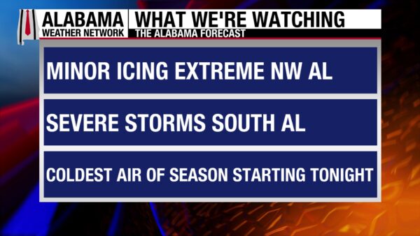
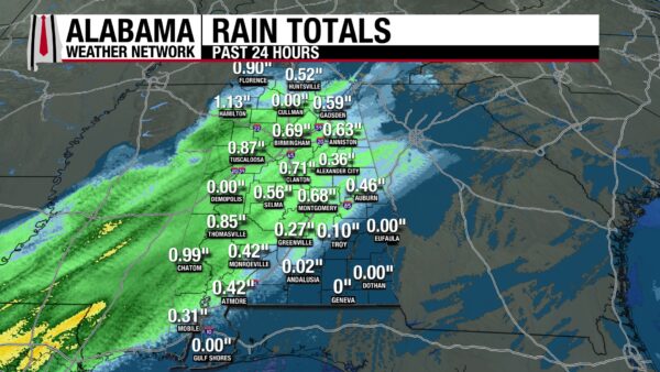
The weather was quite active yesterday, with three different stories across the state. North Alabama received a mix of freezing rain/sleet and rain throughout the day, with many of our Skywatchers giving us real-time, on-the-ground observations. Central Alabama began to see consistent showers in the mid-afternoon hours but was mostly dry beforehand. South Alabama did not see rain until the later afternoon hours, and with showers moving from southwest to northeast, southeast Alabama (south of Montgomery and Phenix City) stayed dry. A Flood Warning was issued for the Tombigbee River and will go into effect on January 28th. Temperatures ranged from the low 30s in the northwest, to the mid 40s further east and south, the 50s from central to south central Alabama, and the mid 60s in the south and on the coast. Rainfall amounts ranged from 0.1” in Troy to 1.13” in Hamilton.
ALABAMA THIS MORNING
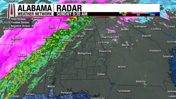
This morning, only rain falls in north and north-central Alabama as temperatures are above freezing. They range from the mid 30s to the low to the upper 50s in this area. The reason for this temperature range is the low-pressure system responsible for this storm is currently located in northwest Alabama. A low-pressure system has warm air in front of it, and cooler air behind it, and the warm air, called the warm sector, is right sitting right in north Alabama. This is why the precipitation is falling as rain and not a wintry mix. Across the rest of the state, dry and cloudy conditions prevail. Temperatures in central Alabama range from the low to mid 40s to the upper 50s because the low-pressure system is more west, so eastern areas do not feel the effects of the warm sector as much. A similar story applies in the south, with southwest Alabama sitting in the mid 60s, and the southeast is in the low to mid 50s.
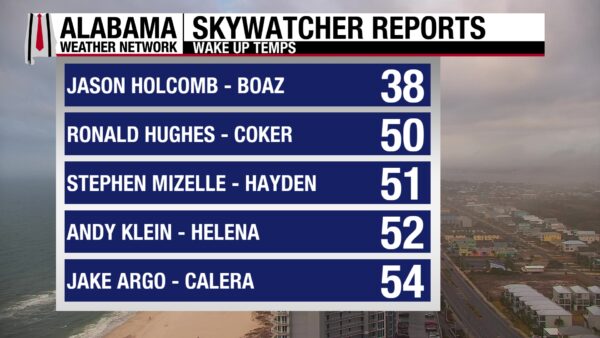
The Skywatchers are reporting temperatures in the upper 30s and low 50s.
ALABAMA 7 DAY FORECAST
Mostly rain and some wintry mix will continue in north Alabama, while thunderstorms and potentially severe storms impact the rest of the state today. Cold temperatures and strong winds ensure a frigid start to the week. A dry cold front will move through Thursday, Friday will be dry and cold, then there is low chance for precipitation again Saturday.
SUNDAY’S SETUP
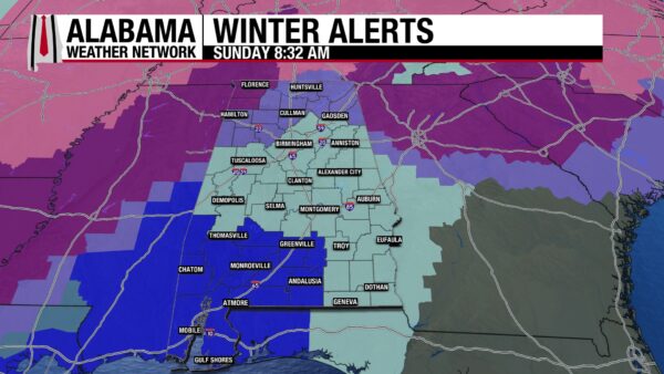
North Alabama: Showers will continue through the morning, with a few pockets still expecting a wintry mix of precipitation. Mostly rain should continue throughout the day, but as the showers move out of the area, another round of wintry precipitation could occur. Highs will be in the low 40s and mid 50s. The Ice Storm Warning in northwest Alabama will expire today at 6 p.m., along with the Winter Weather Advisory for the east. The Weather Prediction Center has the area, except for the northwest, under a Marginal Risk (¼) for Excessive Rainfall so ponding and isolated flash flooding is possible.
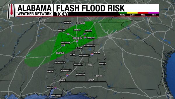
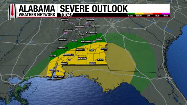
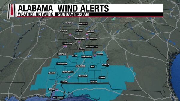
Central and South Alabama: Thunderstorms will begin to move into the area later this morning. The Storm Prediction Center has placed parts of central Alabama under a Marginal Risk (1/5) for Severe Weather and south Alabama under a Slight Risk (2/5). The environment in south-central Alabama will be at first, more favorable to hail formation. Then the environment transitions to be more supportive of damaging winds and isolated tornadoes. These storms will move west to east throughout the day, exiting the state by the afternoon hours. Ensure you are prepared to carry out your safety plan in case of a tornado. A Wind Advisory is in place for south Alabama, where wind gusts stronger than 40 mph are expected. Temperatures will range from the upper 50s to the low 70s. The northern portion of central Alabama is also under a Marginal Risk for Excessive Rainfall today.
VERY COLD TONIGHT!
Behind today’s precipitation, temperatures will plummet across the state as an Arctic airmass rushes in. North Alabama and central Alabama will be under a Cold Weather Advisory from tonight at midnight through tomorrow at 12. Flash freezing and the formation of black ice will make travel dangerous tonight and tomorrow morning. Temperatures will fall into the teens and low twenties, but wind chill will bring feels like temperatures to the single digits and the teens. Southwest Alabama is under an Extreme Cold Warning from midnight to late Monday morning. Temperatures will fall to the low to mid 20s, but wind chill temperatures will be in the 5–15-degree range. A Cold Weather Advisory is in effect for southeast Alabama from tonight through the morning, as temperatures will be in single digits and the teens as well. It will be a very vEry cold night across the state, so ensure you protect yourself, pets, and your property accordingly.
COLD AND DRY THROUGH WEDNESDAY
Monday, temperatures will be in the mid 20s and low 30s north, the mid to upper 30s centrally, and the low to mid 40s in the south. The sun will be out but will offer little warmth to the day. Temperatures will be very cold once again Monday night into Tuesday morning but will warm up a little bit during the day. Highs in the north will be in the upper 30s, central Alabama will be in the low to mid 40s, and the south will be in the upper 40s. Skies will be clear again. Wednesday will have similar conditions.
SLIGHT COOL DOWN FOR END OF WEEK
A dry cold front will move through Thursday, keeping high temperatures in Alabama well below average. Highs Thursday will be in the upper 30s north to upper 40s south. Then Friday will be colder, with the north sitting in the lower 30s and the south in the mid 40s. There is a low chance for precipitation Friday night, so wintry precipitation could fall, but there is still a lot of uncertainty on that front. Saturday will be dry once again, with highs ranging from the lower 30s to the lower 40s from north to south.
RECORDS BROKEN IN LITTLE ROCK
Two records were broken in Little Rock, Arkansas, yesterday. A record low of 9 degrees was recorded, breaking the old record of 10 degrees, set in 2003. 7.8 inches of snow fell at North Little Rock as well. No snow has ever fallen in this area on January 24th before!
WINTER WEATHER CONTINUES
Up to 18 inches of snow will fall in New England through Monday, and half an inch of freezing rain will fall over the Mid-Atlantic and Ohio/Tennessee Valleys. The Lower Mississippi and Tennessee Valley will experience heavy rain today and tomorrow respectively. Then, the Southern Plains to Northeast will experience frigid temperatures through Tuesday. The Great Lakes will receive more lake-effect snow.
SEVERE WEATHER OVER THE GULF COAST
The Central Gulf Coast is under a Slight Risk (2/5) for Severe Weather today. Strong wind gusts, lightning, severe thunderstorms, low chance of hail, and isolated tornadoes are expected today.
NATIONAL HIGH AND LOW
In Ochopee and Sunniland, Florida, the national high of 88 degrees was recorded yesterday. The national low was recorded in Forest Center, Kabetogama, and Brimson, Minnesota, at –43 degrees. We often talk about the difference between the high and the low, but this one takes the cake! This is a temperature range of 131 degrees!
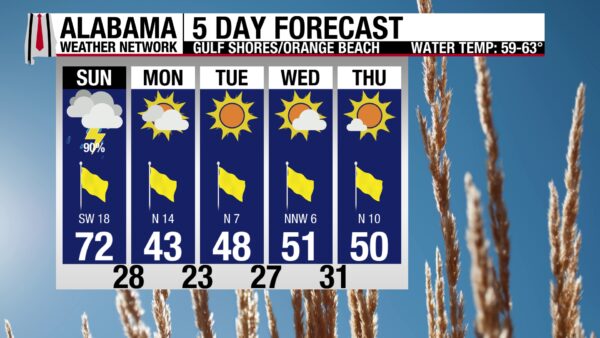
STORMY DAY ON THE BEACH
Today’s rip current risk is high, and life-threatening rip currents are likely. Surf height is around 4 to 6 feet today. There is a 90% chance of showers and thunderstorms and winds will blow around 20 mph. The high temperature will be around 70 degrees. Today might be better spent inside!

20TH YEAR!
Tomorrow’s WeatherBrains episode celebrates the 20th anniversary of the podcast! Join the team as they invite special guests and feature audio from previous episodes.
TODAY IN WEATHER HISTORY
January 24, 1997 – Another Tuscaloosa Tornado
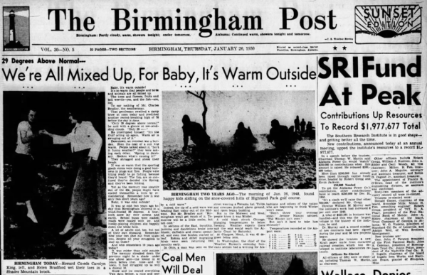
The January Thaw is a climatological phenomenon that occurs in many winters between January 22nd-26th. It is a weather singularity. A singularity is an event that occurs more often than one would expect with chance. The January Thaw is a period of above normal warmth that happens often in the mid-Winter in the Eastern U.S. On January 25, 1950, a strong high-pressure system off the Atlantic Coast caused this phenomenon to be well underway. Strong southerly flow encouraged warm temperatures to flow into the East. Birmingham observed a record high of 78, and Montgomery rose to 80 degrees. Temperatures were 25-30 degrees above average across the east. It was 80 degrees in Meridian, Mississippi, and Shreveport, Louisiana, hit 82 degrees. Other high temperatures on the 25th included 87F in Del Rio, Texas; 83F in Little Rock; 78F in Nashville; 74F in Columbus, Ohio; 78F in Washington, D.C. and 80F in Augusta, Georgia. It was so warm, that cotton was blooming in South Carolina, 5 months before its supposed to! These temperatures were in sharp contrast to the plains and the west, where low temperatures fell to a bitter –34 degrees at Williston, North Dakota, and –32 in Glasglow, Montana.
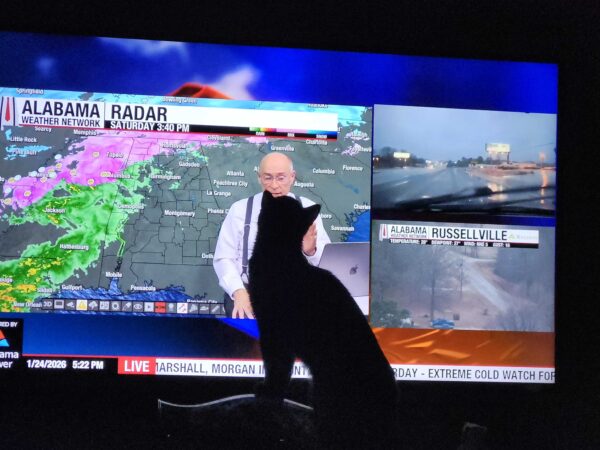
IMAGE OF THE DAY
Soot, Skywatcher Sandra Kirkwood’s cat loves to watch AWN live coverage!



