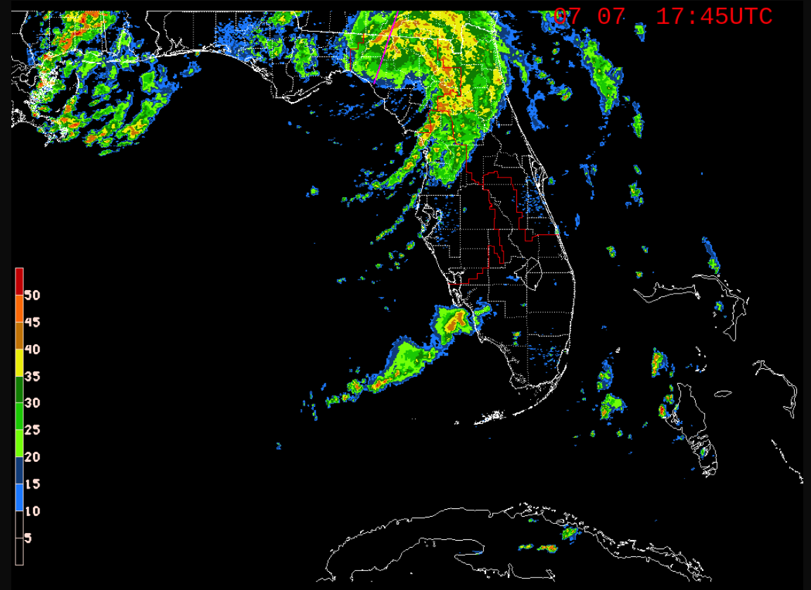
The latest radar image for the state of Florida (Florida State Radar Imagery) shows that much of the activity swirling around the center of Tropical Storm Elsa has moves well inland into northern Florida and into southern Georgia. There is also the following tail on the rear flank of Elsa continuing to bring tropical showers to the far southwestern coast of the Florida Peninsula.
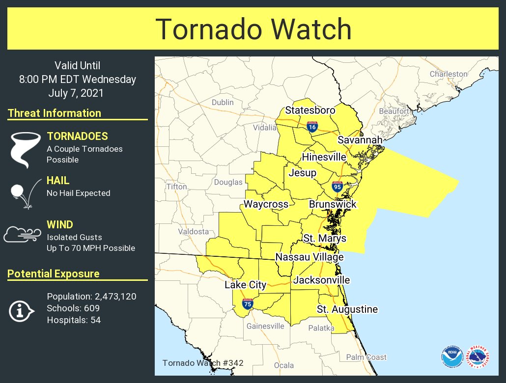
A Tornado Watch has been issued for the extreme northeastern corner of Florida and the southeastern parts of Georgia, including the coastal counties, until 8 pm EDT tonight. Strong low-level winds on the periphery of Elsa along with a warm/moist air mass will continue to allow for the possibility of transient supercells capable of a couple of brief tornadoes.
Here is the 1 pm update from the National Hurricane Center:
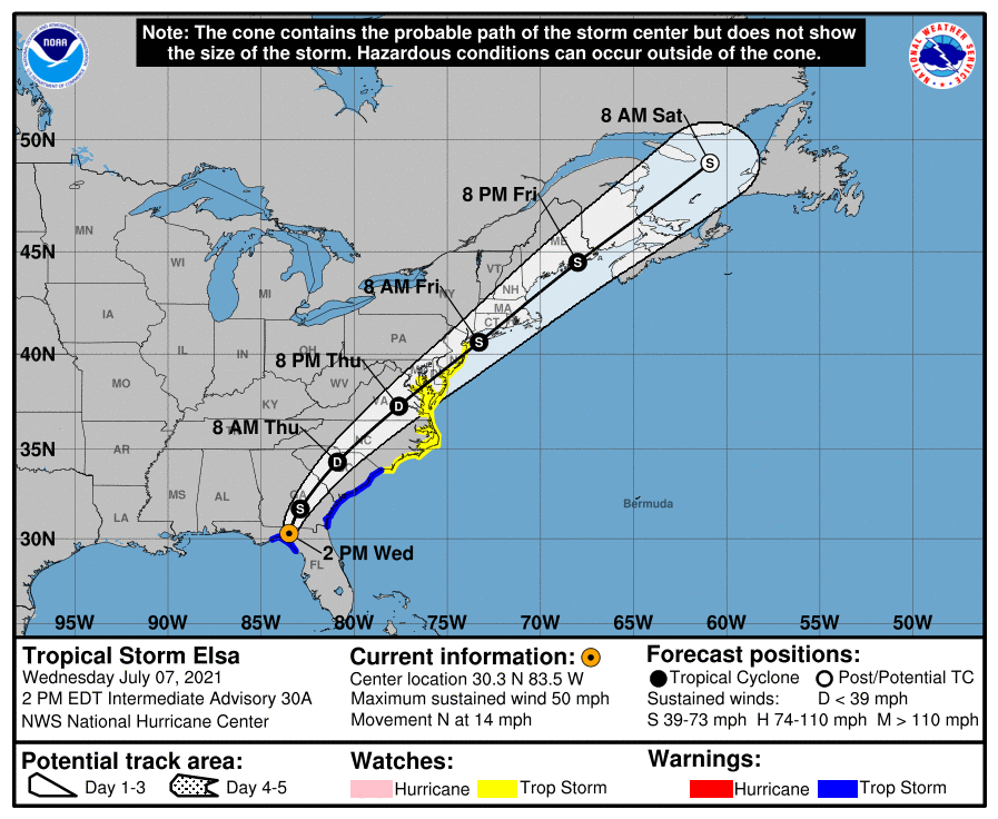
SUMMARY OF 1 PM CDT…1800 UTC…INFORMATION
LOCATION…30.3N 83.5W
ABOUT 105 MI…170 KM W OF JACKSONVILLE FLORIDA
MAXIMUM SUSTAINED WINDS…50 MPH…85 KM/H
PRESENT MOVEMENT…N OR 360 DEGREES AT 14 MPH…22 KM/H
MINIMUM CENTRAL PRESSURE…1002 MB…29.59 INCHES
WATCHES AND WARNINGS
A Storm Surge Warning is in effect for…
* West coast of Florida from the Suwannee River to the Aucilla River
A Tropical Storm Warning is in effect for…
* West coast of Florida from the Suwannee River to the Ochlockonee River
* Mouth of St. Marys River, Georgia to Little River Inlet, South Carolina
A Tropical Storm Watch is in effect for…
* North of Little River Inlet, South Carolina to Sandy Hook, New Jersey
* Pamlico and Albemarle Sounds
* Chesapeake Bay south of North Beach and the tidal Potomac south of Cobb Island
* Delaware Bay south of Slaughter Beach
DISCUSSION AND OUTLOOK
At 200 PM EDT (1800 UTC), the center of Tropical Storm Elsa was located near latitude 30.3 North, longitude 83.5 West. Elsa is moving toward the north near 14 mph (22 km/h). A turn toward the north-northeast is expected this evening, followed by a faster northeastward motion by late Thursday. On the forecast track, Elsa will move over Georgia tonight, over South Carolina early on Thursday, over North Carolina later on Thursday, and move near or over the mid-Atlantic coast on Friday.
Maximum sustained winds have decreased to near 50 mph (85 km/h) with higher gusts. Continued weakening is expected through tomorrow as Elsa moves over land. Tropical-storm-force winds extend outward up to 70 miles (110 km) from the center. The estimated minimum central pressure is 1002 mb (29.59 inches).
HAZARDS AFFECTING LAND
WIND: Tropical storm conditions will continue along the Gulf coast of Florida in the warning area today. Tropical storm conditions are expected in the Tropical Storm Warning area along the Georgia coast by late today or tonight and along the South Carolina coast tonight and early Thursday. Tropical storm conditions are possible in the watch area in the mid-Atlantic and northeastern states by Thursday night and Friday.
STORM SURGE: The combination of a storm surge and the tide will cause normally dry areas near the coast to be flooded by rising waters moving inland from the shoreline. The water could reach the following heights above ground somewhere in the indicated areas if the peak surge occurs at the time of high tide…
* Suwannee River to Aucilla River…2 to 4 ft
* Middle of Longboat Key, FL to Suwannee River including Tampa Bay…1 to 3 ft
* Aucilla River to Ochlockonee River…1 to 3 ft
* Mouth of St. Marys River to South Santee River…1 to 2 ft
Surge-related flooding depends on the relative timing of the surge and the tidal cycle, and can vary greatly over short distances. For information specific to your area, please see products issued by your local National Weather Service forecast office.
RAINFALL: Elsa is expected to produce the following rainfall amounts and impacts the rest of this week:
Across western and northern portions of the Florida Peninsula…3 to 6 inches with localized maximum storm totals up to 9 inches today, which may result in considerable flash and urban flooding, along with minor to isolated moderate river flooding.
Across portions of southeast Georgia and the Lowcountry of South Carolina, 2 to 4 inches with isolated maximum totals up to 6 inches will be possible, which may result in considerable flash and urban flooding.
Across eastern North Carolina into southeastern Virginia…1 to 3 inches with isolated totals up to 5 inches tonight through Thursday night, which could lead to isolated flash and urban flooding.
Across the Northeast and New England, 1 to 3 inches with isolated totals up to 5 inches Thursday into Friday will be possible. This could lead to isolated flash and urban flooding.
TORNADOES: A few tornadoes are possible today and tonight across northern Florida and southeastern Georgia into eastern South Carolina. The tornado threat should shift to the eastern Carolinas and far southeast Virginia on Thursday.
SURF: Swells will continue to affect portions of the west coast of Florida through today. These swells are likely to cause life-threatening surf and rip current conditions. Please consult products from your local weather office for more details.
All images, forecasts, and documents are courtesy of their respective publishers.