


Daily Weather Briefing
Saturday, February 21, 2026
ALABAMA THIS MORNING
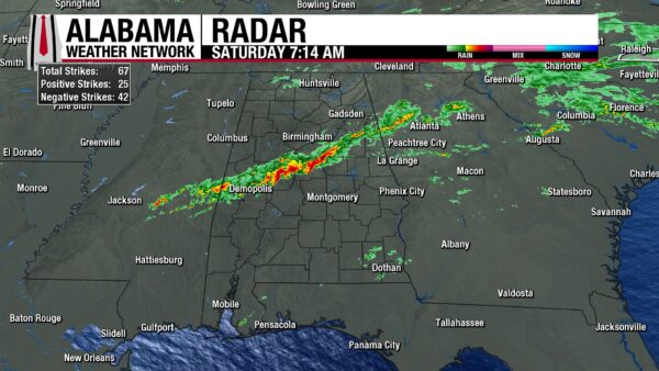
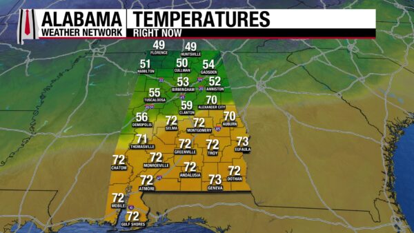
Showers and thunderstorms stretch from Demopolis, through Calera, to Ranburne this morning. Lightning and thunder have been the main impacts of this line of storms so far. Early this morning, a swath of sub-severe thunderstorms impacted north Alabama, but has since moved northeastwards. Over the past 6 hours, trace amounts to 0.64” of rain have been measured through the north half of the state. Although the south is dry right now, clouds and fog envelop the area, indicative of the rain that’s to come. Temperatures sit in the upper 40s and low 50s north, mid to upper 50s in north-central Alabama, and the rest of the state sits in the low 70s. There is a sharp temperature gradient that cuts the state in half through Thomasville to Alexander City where the temperatures jump from 59 to 70. This is where the cold front sits.
ALABAMA 7 DAY FORECAST
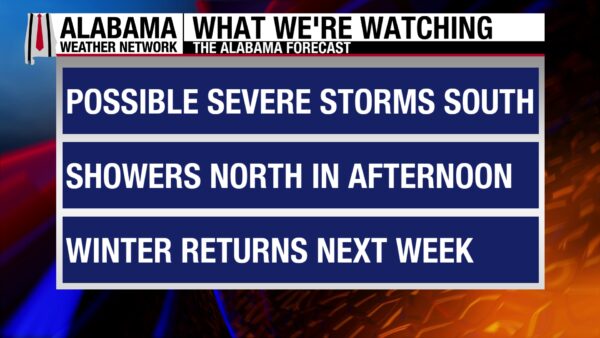
Showers and thunderstorms will continue throughout the day today with south Alabama seeing a low threat for damaging winds, hail, and brief tornadoes. The cold front responsible for today’s weather will exit the state tonight, bringing the return of winter. Sunday through Tuesday will be dry and cold, then a warm-up begins Wednesday. Another cold front will sweep through the state Thursday, with showers and thunderstorms in the forecast. A low chance of showers is expected Friday.
SHOWERS AND THUNDERSTORMS FOR SATURDAY
North and central Alabama will be dry throughout most of the day once these morning storms move out of the area. Then, showers and thunderstorms enter the area from mid to late afternoon. Rain will be light and storms will stay sub-severe. Highs will reach the lower to upper 60s north and the low 70s centrally.
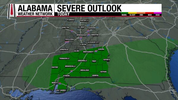
South Alabama will be wetter, with most of its rain still to come. The storms over central Alabama right now will move south-southeast throughout the day. Enough instability and upper-level dynamics are present to support the development of some severe thunderstorms. The Storm Prediction Center has placed the area under a Marginal Risk (1/5) of Severe Thunderstorms. If storms become severe, damaging wind gusts and hail are the most likely threats, but a brief tornado cannot be ruled out. The initial line of thunderstorms will move out by the afternoon, then a second round of showers rolls into the state. In between these two rainmakers, some areas could dry and warm-up, so the better instability and therefore better chance for severe storms is in the afternoon. Highs will reach the mid 70s to low 80s.
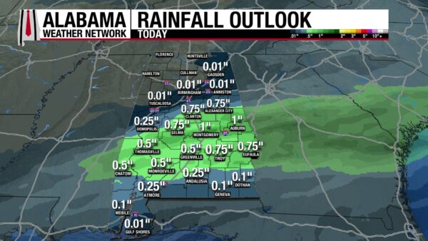
The north will really only receive trace amounts of rain today, but south-central Alabama could see up to one inch. One inch is expected in Auburn, which is great given the worst drought conditions include the city.
CLEARING TONIGHT
Rain and clouds will clear throughout the night as cold air begins to filter into the state. Wind gusts will increase into the morning, gusting from 20mph north to up to 30 mph south. Lows will fall to the chilly low 30s north, mid to upper 30s centrally, low to mid 40s for most of the south, and the upper 40s for southeast Alabama. These temperatures will feel 5-10 degrees colder because of the strong winds.
WINTER RETURNS NEXT WEEK
Sunday begins the three-day stretch of winter temperatures, here to remind us that although spring is around the corner, it’s not here just yet! Highs will only climb to the mid to upper 40s north, low 50s centrally, and upper 50s south. These temperatures will be jarring although not that cold in the grand scheme of cold, because of our unseasonably warm week this past week. Winds will decrease throughout the day but will be strong at times.
Monday will be the coldest of the week, with highs topping out at the upper 30 and low 40s north, mid 40s in the middle part of the state, and upper 40s to low 50s south.
Winter will begin to loosen its grip Tuesday, with highs climbing back into the low 50s north, mid 50s through central/south-central Alabama, and the upper 50s south.
WEDNESDAY WARM UP
Hope for winter-haters and spring-lovers returns Wednesday, as highs jump up into the mid to upper 60s through the northern half of the state, and the low 70s in the southern half.
RAIN CHANCES RETURN THURSDAY AND FRIDAY
A cold front will make for a stormy Thursday, so we will watch the forecast for the development or any hints toward severe weather. Highs will be in the mid to upper 60s from the north to parts of south-central Alabama and in the lower 70s southward.
Friday features much lower rain chances and low temperatures. Highs will sit in the low to mid 50s north, and upper 50s to low 60s elsewhere.

RECORD HIGH LOW TEMP RECORD BROKEN IN ANNISTON
The low temperature in Anniston was 61 degrees yesterday, which breaks the record high low temperature of 60 degrees set in 2018.
CONTINUED WORSENING DROUGHT CONDITIONS
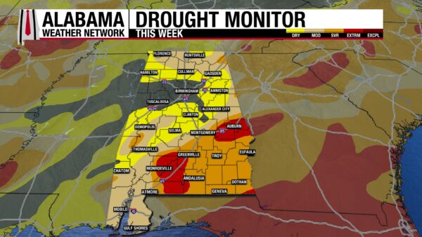
Unfortunately, drought conditions have worsened compared to last week. 13.38% of the state is drought free, which is around a 2% decrease from last week. The Moderate Drought (D1) category has jumped about 4% since last week, with 29.64% of the state experiencing moderate drought conditions. More of the state is experiencing Extreme Drought (D3) conditions as well, with the category jumping from 6.27% last week to 7.68% this week. The rain we will get this today and later this week will only help a little bit in improving these conditions.
BETTER OFF INSIDE
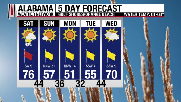
Thunderstorms plague the coast today, with the chance for some to become severe. The high will be in the mid 70s, winds are from the southwest at 10 mph, and the UV Index is moderate, as there will be breaks in the clouds. The stormy weather has riled up the waters, leading to a high risk of life-threatening rip currents and a surf height of 3 to 4 feet. The surf will be dangerous for all swimmers, and extreme caution should be exercised if you get into the water.

TODAY IN WEATHER HISTORY
February 21, 1971 – The Delta Region Tornado Outbreak
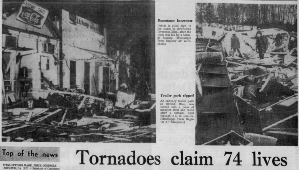
One of the most catastrophic tornado outbreaks in U.S. history struck on Sunday, February 21, 1971, carving a swath of death and destruction across northeastern Louisiana and the Mississippi Delta. The event became known for producing what may be Louisiana’s only F5 tornado and for spawning three massive long-track tornadoes that claimed the majority of the day’s 121 fatalities and over 1,600 injuries.
That morning, a powerful winter storm system was moving across Texas. A surface low near Waco was lifting northeastward, dragging a warm front across northern Louisiana and into Mississippi. South of the boundary, temperatures rose into the upper 70s under sunny skies, with dewpoints in the mid-60s—ideal conditions for explosive thunderstorm development. Aloft, a strong, negatively tilted trough stretched from North Dakota to New Mexico, creating extreme upper-level divergence across the Lower Mississippi Valley.
The first tornado watch of the day—Watch #37—was issued at 9:55 a.m. for northern Mississippi. A second watch was issued at 2:00 p.m. for eastern Louisiana and western Mississippi. By 3:05 p.m., Shreveport radar operators spotted a severe thunderstorm echo over Delhi, Louisiana, 130 miles away. A call to the Louisiana State Police confirmed a tornado near Delhi at 3:12 p.m. Eight minutes later, a tornado warning was issued.
That tornado, later rated F5, touched down just east of Delhi and roared into Mississippi, staying on the ground for 102 miles. It devastated the towns of Delta City and Inverness, where 21 people were killed. In total, the storm killed 46 people—11 in Louisiana and 35 in Mississippi. It remains the only confirmed F5 in Louisiana history.
As that tornado continued its rampage, a second long-track tornado formed near Cary, Mississippi, at 4:10 p.m. It followed a nearly parallel path to the first, staying on the ground for 159 miles. Cary was flattened, and Pugh City was obliterated 46 minutes later, with 22 deaths. In total, this second tornado was responsible for 58 fatalities.
A third major tornado touched down near Bovina, Mississippi, at 5:15 p.m., tracking 69 miles through Yazoo and Holmes Counties. Nine people were killed in Little Yazoo despite the area being under a tornado warning for over an hour. By nightfall, towns like Delta City, Inverness, Cary, Pugh City, and Little Yazoo were either wiped from the map or barely recognizable.
Emergency communication faced serious limitations. Only a handful of TV and radio stations were staffed on Sunday afternoons, and most had no access to the NOAA Weather Wire or radar. Still, tornado warnings were issued with an average lead time of 54 minutes, and all fatalities occurred in counties under a watch. Many residents had heard the warnings and sought shelter—some dove into ditches or lay flat in fields. But the flat, water-table-prone Delta region offered few basements, and the sheer size and violence of the tornadoes overwhelmed even those who took precautions.
Forecasters at the National Weather Service in Jackson and Memphis worked heroically that day, coordinating via NAWAS and relaying reports from the Mississippi Highway Patrol. Meanwhile, the ATS-3 satellite system was installed but not yet operational—it would go live just ten days later.
The outbreak produced 113 known tornadoes, with three of the deadliest tracking a combined 330 miles. Over 611 homes were destroyed. In just a few terrifying hours, the Delta had been laid bare. The scale of the outbreak and its human toll placed February 21, 1971, among the deadliest days in American severe weather history.
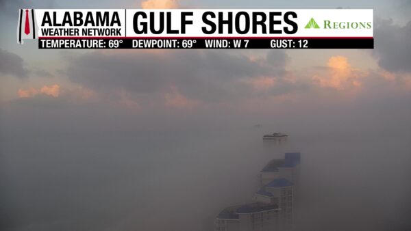
IMAGE OF THE DAY
Today’s Image of the Day comes from out Gulf Shores Regions Skycam of a beautifully foggy sunrise on the coast.



